
 Menu
MenuSearch the Gazetteer
Are the results not as expected? Modify your search term or change the scope to refine your search.
Results for a place that exactly matches ...
Worcestershire
Worcestershire, England
 Worcestershire is an inland county in the English Midlands. The centre of the county comprises the fertile lowland plain drained by the Rivers Severn and Avon and their tributaries, the Rivers Stour and Teme. The cathedral city of Worcester stands on the Severn and is dominated by a grand cathedral. In the south-east of the county the pleasant Vale of Evesham provides excellent soil for orchards and market gardening. Evesham itself was founded around an early 8th-century abbey. In the south-west are the pretty Malvern Hills. Great Malvern is a lovely spa town. The far south-east of Worcestershire lies in the Cotswolds, Broadway being known as the "Jewel of the Cotswolds". In contrast, the north-east of the county is urban in character, including the Black Country town of Oldbury, many of Birmingham's outer southern suburbs and the towns of Halesowen, Stourbridge, Bromsgrove and Redditch. Even in this corner of the county there remain havens of peace in the Clent Hills and the Lickey Hills. A huge area in the north-west of the county, much of it part of the Teme valley, in unspoilt countryside without even small towns.
Place Type: Historic County
Lat, Long: 52.200893,-2.313989
Grid Reference: SO786558
Country: England
GBPNID: 305841
Entry Type: Main listing (P)
URL: https://gazetteer.org.uk/place/Worcestershire,_305841
 Explore Worcestershire on Wikishire
The central part of Worcestershire is dominated by the River Severn which flows north to south across the entire county. The Severn enters Worcestershire from Shropshire near the small town of Bewdley, which lies along the river's west bank. Bewdley is the headquarters of the Severn Valley Railway. To the east of Bewdley is Kidderminster, famed for its carpet production;
The Severn flows south to Stourport-on-Severn, a town built around its canals and basins. The surrounding area has several large manor and country houses. Hartlebury Castle is a 13th-century fortified manor house. Astley Hall is a three-storey country house which was the home of Prime Minister Stanley Baldwin from 1902 to his death there in 1947. Areley Hall is a 16th-century country house. Harvington Hall is a moated mediæval and Elizabethan manor house.

Harvington Hall
The Severn flows south to the fine city of Worcester, in the centre of the shire. Worcester is dominated by Worcester Cathedral, around which it retains many charming streets. 'The Greyfriars' (NT) in Friar Street is the finest half-timbered building in the city. Nearby Droitwich Spa is a town which stands on top of large deposits of salt. In the Victorian period the town attracted many visitors to bathe in the briny waters. Hanbury Hall (NT), to the east of Droitwich, was built by the wealthy chancery lawyer Thomas Vernon in the early 18th century.

Worcester Cathedral Choir
From Worcester, the Severn meanders south to the small town of Upton-upon-Severn. The town has a distinctive tower and copper-clad cupola known locally as the Pepperpot and the only surviving remnant of a former church. The 16th-century Neo-Palladian Croome Court (NT) is near the town. From Upton, the Severn continues southward into Gloucestershire.

Pershore Abbey
In the south-east of the county is the pleasant Vale of Evesham, an area comprising the flood plain of the River Avon. The Vale is famed for its fruit production. The market town of Pershore stands on the Avon, 10 miles south-west of Worcester. The town is best known for Pershore Abbey, Pershore College, and the plums and pears grown locally. Evesham itself was founded around an early 8th-century abbey, which was once one of the largest in Europe. Only Abbot Lichfield's Bell Tower remains. Evesham is on a horse-shoe shaped peninsula almost completely surrounded by water in a loop of the River Avon and prone to flooding. To the north-east is the 14th-century Middle Littleton Tithe Barn (NT).
The far south-east of Worcestershire lies in the Cotswolds. The village of Broadway is often referred to as the "Jewel of the Cotswolds". Bredon Hill is a Cotswold hill that stands slightly isolated south-west of Evesham. At the summit of the hill, there are the remains of earthworks from an Iron Age hill fort known as Kemerton Camp. There are also Roman earthworks and a number of ancient standing stones on the hill.

Broadway
In the south-west, forming the boundary with Herefordshire, are the pretty Malvern Hills, a sheer, sharp north-south edge marking the end of the gentle hills in Worcestershire before the rigours of the Herefordshire peaks. Great Malvern standing in their shade is a lovely spa town that grew around the pure waters issuing from the hills. Great Malvern Priory was a Benedictine monastery (c. 1075 – 1540) and is now an Anglican parish church. Birtsmorton Court is a fortified mediæval moated manor house near Great Malvern.

Great Malvern Priory
The north-east of Worcestershire is a complete contrast to the rural heart, covered over with a conurbation spreading out across the county borders. This and the neighbouring part of Staffordshire were coal country, known as the Black Country from the coal beneath and the smoke above, the latter now thankfully cleared. Much of the Black Country is in Worcestershire, including including the former industrial towns of Cradley, Oldbury and Warley. Dudley, the unofficial capital of the Black Country, lies in an enclave of Worcestershire, though locally within Staffordshire.

Bromford Junction and Spon Lane bottom lock, Oldbury
Outside the Black Country itself but still more or less absorbed within the same unbroken townscape are quieter towns. Halesowen is predominantly urban in character, but borders on green belt land with excellent access to the countryside, for example the popular Clent Hills. Stourbridge was the centre of British glass making during the Industrial Revolution. Stourbridge glass is recognised as amongst the finest in the world, although in recent years the industry has sharply declined. Northfield is a small town on the southern outskirts of metropolitan Birmingham. A centre of nail making in the 19th century, today Northfield is predominantly a residential and dormitory suburb. The Bournville model village lies in its northern reaches.
To the south of the conurbation lies Bromsgrove, once a centre for woollen cloth and for nail-making, today mainly a commuter town. The Forge Mill Needle Museum at Redditch tells the story of how the town became the world centre for needle manufacture. In the 1960s Redditch was designated a "new town" and has seen massive expansion, much of it over the border into Warwickshire.
.jpg)
Forge Mill Needle Museum, Redditch
A huge area in the west and the north-west of Worcestershire, much of it part of the Teme valley, in unspoilt countryside without even small towns. The Firs (NT) in the village of Lower Broadheath is the birthplace of Edward Elgar. Witley Court (EH) was once one of the great houses of the Midlands, but is now a spectacular ruin following a fire in 1937. The two immense fountains survived and the larger, the Perseus and Andromeda Fountain, has been restored to working order by English Heritage. Nearby Abberley Hall is an Italianate house which dates from 1846–49.

Perseus and Andromeda Fountain, Whitley Court
In the far north-west the county lunges westward between Herefordshire and Shropshire. The small market town of Tenbury Wells, known for its "Chinese-gothic" Pump Room buildings, sits on the border, in a landscape as far removed from the county's north-east as it could possibly be.

Pump Rooms, Tenbury Wells
Worcestershire has Iron Age hill forts in the Malvern Hills and on Bredon Hill. Worcester contains small traces of the Roman occupation. The Hwicce tribe were the first Anglo-Saxon settlers, creating a Hwiccean kingdom by 679 with a separate diocese with its seat at Worcester. The region later became part of the kingdom of Mercia, though was temporarily conquered by the Danes in the 9th century. The shire itself is believed to originate from the period after the Anglo-Saxons had recovered Mercia from the Danes. The church was enormously influential in Worcestershire during the Middle Ages, with 13 monastic foundations existing in the county between the 8th and 13th centuries. It was the monks of Evesham and Pershore abbeys who began the cultivation of the flowers, fruits, and vegetables in the Vale of Evesham. At Domesday (1086), the church owned more than half of the land in Worcestershire. Consequently, Worcestershire is studded with old churches, abbeys, and priories. The county also has many fine half-timbered country houses dating from the 15th and 16th centuries.
Two decisive battles in English history were fought in Worcestershire. At Evesham in 1265 Simon de Montfort was slain by the forces of Edward (later Edward I). At Worcester in 1651 a Parliamentary army led by Oliver Cromwell resoundingly defeated the Scottish forces of Charles II and thus brought to an end the English Civil Wars. The south of the county thrived on on the production of wool and woollen cloth from the late Middle ages. Coal and iron were mined in the north of the county from as early as the 13th century. The Industrial Revolution saw the north-east of the county become part of the heavily industrialised Black Country, famed for its coal mining and metal production. Elsewhere, Worcester was a centre for the manufacture of gloves; Kidderminster became a centre for carpet manufacture, and Redditch specialised in the manufacture of needles, springs and hooks.
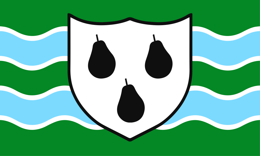
The Worcestershire flag features three of the county's famed pears on a shield charged against a wavy green and blue background. The latter colours symbolise the verdant flood plain of the River Severn. The dark green hue is that worn by the county's cricket team.