
 Menu
MenuSearch the Gazetteer
Are the results not as expected? Modify your search term or change the scope to refine your search.
Results for a place that exactly matches ...
Stirlingshire
Stirlingshire, Scotland
Stirlingshire is a county which stands across the gateway to the Highlands. The county spreads across the narrow band from the head of the Firth of Forth in the east, across the low hills of the Campsie Fells in the county's centre, out to Loch Lomond in the west. The River Forth forms the northern border with Perthshire, from the Firth until it turns north into Perthshire near Gartmore. Loch Lomond forms the western border with Dunbartonshire.
Place Type: Historic County
Lat, Long: 56.046944,-4.100464
Grid Reference: NS692857
Country: Scotland
GBPNID: 305810
Entry Type: Main listing (P)
URL: https://gazetteer.org.uk/place/Stirlingshire,_305810
 Explore Stirlingshire on Wikishire
In the north-west of the county is a spur of the Grampian Mountains, the spur culminates in the Arrochar Alps, and their summit, Ben Lomond (3,196 feet), the county top.

Ben Lomond from the Campsie Fells
The centre of Stirlingshire is occupied by a group of more modest hills known as the Lennox Hills, consisting of the Campsie Fells, the Kilsyth Hills, the Fintry Hills and the Gargunnock Hills. Culcreuch Castle, a rectangular tower house first built in 1296, lies near the village of Fintry.
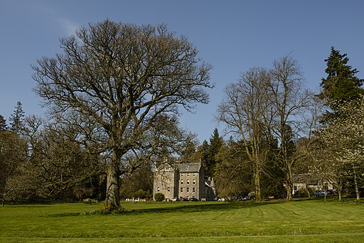
Culcreuch Castle
Lennoxtown, at the foot of the Campie Fells, was once a busy industrial town, beginning with calico mills and expanding to other products. Since the mills stopped turning however it has been forced to seek a new role. Kilsyth occupies a narrow strip of land between the Kilsyth Hills and the River Kelvin, the border with the eastern part of Dunbartonshire.
The county town, Stirling, stands on a precipitous hill above the River Forth, crowned with an eleventh-century castle. Stirling was Scotland's capital or co-capital for centuries. Its importance though is also in its position; in the Middle Ages Stirling Bridge was portrayed as the only link joining the Lowlands to the Highlands. The castle was the scene of fearsome clashes in the wars which racked the British Isles in the Middle Ages. Stirling is a somewhat more peaceful city these days, but it is still the major conduit for road and rail from the Lowlands to the Highlands.
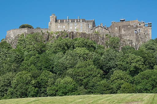
Stirling Castle
Bridge of Allan lies north of Stirling, and north of the River Forth, named for its bridge over the river on which it lies. Immediately south of Stirling is Bannockburn, site of the Battle of Bannockburn 1314. It is named after the Bannock Burn, which flows through the village before entering the River Forth.
To the south-west of Stirling are the former industrial towns of Bonnybridge and Denny. To the south-east of Bonnybridge is a well preserved section of the Antonine Wall, and the remnants of Rough Castle Fort, the most complete surviving Roman fort of the wall.
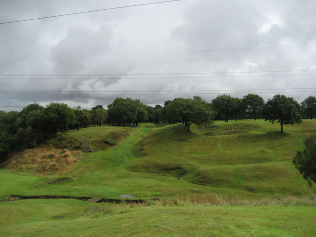
Antonine Wall (ditch) and Rough Castle Fort (ridges and mounds) near Bonnybridge
The south-east of the county is more heavily populated. The towns of Falkirk, Denny, Larbert and Stenhousemuir were formerly a centre of heavy industry but their economies are now based increasingly on retail and tourism. The Antonine Wall passes through Falkirk and remnants of it can be seen at Callendar Park. The Falkirk Wheel, the only rotary canal connector in the world, has connected the Forth and Clyde Canal to the Union Canal since 2002. The oil refinery at Grangemouth (opened in 1924) provides employment throughout the region.

The Falkirk Wheel
Milngavie, in the south-west of the county, is a commuter town for Glasgow. A granite obelisk in the town centre marks the official starting point of the West Highland Way footpath which runs northwards for 95 miles to Fort William.
The Antonine Wall, constructed by the Romans in AD 142, connects the Rivers Forth and Clyde and passes through south-eastern Stirlingshire. After the withdrawal of the Romans, the native Picts slowly retreated before the advance of the Anglo-Saxons and Scots. Stirling received a royal charter from David I (c. 1130) and became a trading centre. King David I held court at Stirling often, a precedent followed by his successors so that it became for some time an effective capital of the kingdom. The earliest written reference to Stirlingshire appears in a charter of 1150 under the name 'Striuelinschire'. Stirlingshire played a conspicuous part in the struggle for Scottish independence as the site of several of the exploits of Sir William Wallace and Robert the Bruce. The three great battles for independence, Stirling Bridge (1297), Falkirk (1298), and Bannockburn (1314), were all fought in Stirlingshire. James III was stabbed to death in Milton following the Battle of Sauchieburn (1488). The Covenanters met with defeat at Kilsyth in 1645. The victory of Prince Charles Edward, the Young Pretender, at Falkirk in 1746 was the last significant battle in Stirlingshire.
The industrial development of the south-east of the county in the 18th and 19th centuries was driven by its coalfield and the completion of the Forth and Clyde Canal in 1790. Mining and iron and steel production declined dramatically in the 20th century. This has been tempered by the development of the petrochemical industry at Grangemouth, and by the development of light manufacturing and service activities in many of the county’s towns.

The Forth and Clyde Canal at Grangemouth
Place Type: Historic County
Lat, Long: 56.046944,-4.100464
Grid Reference: NS692857
Country: Scotland
GBPNID: 305810
Entry Type: Main listing (P)
URL: https://gazetteer.org.uk/place/Stirlingshire,_305810
Explore Stirlingshire on WikishireIn the north-west of the county is a spur of the Grampian Mountains, the spur culminates in the Arrochar Alps, and their summit, Ben Lomond (3,196 feet), the county top.
.jpg)
Ben Lomond from the Campsie Fells
The centre of Stirlingshire is occupied by a group of more modest hills known as the Lennox Hills, consisting of the Campsie Fells, the Kilsyth Hills, the Fintry Hills and the Gargunnock Hills. Culcreuch Castle, a rectangular tower house first built in 1296, lies near the village of Fintry.
.jpg)
Culcreuch Castle
Lennoxtown, at the foot of the Campie Fells, was once a busy industrial town, beginning with calico mills and expanding to other products. Since the mills stopped turning however it has been forced to seek a new role. Kilsyth occupies a narrow strip of land between the Kilsyth Hills and the River Kelvin, the border with the eastern part of Dunbartonshire.
The county town, Stirling, stands on a precipitous hill above the River Forth, crowned with an eleventh-century castle. Stirling was Scotland's capital or co-capital for centuries. Its importance though is also in its position; in the Middle Ages Stirling Bridge was portrayed as the only link joining the Lowlands to the Highlands. The castle was the scene of fearsome clashes in the wars which racked the British Isles in the Middle Ages. Stirling is a somewhat more peaceful city these days, but it is still the major conduit for road and rail from the Lowlands to the Highlands.

Stirling Castle
Bridge of Allan lies north of Stirling, and north of the River Forth, named for its bridge over the river on which it lies. Immediately south of Stirling is Bannockburn, site of the Battle of Bannockburn 1314. It is named after the Bannock Burn, which flows through the village before entering the River Forth.
To the south-west of Stirling are the former industrial towns of Bonnybridge and Denny. To the south-east of Bonnybridge is a well preserved section of the Antonine Wall, and the remnants of Rough Castle Fort, the most complete surviving Roman fort of the wall.

Antonine Wall (ditch) and Rough Castle Fort (ridges and mounds) near Bonnybridge
The south-east of the county is more heavily populated. The towns of Falkirk, Denny, Larbert and Stenhousemuir were formerly a centre of heavy industry but their economies are now based increasingly on retail and tourism. The Antonine Wall passes through Falkirk and remnants of it can be seen at Callendar Park. The Falkirk Wheel, the only rotary canal connector in the world, has connected the Forth and Clyde Canal to the Union Canal since 2002. The oil refinery at Grangemouth (opened in 1924) provides employment throughout the region.

The Falkirk Wheel
Milngavie, in the south-west of the county, is a commuter town for Glasgow. A granite obelisk in the town centre marks the official starting point of the West Highland Way footpath which runs northwards for 95 miles to Fort William.
The Antonine Wall, constructed by the Romans in AD 142, connects the Rivers Forth and Clyde and passes through south-eastern Stirlingshire. After the withdrawal of the Romans, the native Picts slowly retreated before the advance of the Anglo-Saxons and Scots. Stirling received a royal charter from David I (c. 1130) and became a trading centre. King David I held court at Stirling often, a precedent followed by his successors so that it became for some time an effective capital of the kingdom. The earliest written reference to Stirlingshire appears in a charter of 1150 under the name 'Striuelinschire'. Stirlingshire played a conspicuous part in the struggle for Scottish independence as the site of several of the exploits of Sir William Wallace and Robert the Bruce. The three great battles for independence, Stirling Bridge (1297), Falkirk (1298), and Bannockburn (1314), were all fought in Stirlingshire. James III was stabbed to death in Milton following the Battle of Sauchieburn (1488). The Covenanters met with defeat at Kilsyth in 1645. The victory of Prince Charles Edward, the Young Pretender, at Falkirk in 1746 was the last significant battle in Stirlingshire.
The industrial development of the south-east of the county in the 18th and 19th centuries was driven by its coalfield and the completion of the Forth and Clyde Canal in 1790. Mining and iron and steel production declined dramatically in the 20th century. This has been tempered by the development of the petrochemical industry at Grangemouth, and by the development of light manufacturing and service activities in many of the county’s towns.

The Forth and Clyde Canal at Grangemouth