
 Menu
MenuSearch the Gazetteer
Are the results not as expected? Modify your search term or change the scope to refine your search.
Results for a place that exactly matches ...
Shropshire
Shropshire, England
 Shropshire is an inland county in the west of the Midlands. The county has been described as possessing every variety of natural charm: the bold and lofty mountain, the wooded and secluded valley, the fertile and widely-cultured plain, the majestic river, and the sequestered lake. The River Severn forms a broad, rich valley and floodplain through the middle of the county, curling around Shrewsbury like a moat. Downstream the Severn Gorge is bridged by the famous Iron Bridge, a symbol of the Industrial Revolution which took root here. To its north lies the New Town of Telford. A mile to its west is witness to earlier ages; the Wrekin, a lone, massive hill dominating the landscape and imagination. Further downstream is Bridgnorth, a town full of history on a precipitous hill above the Severn. North of the Severn lies the gentler landscape of the North Shropshire Plain. Around Ellesmere is a group of small lakes, the “meres”. Westward, where the hills begin to rise, lies the historic town of Oswestry. South of the Severn, stretching down to Ludlow, the Shropshire Hills provide the scenic glories of high, rounded hills, deep-set valleys, and woods full of charm.
Type: Historic County
Lat, Long: 52.706437,-2.68514
Grid Reference: SJ538123
Country: England
 Explore Shropshire on Wikishire
The North Shropshire Plain is an extension of the flat and fertile Cheshire Plain. In the north-west of the county, around Ellesmere is a group of small lakes, the "meres", including Ellesmere itself. However westward the hills begin to rise. At the edge of this area is the historic border town of Oswestry. In 641 King Oswald of the Northumbrians was slain in battle by Penda of Mercia and his body dismembered. Here then was founded the abbey of Oswaldes treow; Oswestry, which grew from pilgrimage and those seeking the healing qualities attributed to the well here. The battle may have been fought at Old Oswestry, an Iron Age hill fort north of the town. The 13th-century Whittington Castle stands nearby.

Old Oswestry
In the north-east of the county lies the Roman town of Whitchurch, which claims to be the oldest continuously inhabited town in Shropshire. The small town of Wem, to the south of Whitchurch, is famous for its brewing heritage. On the Staffordshire border is the small market town of Market Drayton, a notable centre of food production. The Shropshire Union Canal is navigable through the town.
The River Severn shapes much of Shropshire. It passes through the middle of the county forming a broad, rich valley and floodplain. The Severn curls around Shrewsbury, the county town, like a moat. Shrewsbury is a town built on a hill above the Severn with the mediæval Shrewsbury Castle, a largely unspoilt mediæval street plan and hundreds of historic buildlings. It was King Charles I's capital for a while too. Shrewsbury Abbey was, until the reformation, the church belonging to the town's great abbey, founded in 1083. The area around the town is rich in historic buildings. To the south-east is Attingham Park (NT), an 18th century country house and estate. To the north-east is Haughmond Abbey, a ruined, mediæval, Augustinian monastery. Further to the north-east is Moreton Corbet Castle (EH), the ruins of a mediæval stronghold and an Elizabethan-era manor house.

The River Severn at Shrewsbury
Further downstream the Seven enters the Severn Gorge where it is bridged by the famous Iron Bridge, a symbol of the Industrial Revolution which took root here. The town of Ironbridge which grew up from the works around the bridge is no longer at the cutting edge of industrial advances. It is a UNESCO World Heritage site. A few miles from the gorge is Benthall Hall (NT), a 16th-century country house with a fine oak interior and an elaborate 17th-century staircase.

The Iron Bridge
Immediately north of Ironbridge is Telford, Shropshire's largest town. Telford was built in the 1960s and 1970s as a new town on previously industrial and agricultural land. Telford was created from the merging of other, smaller towns and villages, most notably the towns of Wellington, Oakengates, Madeley and Dawley. The town takes its name from the famous engineer Thomas Telford who served as Surveyor of Public Works for Shropshire from 1787 and built 40 bridges in the county. A mile or so west of Telford is witness to earlier ages; the Wrekin, a lone, massive hill dominating the landscape and imagination and which has given a name since immemorial time to the area; Roman Viroconium, Saxon Wrocensæt, Wroxeter and Wrockwardine, and a contemporary administrative district.

The Wrekin
To the east of Telford, on the Staffordshire border, is Boscobel House (EH), famous for its role in the escape of Charles II after the Battle of Worcester. The house was built on land belonging to White Ladies Priory (EH) prior to its dissolution. The ruins of the priory can still be seen.
Downstream of Ironbridge is Bridgnorth, a town full of history on a precipitous hill above the Seven. The ruins of its castle stare down over the Severn Valley it once commanded. The High Town and Low Town are linked by the Cliff Railway, England’s oldest and steepest inland electric funicular railway. Near the town are two notable historic properties. Dudmaston Hall (NT) is a 17th-century country house with landscaped gardens and parkland. Morville Hall (NT) is a large 16th-century grey stone mansion on the site of the abandoned Morville Priory.

The Cliff Railway, Bridgnorth
South of the Severn, Shropshire has new scenic glories of wilder hills, especially westward towards Radnorshire. In this part of the shire are high, rounded hills, deep-set valleys, and woods full of charm. Much of this area forms the Shropshire Hills Area of Outstanding Natural Beauty.
The Wenlock Edge is a limestone escarpment running for 20 miles from the small market town of Much Wenlock, south-east of Shrewsbury, down to Craven Arms near the Herefordshire border. Near it's northern end are the ruins of Wenlock Priory. The visible ruins are those built by the Normans after an earlier abbey was destroyed by the Danes. St Milburga (d. 23rd February 727) was the Benedictine abbess of Wenlock Priory. She is said to have had a mysterious power over birds and was associated with miracles, such as the creation of a spring and the miraculous growth of barley. Further south-west along the edge is Wilderhope Manor (NT), an Elizabethan-period manor house, built of local limestone and dating from 1585.

The Long Mynd
The small town of Church Stretton lies among the Shropshire Hills. The town was nicknamed Little Switzerland in the late Victorian and Edwardian period for its landscape, and became a health resort. Overlooking the town is Caer Caradoc, crowned with a hill fort from which are panoramic views: to the north towards The Wrekin; west over the nearby Long Mynd; and east to Wenlock Edge (an inspiration for Housman's A Shropshire Lad). Brown Clee Hill (1,772 feet), the county top, lies among the Clee Hills further to the south-west. There is a 'discovery centre' for the Shropshire Hills in the small town of Craven Arms. Close to the town is the 13th-century Stokesay Castle (EH).

Stokesay Castle
The chief town of the south of the county is Ludlow. Set on a hill, it retains its age-worn charm and is full of fine timbered houses. Ludlow Castle stands high on its hill above the River Teme, one of the finest castles in the land. In the south-east of the county is the small market town of Cleobury Mortimer, birthplace of William Langland, author of The Dream of Piers Plowman, one of the greatest of works of English literature in the Middle Ages.
Bishop's Castle, in the south-west close to the border, has become known for its alternative community of artists, musicians, writers and craftspeople. To its south is the tiny, tranquil town of Clun. Clun Castle (EH) was an important Marcher lord castle in the 12th century.
Shropshire has many Bronze Age remains, including round barrows near Ludlow. Mitchell's Fold is a Bronze Age stone circle on Stapeley Hill, close to the Montgomeryshire border. There are many Iron Age hill forts including those at Bury Ditches, Hopesay Burrow Camp, Caer Caradoc, the Wrekin, and Old Oswestry.

Mitchell's Fold
The 1st-century Roman legionary fortress at Wroxeter (Viroconium), south-east of Shrewbury, was one of the largest towns in Roman Britain. There are substantial visible remains of the city, dwarfing the village of today. After the Roman withdrawal, the Shropshire area was in the eastern part of the Welsh Kingdom of Powys. Lowland Powys was annexed to the Kingdom of the Mercians by King Wulfhere.

Wroxeter
Subsequently, the county’s position on the boundary between England and Wales has shaped its history. King Offa constructed Offa's Dyke in the 8th-century, a boundary between Mercia and the principalities of Wales. The earliest recording of the county name, as "Scrobbesbyrigscir", is from 1006. The alternative name, Salop, from the Latinised "Salopesberia", is rarely used nowadays, though Shropshire residents are still referred to as "Salopians".
After the Norman Conquest, large areas of Shropshire were set aside as forests and hunting grounds, and numerous defensive castles built. Mediæval Shropshire witnessed many Welsh incursions and baronial rebellions. Shropshire acquired the borders we know today following the abolition of the Welsh Marcher lordships by the Laws in Wales Act 1535. The lordships of Oswestry, Whittington, Maesbrooke and Knockin were formed into the hundred of Oswestry which was attached to Shropshire. The lordship of Ellesmere was joined to the Shropshire hundred of Pimhill. The lordship of Down was joined to the Shropshire hundred of Chirbury. Many in these areas retain a sense of Welsh identity. Welsh place names are common. Many Welsh speakers live in these areas, especially in Oswestry.

Offa's Dyke by Llanfair Hill, west of Clun
Shropshire wool brought prosperity to Ludlow, Shrewsbury, and Bridgnorth from the 13th-century. Shrewsbury became the market for a huge area, including much of north Wales. Abraham Darby came to Coalbrookdale in the early 18th-century and developed his method of smelting ironstone with coke. Shropshire became the greatest iron-producing area in England. The world’s first cast-iron bridge was erected at Ironbridge in 1779. A network of canals linked the Severn with the Rivers Dee, Mersey, and Stour. Despite its industrial heritage, Shropshire is still principally an agricultural county. There are many cattle markets at Shrewsbury, Ludlow, and Oswestry. Craven Arms has some of the largest sheep sales in the country.
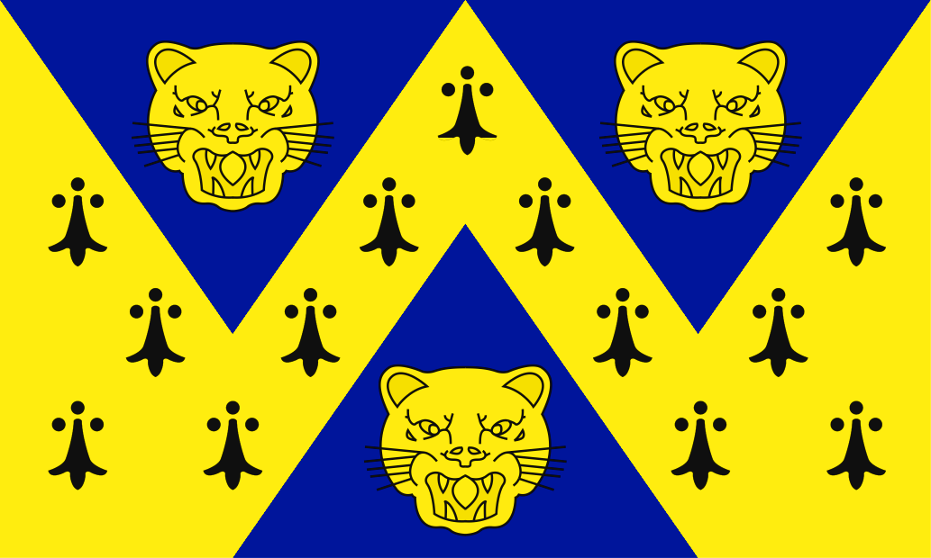
The Shropshire flag is a banner of the arms of the former Shropshire County Council. The leopards' faces, fondly referred to as loggerheads locally, are a traditional emblem for Shropshire and have historically evolved from the lions' heads on the Shrewsbury town arms which themselves were first recorded in 1623. Shropshire Day is celebrated on February 23rd, the feast day of St Milburga.

Shropshire Flag by the River Severn in Shrewsbury