
 Menu
MenuSearch the Gazetteer
Are the results not as expected? Modify your search term or change the scope to refine your search.
Results for a place that exactly matches ...
Roxburghshire
Roxburghshire, Scotland
Roxburghshire is an inland county. A jewel of the Middle Shires, it lies equally distant from the North Sea and the Solway Firth. Roxburghshire is an agricultural county of small villages.
Place Type: Historic County
Lat, Long: 55.472347,-2.503421
Grid Reference: NT682199
Country: Scotland
GBPNID: 305807
Entry Type: Main listing (P)
URL: https://gazetteer.org.uk/place/Roxburghshire,_305807
 Explore Roxburghshire on Wikishire
The Cheviots stretch from Northumberland into much of the east of Roxburghshire. Their highest ridges mark much of the border between the two counties. Roxburghshire's own county top being Auchope Cairn, a subsidiary summit of Cairn Hill, on the Northumberland border and on the flank of The Cheviot itself.
North and west of the Cheviots, much of the county is occupied by Teviotdale, the basin drained by the River Teviot and tributaries. The Teviot rises near Causeway Grain Head on the Dumfriesshire border and runs in a north-easterly direction for 37 miles until it sheds its waters into the growing Tweed at Kelso. The town of Hawick, distinctive for its many sandstone buildings with slate roofs, lies in the heart of Teviotdale. The town and royal burgh of Jedburgh stands on the Jed Water, a tributary of the River Teviot. It is dominated by the substantial ruins of Jedburgh Abbey, founded by King David I, still impressive in their shell.

Jedburgh Abbey
The Tweed enters Roxburghshire in the north, from Selkirkshire, and flows through the north-east of the county for 26 miles, serving as a border river with Berwickshire for some twelve miles before meeting the Tevoit at Kelso, and then flowing north-east into Berwickshire. Kelso is a quaint market town with its cobbled streets, elegant Georgian buildings and French style cobbled market square. The origins of the town lies in the creation of Kelso Abbey in 1128.
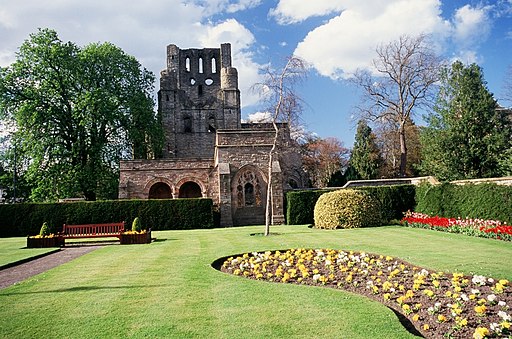
Kelso Abbey
Floors Castle, the seat of the Duke of Roxburghe, is an 18th century country house beside the Tweed north of Kelso. Smailholm Tower is a 15th century peel tower by Smailholm, around five miles west of Kelso. Its dramatic situation, atop a crag of Lady Hill, commands wide views over the surrounding countryside.

Floors Castle
The destroyed town and castle of Roxburgh lie on the narrow tongue of land between the Teviot and Tweed, just west of Kelso. English and Scots forces repeatedly captured and recaptured the town during the Scottish Wars of Independence. Its final recapture by the Scots in 1460 saw the town and castle destroyed. Nothing remains except some ruined segments of castle ramparts. Today's Roxburgh is a village on the Teviot a few miles away.
In the far north of the shire is the lovely Eildon and Leaderfoot National Scenic Area, beneath the Eildon Hills where the Leader meets the Tweed. On the Tweed lies Melrose, with the remains of Melrose Abbey. Nearby, at Newstead, is the Roman fort complex of Trimontium.

Site of the Roman Trimontium amphitheatre with the Victorian Leaderfoot viaduct in the background.
The south-west of the county is formed from Liddesdale, the valley of the Liddel Water, from the vicinity of Peel Fell to the point where Roxburghshire, Dumfriesshire and Cumberland meet. In this valley is Hermitage Castle, a massive H-shaped fortress of enormous strength, one of the oldest surviving castles in Scotland.

Hermitage Castle
After the Roman withdrawal in the 5th century AD, the area which later became Roxburghshire formed part of the kingdom of Strathclyde. The Anglo-Saxon kingdom of Northumbria held the region for four centuries until it was ceded to Scotland in 1018. The county appears to have originated in the 12th century with the creation of the sheriffdom of Roxburgh. The hereditary sheriffship of Roxburghshire was possessed by the family of Douglas until the abolition of heritable jurisdictions in the 18th century. King David I founded the Abbeys at Jedburgh and Kelso in his sweep of new monastic foundations, and Jedburgh in particular became a wealthy centre until the Reformation. The county was constantly fought over in the Middle Ages as part of the Anglo-Scottish Wars, before the border settled into roughly its modern form with the Treaty of York in 1237. The violence and lawlessness of these times gave rise to the Border Reivers, who raided the entire Border country without regard to their victims' nationality. During the 18th and 19th centuries woollen textile manufacture expanded the county’s economy, which has traditionally rested on livestock raising.
Place Type: Historic County
Lat, Long: 55.472347,-2.503421
Grid Reference: NT682199
Country: Scotland
GBPNID: 305807
Entry Type: Main listing (P)
URL: https://gazetteer.org.uk/place/Roxburghshire,_305807
Explore Roxburghshire on WikishireThe Cheviots stretch from Northumberland into much of the east of Roxburghshire. Their highest ridges mark much of the border between the two counties. Roxburghshire's own county top being Auchope Cairn, a subsidiary summit of Cairn Hill, on the Northumberland border and on the flank of The Cheviot itself.
North and west of the Cheviots, much of the county is occupied by Teviotdale, the basin drained by the River Teviot and tributaries. The Teviot rises near Causeway Grain Head on the Dumfriesshire border and runs in a north-easterly direction for 37 miles until it sheds its waters into the growing Tweed at Kelso. The town of Hawick, distinctive for its many sandstone buildings with slate roofs, lies in the heart of Teviotdale. The town and royal burgh of Jedburgh stands on the Jed Water, a tributary of the River Teviot. It is dominated by the substantial ruins of Jedburgh Abbey, founded by King David I, still impressive in their shell.

Jedburgh Abbey
The Tweed enters Roxburghshire in the north, from Selkirkshire, and flows through the north-east of the county for 26 miles, serving as a border river with Berwickshire for some twelve miles before meeting the Tevoit at Kelso, and then flowing north-east into Berwickshire. Kelso is a quaint market town with its cobbled streets, elegant Georgian buildings and French style cobbled market square. The origins of the town lies in the creation of Kelso Abbey in 1128.

Kelso Abbey
Floors Castle, the seat of the Duke of Roxburghe, is an 18th century country house beside the Tweed north of Kelso. Smailholm Tower is a 15th century peel tower by Smailholm, around five miles west of Kelso. Its dramatic situation, atop a crag of Lady Hill, commands wide views over the surrounding countryside.

Floors Castle
The destroyed town and castle of Roxburgh lie on the narrow tongue of land between the Teviot and Tweed, just west of Kelso. English and Scots forces repeatedly captured and recaptured the town during the Scottish Wars of Independence. Its final recapture by the Scots in 1460 saw the town and castle destroyed. Nothing remains except some ruined segments of castle ramparts. Today's Roxburgh is a village on the Teviot a few miles away.
In the far north of the shire is the lovely Eildon and Leaderfoot National Scenic Area, beneath the Eildon Hills where the Leader meets the Tweed. On the Tweed lies Melrose, with the remains of Melrose Abbey. Nearby, at Newstead, is the Roman fort complex of Trimontium.

Site of the Roman Trimontium amphitheatre with the Victorian Leaderfoot viaduct in the background.
The south-west of the county is formed from Liddesdale, the valley of the Liddel Water, from the vicinity of Peel Fell to the point where Roxburghshire, Dumfriesshire and Cumberland meet. In this valley is Hermitage Castle, a massive H-shaped fortress of enormous strength, one of the oldest surviving castles in Scotland.
.jpeg)
Hermitage Castle
After the Roman withdrawal in the 5th century AD, the area which later became Roxburghshire formed part of the kingdom of Strathclyde. The Anglo-Saxon kingdom of Northumbria held the region for four centuries until it was ceded to Scotland in 1018. The county appears to have originated in the 12th century with the creation of the sheriffdom of Roxburgh. The hereditary sheriffship of Roxburghshire was possessed by the family of Douglas until the abolition of heritable jurisdictions in the 18th century. King David I founded the Abbeys at Jedburgh and Kelso in his sweep of new monastic foundations, and Jedburgh in particular became a wealthy centre until the Reformation. The county was constantly fought over in the Middle Ages as part of the Anglo-Scottish Wars, before the border settled into roughly its modern form with the Treaty of York in 1237. The violence and lawlessness of these times gave rise to the Border Reivers, who raided the entire Border country without regard to their victims' nationality. During the 18th and 19th centuries woollen textile manufacture expanded the county’s economy, which has traditionally rested on livestock raising.