
 Menu
MenuSearch the Gazetteer
Are the results not as expected? Modify your search term or change the scope to refine your search.
Results for a place that exactly matches ...
Renfrewshire
Renfrewshire, Scotland
Renfrewshire is a maritime county which lies on the south bank of the Clyde, stretching from the southern Glasgow suburbs to the coast opposite Cowal.
Place Type: Historic County
Lat, Long: 55.834198,-4.583458
Grid Reference: NS383631
Country: Scotland
GBPNID: 305805
Entry Type: Main listing (P)
URL: https://gazetteer.org.uk/place/Renfrewshire,_305805
 Explore Renfrewshire on Wikishire
The main towns of Renfrewshire are in the east of the shire and along the coast. An area of south-west Glasgow, including Langside, Pollokshields and Shawlands, lies within Renfrewshire, as do suburban towns further to the south-west including Clarkston and Thornliebank.
Newton Mearns is a suburban village seven miles south-west of Glasgow city centre. Mearns Castle is a fifteenth-century tower house at the eastern edge of Newton Mearns. Capelrig House is an 18th-century Category A listed house in Newton Mearns. Barrhead, eight miles south-west of Glasgow, was once a major centre for manufacturing, but is now a popular residential commuter town for Glasgow and Paisley.
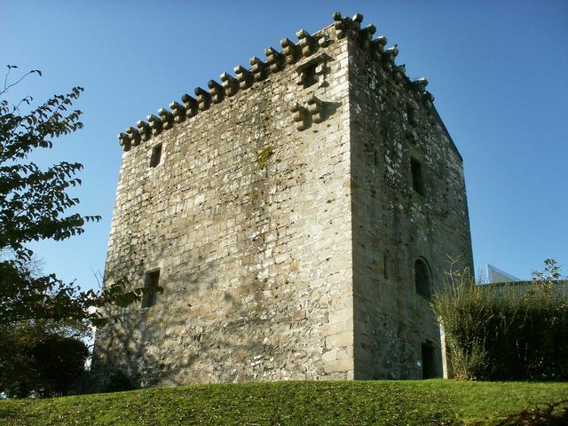
Mearns Castle
West of Glasgow is Paisley, the largest town in the county and formerly a centre of the weaving industry. The modern economy is based around public administration, higher education, retail and leisure. Paisley Abbey is a former Cluniac monastery, and current Church of Scotland parish kirk, located on the east bank of the White Cart Water in the centre of the town. Glasgow Airport is located on the town's northern edge.

Paisley Abbey interior
The county town, Renfrew, was a ship-building town on the Clyde. Today it primarily contains service sector businesses. It is called the "Cradle of the Royal Stewarts" for its early link with Scotland's former royal house. Nothing remains above ground of the former Renfrew Castle.

Greenock and Port Glasgow waterfront
Along the coast in the north-west of the county are Port Glasgow, Greenock and Gourock. Originally a fishing hamlet named Newark, Port Glasgow came about as a result of large ships being unable to navigate the Clyde to Glasgow. Shipbuilding, long the town's biggest industry, continues to this day. Newark Castle, close to the shore of the Clyde, dates to around 1484. Greenock is a port town which historically relied on shipbuilding, sugar refining and wool manufacturing. These have given way to service and financial industries. Greenock Custom House is considered one of the finest in Britain. Gourock was a popular seaside resort but today it is a residential town and a ferry port for Dunoon, Helensburgh and Kilgcreggan across the Clyde.

Greenock Custom House from quay
The village of Inverkip lies on the coast of the Firth of Cylde. The village was founded by monks from Paisley Abbey in 1170. The modern village is known for its large marina. To the south is Wemyss Bay, founded as a "marine village" in the early 19th century, though now largely a commuter village for Greenock and Glasgow. Wemyss Bay is the port for ferries to Rothesay on the Isle of Bute.

Wemyss Bay Pier
Above the coastal land the county consists of low moorland, rising to such modest hills as those of the Renfrewshire Heights. Only towards the Ayrshire border and that of Lanarkshire in the south-east are there any great heights and the county's surface is undulating rather than rugged. On the south-west towards Ayrshire the greatest hills are the Hill of Stake (standing at 1,713 feet; the county top), East Girt Hill (1,673 feet), Misty Law (1,663 feet) and Creuch Hill (1,446 feet). Much of the higher land in the centre is well wooded.

Misty Law in the Renfrewshire Heights
Strathgryffe is the only considerable valley in the shire. Strathgryffe extends from the Gryffe reservoirs to below Bridge of Weir, a distance of 10 miles. The scenery at its head is somewhat wild and bleak, but the lower reaches are pasture land.
The Killock Burn rises is a number of smaller headwaters in the gentle hills close to Neilston, and runs east-south-eastwards, creating in its lower reaches a small, lovely gorge known as Glenkillock, a wooded ravine bisecting the Fereneze Hills. The three waterfalls on the burn in Glenkillock have been compared with the Clyde Falls in miniature.
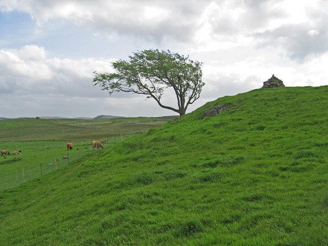
Cairn on the Fereneze Hills
Renfrewshire can trace its origin to Walter Fitzalan, the first High Steward of Scotland in the 12th century. Fitzalan fled Shropshire during "the Anarchy"; the civil war between the Empress Matilda and Stephen, in which Walter had supported Matilda, but when her cause was lost, Walter befriended her uncle, King David I of Scotland, and became, David's Dapifer or Steward. King David granted to Walter Fitzalan the lands of Strathgryfe, a district approximating to the shire. In 1163 Walter founded, first at Renfrew but shortly afterwards at Paisley, a house of monks of the Cluniac order drawn from the priory of Much Wenlock, in his native Shropshire. The monastery steadily grew and by 1219 became Paisley Abbey. Fitzalan's descendants eventually became the powerful House of Stewart. Walter Stewart, the Fifth High Steward of Scotland married Princess Marjory, daughter of Robert I, in 1315 and in 1371 their son was crowned Robert II, King of Scots. Robert III who succeeded, established the shire of Renfrew based on the royal burgh of Renfrew, the site of the castle of the House of Stewart. From this point onwards, the county has been closely tied to the monarchy and the heir apparent to the British monarch holds the title of Baron of Renfrew.
Place Type: Historic County
Lat, Long: 55.834198,-4.583458
Grid Reference: NS383631
Country: Scotland
GBPNID: 305805
Entry Type: Main listing (P)
URL: https://gazetteer.org.uk/place/Renfrewshire,_305805
Explore Renfrewshire on WikishireThe main towns of Renfrewshire are in the east of the shire and along the coast. An area of south-west Glasgow, including Langside, Pollokshields and Shawlands, lies within Renfrewshire, as do suburban towns further to the south-west including Clarkston and Thornliebank.
Newton Mearns is a suburban village seven miles south-west of Glasgow city centre. Mearns Castle is a fifteenth-century tower house at the eastern edge of Newton Mearns. Capelrig House is an 18th-century Category A listed house in Newton Mearns. Barrhead, eight miles south-west of Glasgow, was once a major centre for manufacturing, but is now a popular residential commuter town for Glasgow and Paisley.

Mearns Castle
West of Glasgow is Paisley, the largest town in the county and formerly a centre of the weaving industry. The modern economy is based around public administration, higher education, retail and leisure. Paisley Abbey is a former Cluniac monastery, and current Church of Scotland parish kirk, located on the east bank of the White Cart Water in the centre of the town. Glasgow Airport is located on the town's northern edge.

Paisley Abbey interior
The county town, Renfrew, was a ship-building town on the Clyde. Today it primarily contains service sector businesses. It is called the "Cradle of the Royal Stewarts" for its early link with Scotland's former royal house. Nothing remains above ground of the former Renfrew Castle.

Greenock and Port Glasgow waterfront
Along the coast in the north-west of the county are Port Glasgow, Greenock and Gourock. Originally a fishing hamlet named Newark, Port Glasgow came about as a result of large ships being unable to navigate the Clyde to Glasgow. Shipbuilding, long the town's biggest industry, continues to this day. Newark Castle, close to the shore of the Clyde, dates to around 1484. Greenock is a port town which historically relied on shipbuilding, sugar refining and wool manufacturing. These have given way to service and financial industries. Greenock Custom House is considered one of the finest in Britain. Gourock was a popular seaside resort but today it is a residential town and a ferry port for Dunoon, Helensburgh and Kilgcreggan across the Clyde.

Greenock Custom House from quay
The village of Inverkip lies on the coast of the Firth of Cylde. The village was founded by monks from Paisley Abbey in 1170. The modern village is known for its large marina. To the south is Wemyss Bay, founded as a "marine village" in the early 19th century, though now largely a commuter village for Greenock and Glasgow. Wemyss Bay is the port for ferries to Rothesay on the Isle of Bute.

Wemyss Bay Pier
Above the coastal land the county consists of low moorland, rising to such modest hills as those of the Renfrewshire Heights. Only towards the Ayrshire border and that of Lanarkshire in the south-east are there any great heights and the county's surface is undulating rather than rugged. On the south-west towards Ayrshire the greatest hills are the Hill of Stake (standing at 1,713 feet; the county top), East Girt Hill (1,673 feet), Misty Law (1,663 feet) and Creuch Hill (1,446 feet). Much of the higher land in the centre is well wooded.

Misty Law in the Renfrewshire Heights
Strathgryffe is the only considerable valley in the shire. Strathgryffe extends from the Gryffe reservoirs to below Bridge of Weir, a distance of 10 miles. The scenery at its head is somewhat wild and bleak, but the lower reaches are pasture land.
The Killock Burn rises is a number of smaller headwaters in the gentle hills close to Neilston, and runs east-south-eastwards, creating in its lower reaches a small, lovely gorge known as Glenkillock, a wooded ravine bisecting the Fereneze Hills. The three waterfalls on the burn in Glenkillock have been compared with the Clyde Falls in miniature.

Cairn on the Fereneze Hills
Renfrewshire can trace its origin to Walter Fitzalan, the first High Steward of Scotland in the 12th century. Fitzalan fled Shropshire during "the Anarchy"; the civil war between the Empress Matilda and Stephen, in which Walter had supported Matilda, but when her cause was lost, Walter befriended her uncle, King David I of Scotland, and became, David's Dapifer or Steward. King David granted to Walter Fitzalan the lands of Strathgryfe, a district approximating to the shire. In 1163 Walter founded, first at Renfrew but shortly afterwards at Paisley, a house of monks of the Cluniac order drawn from the priory of Much Wenlock, in his native Shropshire. The monastery steadily grew and by 1219 became Paisley Abbey. Fitzalan's descendants eventually became the powerful House of Stewart. Walter Stewart, the Fifth High Steward of Scotland married Princess Marjory, daughter of Robert I, in 1315 and in 1371 their son was crowned Robert II, King of Scots. Robert III who succeeded, established the shire of Renfrew based on the royal burgh of Renfrew, the site of the castle of the House of Stewart. From this point onwards, the county has been closely tied to the monarchy and the heir apparent to the British monarch holds the title of Baron of Renfrew.