
 Menu
MenuSearch the Gazetteer
Are the results not as expected? Modify your search term or change the scope to refine your search.
Results for a place that exactly matches ...
Nottinghamshire
Nottinghamshire, England
 Nottinghamshire in an inland county which stretches from the heart of the Midlands to the edge of Yorkshire. It is low-lying, rarely reaching 600 feet above sea level. The River Trent crosses southern Nottinghamshire as a broad stream. Nottingham itself has at its heart a mediæval castle on a sandstone hill overlooking and commanding the Trent. The market town of Hucknall, final resting place of Lord Byron, lies north-east of Nottingham. From Nottingham, the Trent continues north-west to Newark-on-Trent. The town grew around Newark Castle and a large marketplace, now lined with historic buildings. Nearby Southwell is home to a Cathedral of great architectural interest. The ancient lands of Sherwood Forest, famous as the legendary haunt of Robin Hood, reach from the edge of Nottingham northwards towards Yorkshire. Though less extensive than in former days, the remaining forest is impressive nevertheless. Much of north-western Nottinghamshire is known as "The Dukeries", so named as the location of several great estates, four of them the seats of Dukes. This area is better known now for the mining villages and industrial development that grew with the opening up of the Dukeries Coalfield. The major towns are Mansfield, Sutton-in-Ashfield and Worksop, "the capital of the Dukeries". Creswell Crags is an enclosed limestone gorge on the border between Nottinghamshire and Derbyshire. The cliffs contain caves that were occupied during the last Ice Age and which contain the northernmost cave art in Europe.
Place Type: Historic County
Lat, Long: 53.133797,-0.949861
Grid Reference: SK703601
Country: England
GBPNID: 305833
Entry Type: Main listing (P)
URL: https://gazetteer.org.uk/place/Nottinghamshire,_305833
 Explore Nottinghamshire on Wikishire
The City of Nottingham itself is one of the largest of the Midland towns. At its heart is a mediæval castle on a sandstone hill overlooking and commanding the Trent. The sandstone of Nottingham and much of the county is peppered with caves. The hill on which Nottingham Castle is built has spacious caves beneath it and evidence of long habitation. The mediæval inn "The Trip to Jerusalem" is built into a cave, and higher up the Trent there were cave-dwellers into the twentieth century. The market town of Hucknall, final resting place of Lord Byron and his estranged daughter, the mathematician Ada Lovelace, lies north-east of Nottingham. Byron's ancestral home, Newstead Abbey, lies north of the town.

Rock-cut houses south of Nottingham Castle.
From Nottingham, the Trent continues north-west to Newark-on-Trent, close to the eastern border with Lincolnshire. The origins of Newark are possibly Roman as it lies on an important Roman road, the Fosse Way. The town grew around Newark Castle, now ruined, and a large marketplace, now lined with historic buildings. The Fosse Way enters Nottinghamshire south of Newark and departs the county north-east of the town, part of its long course from Exeter to Lincoln. It is remarkably almost devoid of villages along its Nottinghamshire section. West of Newark is Southwell, home of a Cathedral of great architectural interest.

Southwell Minster
After Newark, the Trent turns north and flows across the east of the county. Cromwell Weir marks the tidal extent of the river. The now tidal river meanders across a wide floodplain, at the edge of which are located riverside villages such as Carlton and Sutton on Trent, Besthorpe and Girton. Close to Dunham-on-Trent the river becomes a long stretch of the county border. Littleborough is the site of the Roman town of Segelocum, where a Roman road once crossed the river. The Trent finally heads into Lincolnshire near Misterton. This eastern part of the county is largely agricultural with no towns.
The ancient lands of Sherwood Forest reach from the edge of Nottingham northwards towards Yorkshire. The woodland itself is less extensive than in former days but the remaining forest is impressive nevertheless, particularly between Ollerton and Worksop. Sherwood is famous as the legendary haunt of Robin Hood.
.jpg)
Sherwood Forest
Much of north-western Nottinghamshire is the area known as "The Dukeries", so named in jest as the place where several great estates lay close together, four of them the country seats of Dukes (Clumber House, Thoresby Hall, Welbeck Abbey, Worksop Manor). This part of Nottinghamshire is better known now for the mining villages and industrial development that grew with the opening up of the Dukeries Coalfield. Nevertheless, several of the great parks remain as a feature of the green landscape. Though the mines are now all closed, north-western Nottinghamshire was shaped by the mining industry. The mines created villages and towns which stretch in a belt up towards the Yorkshire boundary. The major towns in this part are Mansfield, Sutton-in-Ashfield and Worksop, "the capital of the Dukeries".

The Walled Garden at Clumber Park
Away from the coal field, at the centre of the north, Retford remained primarily a rural market town, now with large service and light industry sectors.
Creswell Crags is an enclosed limestone gorge on the border between Nottinghamshire and Derbyshire. The cliffs in the ravine contain several caves that were occupied during the last Ice Age, between around 43,000 and 10,000 years ago. The caves contain the northernmost cave art in Europe.
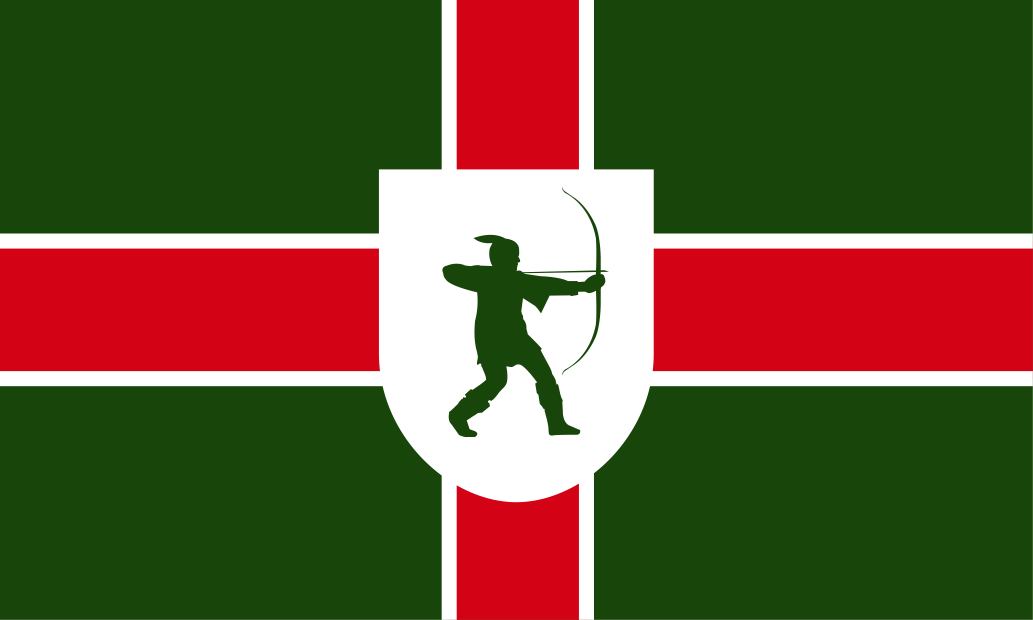
Roman settlement in the area that became Nottinghamshire was concentrated along the Fosse Way. The county was settled by the English around the 5th century, and became part of the Kingdom of the Mercians. The county's name derives from its county town, whose name in turn is said to come from an Anglo-Saxon chieftain, Snotta. The earliest surviving written reference to the county by name (Snotingahamscir) is from 1016. After the Danish invasion in the 9th century, Nottingham became one of the five Danish boroughs. Coal mining in Nottinghamshire dates to the 13th century, but expanded with the Industrial Revolution, which also saw the development of textile manufacturing and other industries in the west of the county. The Nottinghamshire Flag includes a white-fimbriated red St George's Cross on a green background, and a green silhouette of James Woodford's bronze statue of Robin Hood on a white shield.