
 Menu
MenuSearch the Gazetteer
Are the results not as expected? Modify your search term or change the scope to refine your search.
Results for a place that exactly matches ...
Northumberland
Northumberland, England
 Northumberland, a maritime county in the far north-east of England, is a county of contrasts. Much of the county comprises richly dramatic scenery, from the open coast to the wild interior. Inland, Northumberland is a county of fells and dales, much of it within the Northumberland National Park. Along the jagged and stony North Sea coast, from Berwick-upon-Tweed to Tynemouth, numerous castles and religious sites bear witness to the county’s lengthy and often violent history. In contrast, the Tyne and Blyth valleys in the south of the county are densely populated urban areas, including Newcastle upon Tyne, Wallsend and North Shields – an area with a unique economic, industrial and cultural heritage.
Place Type: Historic County
Lat, Long: 55.329876,-1.904374
Grid Reference: NU061039
Country: England
GBPNID: 305832
Entry Type: Main listing (P)
URL: https://gazetteer.org.uk/place/Northumberland,_305832
 Explore Northumberland on Wikishire
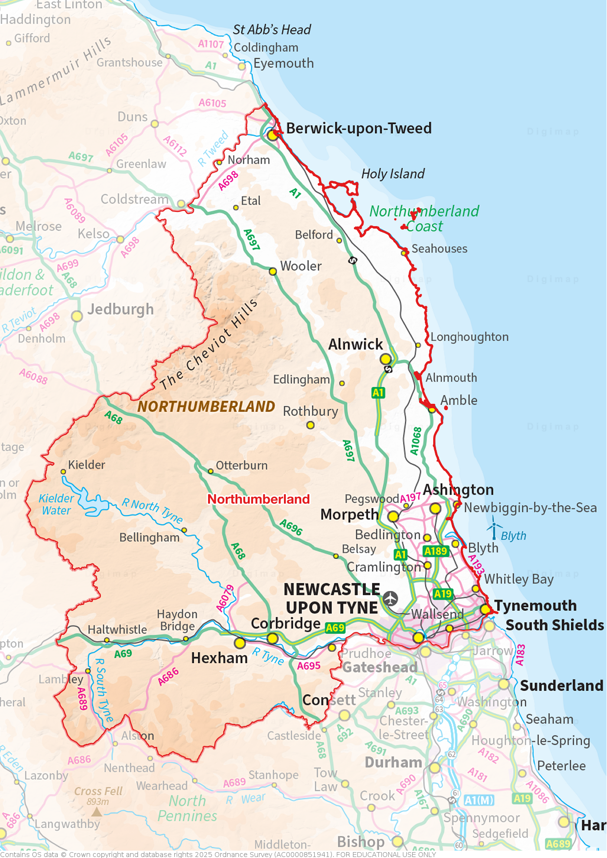
Newcastle upon Tyne is one Great Britain's major cities. Grand. Impressive. Distinctive. In large parts, Newcastle still retains a mediæval street layout. Narrow alleys or ‘chares’, most of which can only be traversed by foot, still exist in abundance. Stairs from the riverside to higher parts of the city centre and the extant Castle Keep, originally recorded in the 14th century, remain in places. The Tyne Gorge, between Newcastle on the north bank in Northumberland and Gateshead on the south bank in County Durham, is famous for a series of dramatic bridges, including the Tyne Bridge of 1928 which was built by Dorman Long, and Robert Stephenson’s High Level Bridge of 1849, the first road/rail bridge in the world. Between these two is the Tyne Swing Bridge, opened in 1876.

The Tyne Swing Bridge with the Castle Keep behind, Newcastle upon Tyne
To the east of Newcastle is Wallsend, the site of the Roman fort of Segedunum, the fort protecting the eastern end of Hadrian's Wall. The town has a proud coal mining and ship building heritage. The Wallsend Boys Club has produced many famous footballers. Wallsend is the home town of the musician Sting whose song All This Time was inspired by the town.

Remains of Hadrian's Wall in Wallsend
The Tyne Cyclist and Pedestrian Tunnels, opened in 1951, run under the River Tyne from Howdon (east of Wallsend) in Northumberland to Jarrow in County Durham. The cyclist tunnel was Britain’s first purpose-built cyclist tunnel. The county border is marked within the tunnels.
.jpg)
County border sign in the Tyne Pedestrian Tunnel
North Shields lies further east, close to the mouth of the Tyne. The town's name derives from the Middle English schele meaning "shieling" (temporary sheds or huts, used by fishermen in this case). The town is still known for fishing and the trades associated with seafaring.
The coast begins at Tynemouth, a major port. Tynemouth Castle stands on a rocky headland. The moated castle-towers, gatehouse and keep are combined with the ruins of the Benedictine priory where the early kings of Northumbria were buried.

Tynemouth Castle and Priory
North of the Tyne, up to the port-town of Blyth, are a number of coastal towns, including the famous resort of Whitley Bay. The holiday industry emerged in the area followed the opening of the North Tyne Loop Railway in 1882. The Spanish City, a leisure complex first opened in 1910, has a 180-ft long Renaissance-style frontage and is known for its distinctive dome. The Whitley Bay Pleasure Gardens (sadly closed in 1999) was a famous fairground. St Mary’s Island is the site of a lighthouse, one of the town’s landmarks.

The Spanish City, Whitley Bay
Inland from the coast and north of the urban area along the Tyne are several small towns. Cramlington is a new town begun in the 1960s. Bedlington was historically constituted a liberty of the Bishop of Durham. Morpeth grew at an important crossing point of the River Wansbeck. Morpeth Town Hall dates from 1718 and was designed by Sir John Vanbrugh. Ashington is a former coal mining town, the birthplace of footballer Jackie Milburn.
_-_geograph.org.uk_-_851954.jpg)
The Vicar's Pele, Ponteland
To the north-west of Newcastle upon Tyne is Ponteland, notable for the old bridge from which it takes its name and a ruined pele tower. The village of Belsay, five miles from Ponteland, is the location of both Belsay Castle (EH), a ruined 14th-century mediæval castle, and Belsay Hall (EH), the 19th-century grand mansion built to replace it. The town of Prudhoe lies 18 miles west of Newcastle upon Tyne. Prudhoe Castle is a Norman castle, for a long time involved in the border wars.

Belsay Castle
Blyth has been a port since the 12th century, though the modern town grew from the 18th century alongside the coal mining and shipbuilding industries. The port still thrives. The Quayside contains a sculpture commemorating the industry that once thrived there. Newbiggin-by-the-Sea claims the longest promenade in Northumberland. The promenade becomes a prime location for birders watching the North Sea seabird migratory passage each spring and autumn.

The Quayside at Blyth
North of Blyth is the undisturbed rural Northumberland seacoast. The small town of Amble lies at the mouth of the River Coquet. Elsewhere, the coastline is generally low-lying and rocky, with numerous little bays and modest villages. The ruins of Dunstanburgh Castle, the largest in Northumberland, stand on a headland between the villages of Craster and Embleton. Warkworth Castle is a ruined mediæval building standing in a loop of the River Coquet, a mile from the coast.

Dunstanburgh Castle
In the north of the county are sites resonating with history: Bamburgh Castle sits perched on a precipitous rock which was the first seat of the Bernician kings. Opposite Bamburgh are the Farne Islands stretching into the North Sea and well known for their abundant birdlife, and north of them the largest and most famous is Lindisfarne or Holy Island, which was the first Christian missionary centre in Northumbria. Lindisfarne Priory (EH) was founded in 634 and dissolved at the Dissolution. Lindisfarne Castle (NT) is a 16th-century castle, much altered by Sir Edwin Lutyens in 1901 to serve as a magnificent stately home for Edward Hudson.

Lindisfarne castle
Norham Castle (EH) overlooks the River Tweed, the border between Northumberland and Roxburghshire. The castle saw much action during the wars between the two kingdoms and in times of peace it was active in the struggle to keep down the border reivers.

Norham Castle
Alnwick is a small market town mainly known as the location of Alnwick Castle, seat of the Dukes of Northumberland. It was a staging post on the Great North Road between London and Edinburgh. Edlingham Castle is a small castle ruin standing in a valley to the west of Alnwick.

Alnwick Castle
Berwick-upon-Tweed is a sturdy town on the north bank of the Tweed. It was once a wealthy port and the county town of Berwickshire and there is still debate about whether it belongs to Northumberland or to Berwickshire. The ruined Berwick Castle (EH) was founded in the 12th century by the Scottish King David I. The castle’s location in the hotly disputed border country between England and Scotland made it one of the most important strongholds in the British Isles, and it enjoyed an eventful history. Tweedmouth lies south of the Tweed and separated from Berwick by the 15-arched Old Bridge, built of local sandstone in 1610.

Berwick-upon-Tweed lighthouse
Inland, Northumberland is a county of fells and dales, part of the Pennine chain. The fells fill most of the county, bleak and beautiful and largely unpopulated. In the north of the county are the Cheviot Hills. The Cheviot (2,674 feet), close to the Roxburghshire border, is the county top. A great deal of this high moorland is protected in the Northumberland National Park. Castles and peel towers abound; reminders of more lawless times. Cartington Castle is a ruinous, partly restored mediæval castle in the village of Cartington, looking down on the River Coquet. Chillingham Castle, a mediæval castle in the village of Chillingham, was the seat of the Grey (Baron Grey of Werke) and Bennet (Earls of Tankerville) families from the 15th century until the 1980s. Elsdon Castle, near Rothbury, is the best preserved mediæval motte and bailey castle site in Northumberland. Etal Castle is a ruined mediæval fortification in the village of Etal, built around 1341 by Robert Manners.
_(geograph_3470767).jpg)
Cartington Castle
Hexham is an ancient market town in the south-west of the county, south of the River Tyne. The town is dominated by Hexham Abbey, whose stones incorporate an early Anglo-Saxon crypt from the monastery founded by Wilfrid in 674. Other highlights of the town are the Moot Hall, the covered market, and the Old Gaol.
.jpg)
The Old Gaol, Hexham
Near to Hexham is the village of Corbridge, northernmost town of Roman ‘’Britannia’’. Corbridge Roman Site (EH) contains the remains of the Roman fort. The village is also the site of one of the earliest churches standing in Britain: the 7th-century St Andrew is one of the finest examples of early Anglo-Saxon architecture that has come down to us. Aydon Castle (EH) is a fortified manor house near the town.

Corbridge Roman site
Haltwhistle lies to the west of Hexham , close to Hadrian’s Wall and to the Cumberland border. Nearby is Bellister Castle (NT), a castellated 19th-century mansion house attached to the ruinous remains of a 14th-century tower house.

Bellister Castle
The Romans constructed Hadrian’s Wall from the River Tyne to the Solway Firth around AD 122. Hadrian’s Wall crosses the south of Northumberland east to west, from Wallsend out to the Solway coast in Cumberland, a remnant but an impressive one of the great Roman wall with forts and mile-castles dotted along it.
_-_geograph.org.uk_-_3470946.jpg)
Hadrian's Wall near Haltwhistle
After the Roman withdrawal, the Angles gradually gained control of the region. King Ida built the fortress at Bamburgh in 547 and founded the kingdom of Bernicia. Aethelfrith the Destroyer, his grandson, annexed the neighbouring kingdom of Deira in 605 and established the kingdom of Northumbria between the Firth of Forth and the River Humber. Lindisfarne was the centre for the spread of Christianity throughout this kingdom. The Danes conquered Northumberland in the 9th century, the land north of the River Tweed being lost to the Scots. Following the Conquest, the Normans built castles to defend against invasions from Scotland and Scandinavia. Northumberland’s history until the union of the crowns (1603) is a record of continuous border warfare.
_-_geograph.org.uk_-_3470997.jpg)
Lindisfarne Priory
In mediæval times, Northumberland prospered from the production and export of wool and hides. The coal trade expanded from the 13th century. Shipbuilding grew to become a major industry, as did glassmaking and chemical industries. During the late 20th century the heavy industries of the Tyne and Blyth valleys declined, and coal mining ceased.

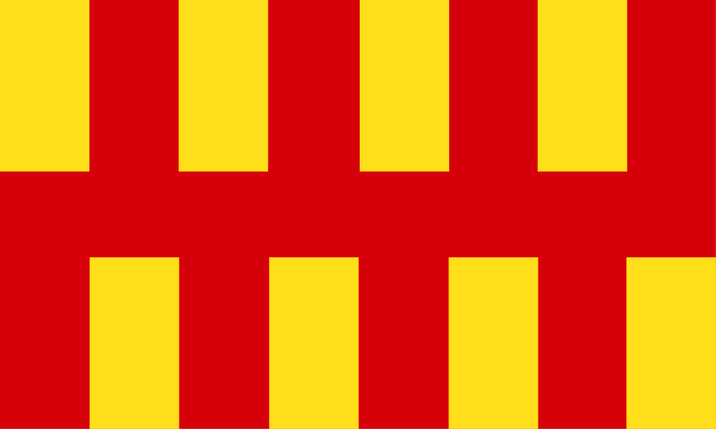
Northumberland flag at Swarland
The Northumberland flag is a banner of the arms of the former Northumberland County Council. The shield of arms is in turn based on the arms mediæval heralds had attributed to the Kingdom of Bernicia. The Bernician arms were fictional but inspired by Bede’s brief description of a flag used on the tomb of St Oswald in the 7th century. The county day is 5th August, the feast day of Oswald of Northumbria.