
 Menu
MenuSearch the Gazetteer
Are the results not as expected? Modify your search term or change the scope to refine your search.
Results for a place that exactly matches ...
Montgomeryshire
Montgomeryshire, Wales
Montgomeryshire (Sir Drefaldwyn) is a mountainous county in mid-Wales, most of the county being in the heart of the Cambrian Mountains. The county extends to the Dovey estuary in the far west. Offa’s Dyke runs along the county's eastern border. The River Severn rises in Montgomeryshire and flows through much of the south and west of the county. Once part of the kingdom of Powys, the area was under the marcher lordships from around 1090 to 1536, when the county was formally created. A string of Norman castles lie in the east of the county, including Powis Castle near Welshpool and Montgomery Castle in the county town.
Portrait of Montgomeryshire
Place Type: Historic County
Alternative name(s): Sir Drefaldwyn
Lat, Long: 52.610354,-3.386946
Grid Reference: SJ061023
Country: Wales
GBPNID: 305784
Entry Type: Main listing (P)
URL: https://gazetteer.org.uk/place/Montgomeryshire,_305784
 Explore Montgomeryshire on Wikishire
The River Severn rises in the far south-west of Montgomeryshire, on the slopes of Plynlimon, and flows through much of the the south and west of the county. The Hafren Forest covers the upper reaches of the Severn, and consists of mainly pine and spruce trees. Ten miles dowstream is the town of Llanidloes. Llanidloes takes its name from the early 7th century Celtic Saint Idloes. The town was given a charter in 1289 but existed at least 400 years before that.
From Llanidloes, the Severn flows north-eastwards across the south of the county. At Caersws it is joined by the Garno and Trannon. The village is the location of two Roman forts. Further east the Severn flows through Newtown, the largest town in Montgomeryshire. The town is best known as the birthplace of the industrialist Robert Owen in 1771 with his former house now being a museum. Newtown is also the home of Oriel Davies Gallery, a major public gallery.

Roman Fort at Caersws
Dolforwyn Castle is a mediæval castle above the village of Abermule, on a wooded ridge commanding excellent views of the upper Severn Valley. The fortification was established by Llywelyn ap Gruffudd in the late 13th century, a fine example of native Welsh castle design.

Dolforwyn Castle
The town of Montgomery lies a mile south of the Severn, close to the Shropshire border. The town is named after the founder of its castle, Roger de Montgomery, a key supporter of William the Conqueror. Montgomery Castle was originally built as a motte and bailey on Roger's order between 1071 and 1074. The castle was rebuilt in stone from 1223. The town is in a place with origins much older: an Iron Age hill fort stands on the edge of the town. Other attractions include the Offa's Dyke Path, the Robber's Grave and the town wall.

Montgomery Castle from Offa's Dyke
Near the Shropshire border, the Severn turns northwards and flows past Welshpool, a town with much fine Georgian architecture. A little to the south lies Powis Castle, seat of the Earl of Powis.

Powis Castle
The Severn then flows to the north of Breidden Hill, an extinct volcanic hill with fine views across Wales and the Shropshire Plain. The river finally leaves Montgomeryshire in the north-east near Crew Green, heading east towards Shrewsbury.
The western part of Montgomeryshire reaches out toward the coast at the Dyfi estuary, a wedge between Merionethshire and Cardiganshire, but ends just above that water. It is in the Dyfi valley that the town of Machynlleth lies. The town was the seat of Owain Glyndŵr's Parliament in 1404. The Centre for Alternative Technology lies outside the town.

Senedd-dy (Owain Glyndwr's Parliament House), Machynlleth
Mathrafal Castle is a site on the banks of the River Banwy, just above its confluence with the river Vyrnwy, about three miles north-east of Llanfair Caereinion. Mathrafal is the original capital of the Kingdom of Powys. After the division of Powys in 1160 it became the capital of the southern portion which eventually became known as Powys Wenwynwyn. The remains comprise a compound surrounded by a bank and outer ditch on three sides, the fourth side being the river. Little remains of the original walls.
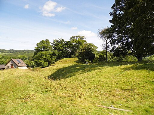
Mathrafal
In the far north of the county is Llanfyllin in a valley by the Berwyn Mountains, close to the Denbighshire border. The town is known for its holy well, dedicated to Saint Myllin who baptised people at Fynnon Coed y Llanin. Lake Vyrnwy is a huge Victorian reservoir of 1,200 acres built to supply water to Liverpool. The lake and the land surrounded it is a designated national nature reserve and a popular spot with bird-watchers, cyclists and hikers. The county top is Moel Sych (2,713 feet), the point where Montgomeryshire, Merionethshire and Denbighshire meet.
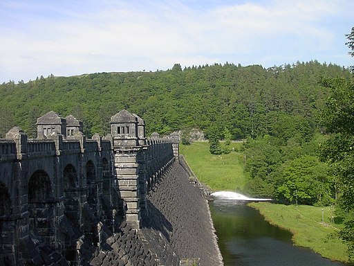
Lake Vyrnwy dam
The county is named after its county town, Montgomery. Although the county is a creation of the Laws in Wales Act 1535, it is of ancient origin, its borders corresponding roughly to the mediæval kingdom of Powys Wenwynwyn.
Portrait of Montgomeryshire
Place Type: Historic County
Alternative name(s): Sir Drefaldwyn
Lat, Long: 52.610354,-3.386946
Grid Reference: SJ061023
Country: Wales
GBPNID: 305784
Entry Type: Main listing (P)
URL: https://gazetteer.org.uk/place/Montgomeryshire,_305784
Explore Montgomeryshire on WikishireThe River Severn rises in the far south-west of Montgomeryshire, on the slopes of Plynlimon, and flows through much of the the south and west of the county. The Hafren Forest covers the upper reaches of the Severn, and consists of mainly pine and spruce trees. Ten miles dowstream is the town of Llanidloes. Llanidloes takes its name from the early 7th century Celtic Saint Idloes. The town was given a charter in 1289 but existed at least 400 years before that.
From Llanidloes, the Severn flows north-eastwards across the south of the county. At Caersws it is joined by the Garno and Trannon. The village is the location of two Roman forts. Further east the Severn flows through Newtown, the largest town in Montgomeryshire. The town is best known as the birthplace of the industrialist Robert Owen in 1771 with his former house now being a museum. Newtown is also the home of Oriel Davies Gallery, a major public gallery.

Roman Fort at Caersws
Dolforwyn Castle is a mediæval castle above the village of Abermule, on a wooded ridge commanding excellent views of the upper Severn Valley. The fortification was established by Llywelyn ap Gruffudd in the late 13th century, a fine example of native Welsh castle design.
_27.jpg)
Dolforwyn Castle
The town of Montgomery lies a mile south of the Severn, close to the Shropshire border. The town is named after the founder of its castle, Roger de Montgomery, a key supporter of William the Conqueror. Montgomery Castle was originally built as a motte and bailey on Roger's order between 1071 and 1074. The castle was rebuilt in stone from 1223. The town is in a place with origins much older: an Iron Age hill fort stands on the edge of the town. Other attractions include the Offa's Dyke Path, the Robber's Grave and the town wall.

Montgomery Castle from Offa's Dyke
Near the Shropshire border, the Severn turns northwards and flows past Welshpool, a town with much fine Georgian architecture. A little to the south lies Powis Castle, seat of the Earl of Powis.

Powis Castle
The Severn then flows to the north of Breidden Hill, an extinct volcanic hill with fine views across Wales and the Shropshire Plain. The river finally leaves Montgomeryshire in the north-east near Crew Green, heading east towards Shrewsbury.
The western part of Montgomeryshire reaches out toward the coast at the Dyfi estuary, a wedge between Merionethshire and Cardiganshire, but ends just above that water. It is in the Dyfi valley that the town of Machynlleth lies. The town was the seat of Owain Glyndŵr's Parliament in 1404. The Centre for Alternative Technology lies outside the town.

Senedd-dy (Owain Glyndwr's Parliament House), Machynlleth
Mathrafal Castle is a site on the banks of the River Banwy, just above its confluence with the river Vyrnwy, about three miles north-east of Llanfair Caereinion. Mathrafal is the original capital of the Kingdom of Powys. After the division of Powys in 1160 it became the capital of the southern portion which eventually became known as Powys Wenwynwyn. The remains comprise a compound surrounded by a bank and outer ditch on three sides, the fourth side being the river. Little remains of the original walls.

Mathrafal
In the far north of the county is Llanfyllin in a valley by the Berwyn Mountains, close to the Denbighshire border. The town is known for its holy well, dedicated to Saint Myllin who baptised people at Fynnon Coed y Llanin. Lake Vyrnwy is a huge Victorian reservoir of 1,200 acres built to supply water to Liverpool. The lake and the land surrounded it is a designated national nature reserve and a popular spot with bird-watchers, cyclists and hikers. The county top is Moel Sych (2,713 feet), the point where Montgomeryshire, Merionethshire and Denbighshire meet.

Lake Vyrnwy dam
The county is named after its county town, Montgomery. Although the county is a creation of the Laws in Wales Act 1535, it is of ancient origin, its borders corresponding roughly to the mediæval kingdom of Powys Wenwynwyn.