
 Menu
MenuSearch the Gazetteer
Are the results not as expected? Modify your search term or change the scope to refine your search.
Results for a place that exactly matches ...
Merionethshire
Merionethshire, Wales
 Merionethshire (Meirionnydd) is a maritime county in north Wales. The county is a shire of mountain and coast; the coastland is perhaps best known to visitors, but the heartland in the mountains is a place of rough beauty. Merionethshire is one of the strongest Welsh-speaking parts of Wales.
Place Type: Historic County
Alternative name(s): Sir Feirionnydd, Meirionnydd
Lat, Long: 52.784035,-3.830249
Grid Reference: SH766222
Country: Wales
GBPNID: 305787
Entry Type: Main listing (P)
URL: https://gazetteer.org.uk/place/Merionethshire,_305787
 Explore Merionethshire on Wikishire
The shire is washed by the gulf of the Irish Sea known as Cardigan Bay. The coastline consists alternately of cliffs and long stretches of sand and dunes. At the southernmost end lies the Dyfi estuary. The resorts of Aberdovey and Tywyn are known for their fine beaches. In St Cadfan's church in Tywyn can be found the St Cadfan's Stone dating from the 8th or 9th century and inscribed with the oldest known written Welsh. Barmouth is a holiday resort standing on the open sea and the broad estuary of the River Mawddach. The Barmouth Bridge stretches half a mile across the waters. The busy harbour plays host to the annual Three Peaks yacht race.
.jpg)
Aberdovey
Further north, hanging over the coast is the tiny town of Harlech, dominated by the remains of the Castle. Little more than a shell now, Harlech Castle (Cadw) served its turn from King Edward I to King Charles I, and it inspired the famous song. The county's coast runs north to the great inlet formed by the estuaries of the River Dywryd and River Glaslyn, the latter being the border with Caernarfonshire. On the headland between the estuaries lies the famous Portmeirion Italianate village, designed and built by Sir Clough Williams-Ellis between 1925 and 1975.

Harlech Castle
Away from the sea the county is the most mountainous in Wales. Much of the Snowdonia National Park lies in the county. The town of Blaenau Ffestiniog was once a centre of the Welsh slate mining industry. The Ffestiniog Railway is a narrow-gauge heritage railway which runs on a single line from Blaenau Ffestiniog 13 miles down to Dolgellau. At nearby Llan Ffestiniog are the Rhaeadr Cynfal waterfalls and the Tolmen-y-Mur Roman fort and amphitheatre.

Llechwedd Slate Quarry, Blaenau Ffestiniog
Amongst the hills, in the south of the county, is Dolgellau, the centre of a minor gold rush in the 19th century. A local goldmine still supplies the gold for royal weddings. Cymer Abbey is a ruined Cistercian abbey near the village of Llanelltyd, just north of Dolgellau. South of the town is Cadair Idris (2,930 feet), one of the most popular of the challenging mountains in Wales for walkers and hikers. Its shape and beauty are richly evocative of the wild landscape over which it presides. A prominent ridge stretches from Dolgellau to Bala in the north-east of the county. The county top, Aran Fawddwy (2,969 feet), lies on this ridge.

Aran Fawddwy
Castell y Bere (Cadw) is a ruined castle atop a hill in the south of the county near Llanfihangel-y-pennant. The castle was first built by Llywelyn the Great in the 1220s, a stone castle intended to defend the south-west part of the princedom of Gwynedd. In 1282 war with Edward I of England resulted in the death of Llywelyn's grandson, Llywelyn ap Gruffudd, and Castell y Bere fell to Edward's forces. In 1294 the Welsh leader Madoc ap Llywelyn mounted a major revolt and the castle was besieged and apparently burnt since when it has been a ruin.

Castell y Bere
In the north-west of the county, in a glacial valley, lies the great Bala Lake. The waters of the lake are famously deep and clear. The town of Bala sits at the north end, where the Rive Dee flows from the lake.
Merionethshire stretches further to the north-east, a great tail of the county cutting into Denbighshire. The town of Corwen is best known for its connections with Owain Glyndŵr, who was proclaimed Prince of Wales from his nearby manor of Glyndyfrdwy. A bronze statue of the prince stands in the town Square.
.jpg)
Owain Glyndwr statue, Corwen
Rug Chapel (Cadw), just outside Corwen, is one of few 17th century churches to avoid the ‘restorers’ of the Victorian Gothic revival. It was the private chapel of Colonel William Salesbury, affectionately known as ‘Hen Hosanau Gleision’ (Old Blue Stockings). A staunch Royalist he continues to pray here in high church splendour. The chapel is plain and unremarkable to external view, but inside every surface is a riot of colour or extravagant decoration. Fantastic carved animals adorn the walls and benches – scaly dragons, serpents and other strange whimsical monsters. The magnificent carved roof is painted in a glorious flowing floral design, guarded over by four cut-out wooden angels.

Rug Chapel (Capel y Rug)
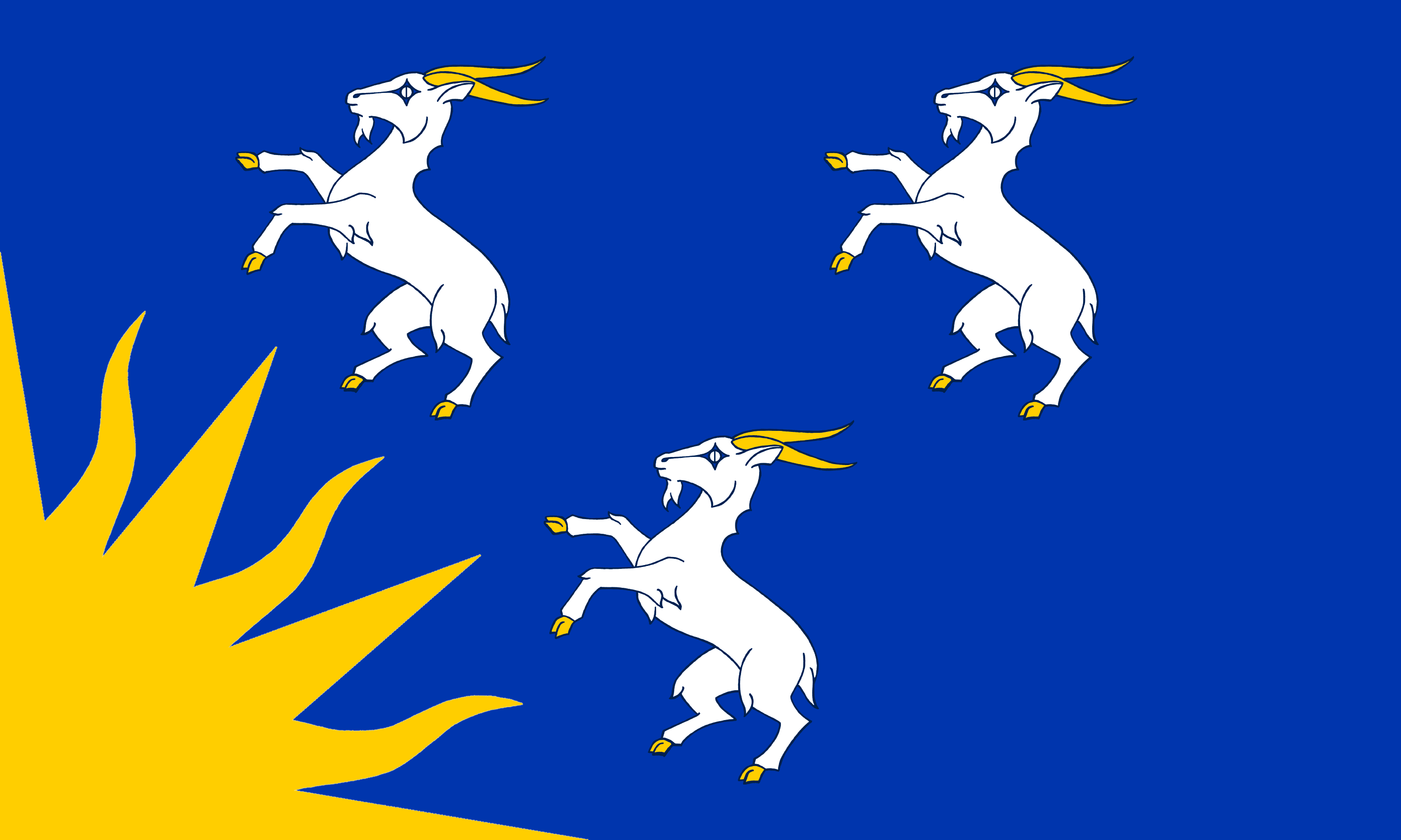
Merionethshire's name, in legend and possibly in fact, is from Meirion, a grandson of the mighty chief Cunedda who ruled this corner of Britain in late Roman or sub-Roman times. The county was formed in 1284 under the terms of the Statute of Rhuddlan from the Cantrefi of Meirionnydd, Dunoding (but only the larger Ardudwy commote), Penllyn and The Lordship of Dinmael. Merioneth was an important part of the Welsh slate industry in the nineteenth and twentieth centuries, with major quarrying centres at Blaenau Ffestiniog in the north of the county and Corris in the south. The railways came in the nineteenth century and brought work, workers and new town-building. The trains also brought holiday-makers, who made Barmouth a popular seaside resort and Bala a place for those seeking the vigorous, fresh mountain air. The main industries of Merionethshire are agriculture, forestry and tourism. The Merionethshire Flag is derived from the description of a banner borne by the men of Merioneth at the Battle of Agincourt, in the 17th-century poem of the same name by Michael Drayton. Here he wrote of “three goats dancing 'gainst a rising sun"; the shield was blue, the sun golden and the goats white.

The Mayor of Dolgellau with the Merionethshire Flag in 2015