
 Menu
MenuSearch the Gazetteer
Are the results not as expected? Modify your search term or change the scope to refine your search.
Results for a place that exactly matches ...
Hertfordshire
Hertfordshire, England
 Hertfordshire in an inland county of southern England. Despite its proximity to the metropolis, much of the county has remained rural and unspoilt. The north-west of Hertfordshire rises into the edge of the Chilterns, with its typical small villages and beechwoods. South-east of the Chilterns, along the River Gade lie Hemel Hempstead, market town turned post-war new town; Kings Langley; Abbots Langley, birthplace of Nicholas Breakspear, later Pope Adrian IV. To the east, the ancient town of St Albans stands on a hill overseen by St Albans Abbey. St Albans has the important Roman remains of the city of Verulamium. The south-western part of the county lies in the valley of the River Colne. There are several towns including Radlett, Bushey and Borehamwood, Watford and Rickmansworth. Chipping Barnet, New Barnet, East Barnet and Totteridge lie in an area of Hertfordshire surrounded on three sides by Middlesex. The River Lea dominates the east of the county, flowing through the affluent commuter town of Harpenden; Wheathampstead, a town with a history more ancient even than St Albans; and on to Welwyn Garden City, founded by Sir Ebenezer Howard in the 1920s. Nearby Stevenage was the first of the post-war new towns. The Lea then flows to the county town of Hertford, with its mediæval street layout. The Lea then flows through Ware and on to the towns of the Lea Valley: Hoddesdon, Broxbourne, Cheshunt and Waltham Cross. In the far north of the county, the rivers flow north to join the River Great Ouse and the county begins to feels like a part of East Anglia.
Place Type: Historic County
Lat, Long: 51.904573,-0.057923
Grid Reference: TL337246
Country: England
GBPNID: 305826
Entry Type: Main listing (P)
URL: https://gazetteer.org.uk/place/Hertfordshire,_305826
 Explore Hertfordshire on Wikishire
In the far north-west of the county lies the Tring Salient, a tongue of Hertfordshire which projects north-westwards with Buckinghamshire either side. It follows the gap through the Chiltern Hills carved by the Bulbourne Valley. The Roman road of Akeman Street, the Grand Union Canal and the railway all pass along the valley. The market town of Tring lies in the north of the salient. The historic town of Berkhamsted lies in its south. It was here, in early December 1066, that William the Conqueror received the surrender of Harold II's successor, Edgar the Ætheling, completing the Conquest. William's brother, Robert of Mortain, constructed Berkhamsted Castle (EH). Now in ruins, the castle became a popular country retreat of the Norman and Plantagenet kings.

Berkhamstead Castle
The Chilterns rise again north-east of Berkhamsted. Here the Hudnall salient of Buckinghamshire almost encloses a small area of Hertfordshire around Little Gaddeston. The Ashridge estate (NT) lies across this whole area, partly in both counties. The estate comprises 5,000 acres of woodlands, commons and chalk downland which supports a rich variety of wildlife. Ashridge House, one of the largest Gothic Revival country houses in Britain, stands, quite literally, on the county border.
The Chilterns continue into the area of Hertfordshire to the east of the Hudnall salient, including the villages of Great Gaddeston and Gaddeston Row, before ending just above the village of Markyate. To its north-east stretches another salient of Hertfordshire, surrounded west, north and east by Bedfordshire. The west side of this salient, including Kenworth, lies on the Dunstable Downs. Caddington lies east of the Downs, on the Bedfordshire border.
The final stretch of the Chiltern Hills rises to the north-east of Luton (in Bedfordshire). This area, around Deacon Hill and the Pegsdon Hills, lies across the Hertfordshire - Bedfordshire border. The Hertfordshire villages of Hexton, Lilley, Little Offney and Great Offley lie among the hills. The village of Pirton lies just beyond the far north-eastern edge of the Chilterns, close to the Bedfordshire border.
The River Gade rises in the Bedfordshire Chilterns and flows south, out of the Chilterns, meeting the Bulbourne in a shallow chalkland valley in which lies Hemel Hempstead. Hemel Hempstead grew from an agricultural market town to a commuter town when the Midland Railway reached it. From 1946 Hemel Hempstead was developed as a new town. The grand design saw each new district centred around a parade or square of shops called a neighbourhood centre. The original town was retained and is now known as the old Town.

Hemel Hempstead Old Town
The Gade then flows south to Kings Langley. The village was the site of Kings Langley Palace, built after Queen Eleanor of Castile, wife of King Edward I, acquired the estate in 1276 and supervised the development of a lavish royal household. The palace served as a residence of the Plantagenet kings. A Dominican priory was established in 1308. The palace and priory fell into disuse after the Dissolution, though remains of the priory can be seen.
The Gade then flows to the west of Abbots Langley. Around 1100 the village was the birthplace of Nicholas Breakspear, later Pope Adrian IV, the only Englishman to have become Bishop of Rome. South from here the Gade flows around Croxley Green. Croxley's large village green is the location each May for the Revels on The Green. The Gade then joins the Colne before the latter flows through Rickmansworth.
The River Ver rises near Kensworth in the Chilterns and flows south through the villages of Flamstead and Redbourn to the city of St Albans. St Albans is an ancient town, with predecessors in a Roman city and an Iron Age town before it. The town of Verlamion was founded as the capital of the Catuvellauni tribe. The Romans drove a road here, Watling Street, and built Verulamium on the site of Verlamion. Remains of the Roman town are visible in Verulamium Park. Offa II of Mercia founded the Benedictine abbey and monastery at St Albans around 793. The abbey is on Holmhurst Hill, across the Ver from the Roman town, on the site of the martyrdom of Saint Alban in around 250. Much of the present church dates from Norman times, but it incorporates details from the Anglo-Saxon abbey. Its tower is made of Roman bricks brought up the hill from the abandoned Roman town. Since the Dissolution, the abbey's church has been used as the parish church, becoming a cathedral in 1877. South of St Albans, the Gade joins the Colne near Bricket Wood.

Roman remains of Verulanium
In contrast to its tributaries, the River Colne itself rises in the south of Hertfordshire, at North Mymms. It flows south-west through London Colney and is then joined by the Gade. To the south of this stretch of the Colne, along the Middlesex border, are several towns. Radlett is an affluent town, strung along Watling Street. Bushey has the feel of a small town despite its proximity to the metropolitan area. Borehamwood has been associated with the film industry since 1914. Innumerable famous films have been made in the many studios which have been based here. Chipping Barnet, New Barnet, East Barnet and Totteridge lie in an area of Hertfordshire surrounded on three sides by Middlesex, with Finchley to their south, Southgate to their east and the South Mimms - Potters Bar area to their north. These areas are suburban in character, contiguous with the surrounding urban areas of Middlesex and effectively form the northern end of the metropolitan conurbation.

Totteridge Fields
Watford stands on a low hill near the point at which the River Colne was forded by travellers between London and the Midlands. It was a small market town until the arrival of the Grand Union Canal encouraged the construction of paper-making mills, print works, and breweries. The Colne continues westwards, being joined by the Ver, and on to Rickmansworth. The town, known as "Ricky", became part of "Metro-land" in the 1920s and remains a commuter town. The Colne then turns south and becomes the Hertfordshire - Middlesex border before leaving the county on its journey south to the Thames.
The River Lea dominates the east of the county. The Lea rises near Luton and flows south across the border to the affluent commuter town of Harpenden. Nomansland Common was infamous in the 17th century for the brigands who preyed upon travellers, including the "Wicked Lady", a highwaywoman claimed to have been Lady Katherine Ferrers of Markyate. In the village of Ayot St Lawrence is Shaw's Corner (NT), home of George Bernard Shaw.

Shaw's Corner, Ayot St Lawrence
The Lea flows east past Wheathampstead, a town with a history more ancient even than St Albans. Here, around 50 BC, the Belgic tribes built a substantial oppidium, a fortified town, which survives now as a ring of earthworks known as "The Devil's Dyke".

The Devil's Dyke, Wheathamstead
The Lea flows to the south-west of Welwyn Garden City, founded by Sir Ebenezer Howard in the 1920s. Howard had called for the creation of planned towns that were to combine the benefits of the city and the countryside and to avoid the disadvantages of both. It was built on farmland around the hamlet of Handside, to the south of the town of Welwyn, from which its name is derived. The town is laid out along tree-lined boulevards with a neo-Georgian town centre. It 1948 it was designated a new town and further period of development began.

Stanborough Park, Welwyn Garden City
To the north of Welwyn Garden city is Stevenage, the first of the post-war new towns. Stevenage has Anglo-Saxon origins and later grew serving the coaches along the Great North Road. The new town was built mostly to the east of the existing town, now known as the Old Town. Former villages Pin Green, Chells, Shephall and Broadwater have become districts of the town. The Stevenage Brook flows into the River Breane which flows into the Lea at Hertford. Knebworth House is a Regency century mansion at Old Knebwoth, just south of Stevenage. The house is known for its events and concerts.
As it flows past the south-west of Welwyn Garden City, the Lea also flows to the north of Hadfield. Hatfield House is a prime example of Jacobean architecture. An earlier building on the site was the Royal Palace of Hatfield, the childhood home and favourite residence of Queen Elizabeth I. The Queen Elizabeth Oak is said to be the location where Elizabeth was told she was queen following Mary's death. West of the old town is the new town built from the late 1940s. From here the Lea flows east to the county town of Hertford, first mentioned in 672 when the Council of Hertford met here. In the town are the remains of the original Hertford Castle, principally a motte. The Shire Hall (1779) was designed by Robert Adam.

Hatfield House
The Lea then flows north-east to the county town of Hertford. Hertford is at the meeting of four river valleys, where the Rib, Beane and Mimram join the River Lea. The shared valley of the Lea and the Beane is called Hartham Common and this provides a large park to one side of the town centre running towards Ware. The town centre still follows the mediæval layout with many timber-framed buildings hidden under later frontages, particularly in St Andrew Street.
From Hertford, the Lea flows east to Ware. Ware lies on Ermine Street, the Roman road from London to Lincoln, and the Romans had a sizeable settlement here. Ware has many historic buildings including the remains of a 14th-century friary. The town is famous for its many 18th-century riverside gazebos. Scott's Grotto is a series of chambers extending over 65ft into the chalk hillside. The chambers are decorated with shells, stones such as flint and coloured glass. Ware is also known for the Great Bed of Ware, mentioned by Shakespeare in Twelfth Night and now in the Victoria and Albert Museum.

Gazebos on the River Lea at Ware
Thence the Lea flows between St Margarets and Stanstead Abbotts and south to Hoddesdon. At Hoddesdon, the Lea accepts the waters of the River Stort and marks the border of Essex below this point. It flows by the long conurbation of Lea Valley towns including Hoddesdon, Broxbourne and Cheshunt. Waltham Cross is the most south-easterly town in Hertfordshire. The town takes its name from the Eleanor Cross which stands in the town centre.
In the far north of the county, the rivers flow north to join the River Great Ouse and the county begins to feels like a part of East Anglia. The River Hiz flows through the town of Hitchin, most picturesquely in front St Mary's Church. To its east is Letchworth, the first of the garden cities. The town's name is taken from one of the three villages it surrounded, the other two being Willian and Norton. The town was laid out by Raymond Unwin as a demonstration of the principles established by Ebenezer Howard. This, the first garden city, had great influence on the new towns movement. Baldock, said to have been founded by the Knights Templar, grew up where the old Great North Road and the Icknield Way crossed. Many old coaching inns still operate as pubs and hotels.

St Mary's Church, Hitchin
The north-east of Hertfordshire is almost entirely rural. The River Rib rises near the village of Buckland and from there its course is followed by Ermine Street (A10), as the Rib and the road pass through Buntingford, Westmill, Braughing, Puckeridge and Standon before finally joining the Lea near Hertford. At the far north of this area the town of Royston lies where Ermine Street crosses the Icknield Way, the border with Cambridgeshire. The High Street and the heart of Royston are in Hertfordshire. In the far east, Bishop's Stortford lies on the River Stort where it enters from Essex. The town has Saxon origins but developed only after the Stort was made navigable in 1769. South of the town the Stort forms most of the border with Essex until its meets the Lea near Hoddesden.

The River Stort at Bishop's Stortford
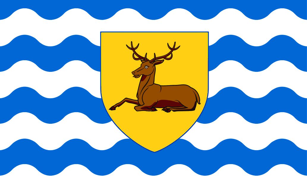
After the Romans left Britain, the Anglo-Saxons occupied the area which became Hertfordshire, creating their own towns, including the county town of Hertford. Hertfordshire is believed to have been part of the Kingdom of the East Saxons, but was taken into the Kingdom of the Mercians in the sixth century. Hertfordshire was founded as a county probably in the ninth or tenth centuries. The name Hertfordshire first appears in the Anglo-Saxon Chronicle in 1011. The Flag of Hertfordshire comprises a shield and stag from the arms of the Borough of Hertford on a background of blue and white wavy lines, which symbolise the county's many rivers.