
 Menu
MenuSearch the Gazetteer
Are the results not as expected? Modify your search term or change the scope to refine your search.
Results for a place that exactly matches ...
Glamorgan
Glamorgan, Wales
 Glamorgan (Morgannwg) is a maritime county in south Wales, containing the great cities of Cardiff and Swansea as well as many other large towns. Glamorgan was once called the "crucible of the Industrial Revolution," since it contained the world centres of three metallurgical industries and rich resources of coal. Glamorgan now has a diverse economic base including public administration, agriculture, manufacturing and the service sector. Glamorgan is a county of three contrasting localities. Across the north of the county run the Valleys, a densely populated, mountainous area with a proud industrial and mining heritage. Historically, this area was known as Blaenau Morganwg (the Glamorgan uplands). In the south is the Vale of Glamorgan, an undulating limestone plateau. Away from the major urban areas, the Vale mainly comprises farmland and small villages. The western part of Glamorgan comprises the ancient district of Gower including Swansea Bay and the Gower Peninsula.
Portrait of Glamorgan.
Place Type: Historic County
Alternative name(s): Morgannwg
Lat, Long: 51.612895,-3.56496
Grid Reference: SS917916
Country: Wales
GBPNID: 305781
Entry Type: Main listing (P)
URL: https://gazetteer.org.uk/place/Glamorgan,_305781
 Explore Glamorgan on Wikishire
The Rhymney River forms the entire border of Glamorgan with Monmouthshire. The largest settlements on the Glamorgan side are Pontlottyn, Hengoed, Ystrad Mynach, Llanbradach and, at its southern end, Caerphilly. Caerphilly Castle, built between 1268 and 1271, is the largest castle in Wales. The River Aber flows through the Aber Valley, with the former mining villages of Senghenydd and Abertridwr, before joining the Rhymney at Caerphilly. The Rhymney continues south through the eastern side of Cardiff to the Bristol Channel.

Caerphilly Castle
The Taff Bargoed Valley contains the villages of Bedlinog, Trelewis, Treharris and Nelson. It meets the Taff Valley at Quakers Yard. Parc Taf Bargoed is a former colliery site, now a haven for wildlife. Llancaiach Fawr is a Grade I Listed Tudor manor house.

Llancaiach Fawr
The River Taff forms from the confluence of the Taf Fechan and the Taf Fawr north of Merthyr Tydfil. Merthyr was one of the seats of the industrial revolution. Cyfarthfa Castle is a castellated mansion that was the home of the Crawshay family, ironmasters of Cyfarthfa Ironworks. The Taff meanders its way between Pentrebach and Abercanaid and through Troed-y-rhiw, Aberfan and Merthyr Vale to Quakers Yard. The Cynon and Taff Valleys meet at Abercynon where the Cynon flows into the Taff. The Rhondda and Taff Valleys meet at Pontypridd where the Rhondda River flows into the Taff. The Old Bridge is a 1756 stone bridge across the Taff. From Pontypridd, the Taff flows south through Hawthorn, Upper Boat, Gwaelod-y-Garth, Taff's Well and Radyr, before arriving at the village city of Llandaff. Llandaff Cathedral dates from the 12th century but there is evidence of Christian worship at the site since the 6th century. From Llandaff the Taff flows though Cardiff to the Severn Estuary.

The Old Bridge, Pontypridd
The River Cynon rises in Brecknockshire and flows into Glamorgan east of Hirwaun and then south to Aberdare. During the 19th century Aberdare became a thriving industrial settlement. The town was a major centre of the 1904–05 Religious Revival. From Aberdare the Cynon flows past the villages of Aberaman, Abercwmboi and Fernhill to the town of Mountain Ash before joining the Taff at Abercynon.
The Rhondda comprises two valleys – the Rhondda Fawr and the Rhondda Fach. Famous for its coal-mining heritage, the valleys produced a strong early Nonconformist Christian movement. The Rhondda is also famous for strong masculine cultural ties exemplified in its male voice choirs, sport and politics. Within the Rhodda Fach lie Maerdy, Blaenllechau, Ferndale, Tylorstown, Stanleytown, Ponygwaith, Wattstown and Ynyshir. Within the Rhondda Fawr lie Treherbert, Ynyswen, Treorchy, Pentre, Gelli, Ystrad, Llwynypia, Tonypandy, Penygraig and Williamstown. The rivers meet at Porth, which sees itself as the unofficial capital of the Rhondda. The River Rhondda then joins the Taff at Pontypridd.

Treorchy
The River Ely rises near the former mining village of Tonyrefail. Collenna House is a three-story mansion originally built in 1093, which overlooks the village. The river flows west of the Royal Mint in the north of Llantrisant, and past the Royal Glamorgan Hospital at Ynysmaerdy. After flowing through Talbot Green, the Ely is joined by the Afon Clun at Pontyclun. It then flows south into the Vale of Glamorgan and finally into the sea at Cardiff Bay.
The Ogmore Valley comprises Cwm Ogwr Fach with the village of Gilfach Goch and Cwm Ogwr Fawr with Nantymoel, Ogmore Vale and Lewistown. The two rivers form the Afon Ogwr at Blackmill, south of which the river flows on to Bridgend in the Vale.
The village of Blaengarw lies at the head of the Garw Valley, Pontycymer and Llangeinor lie further south. The River Garw then enters the Afon Ogwr.
The Llynfi Valley, formed by the River Llynfi, runs for around 10 miles from its source north of Maesteg to its confluence with the River Ogmore at Aberkenfig. The Llynfi has endured a long period of industrialisation and coal mining especially around Maesteg. There was an ironworks and brick works at Tondu.
In the Afan Valley, between the villages of Cymmer and Pontrhydyfen, lies the 48 square miles of the Afan Forest Park, well known for its mountain biking and hiking trails. South of Cwmavon, the River Afan enters the sea at Port Talbot.

Afan Forest Park
The Vale of Neath encompasses the upper reaches of the River Neath. Settlements include Pontneddfechan, Glynneath, Blaengwrach, Resolven, Tonna, Aberdulais, Cadoxton and Neath. The head of the Vale is known as Waterfall Country. Several spectacular falls lie on the border with Brecknockshire including Sgwd Gwladus and Sgws Einion Gam on the River Pyrddin, and the Sychryd Cascade on the River Sychryd. The Melincourt Falls were painted by Turner.

Sgwd Gwladus
In the Dulais Valley lie Seven Sisters, Crynant and Cilfrew. Aberdulais Falls are formed as the Dulais plunges over beds of hard Lower Pennant Sandstone just before it joins the River Neath.
The River Tawe rises in Brecknockshire and enters Glamorgan at Ystalfera. Others towns in the formerly industrialised Upper Swansea Valley include Pontardawe, Trebanos and Cyldach. The Lower Swansea Valley runs from south of Clydach down to Swansea Bay.
The City of Cardiff lies in the far south-east of the county, around the Rhymney, Taff and Ely rivers. Cardiff is the cultural centre of Wales and its capital. Cardiff has many landmark buildings including the Millennium Stadium, Pierhead Building, the Welsh National Museum and the Senedd. Cardiff Castle is a Norman Castle built on the footprint of a Roman fort, and reshaped to create a luxurious residence by the Marquess of Bute. Castell Coch is an elaborately decorated Victorian folly designed by William Burges for the Marquess of Bute. The castle stands on the footings of a mediæval castle. The National History Museum at St Fagans houses dozens of buildings from throughout Welsh history.

Cardiff Castle
Across the south of the county, from Cardiff to Porthcawl, stretches the Vale of Glamorgan, a lowland area mainly comprising farmland, small villages, and stunning coastline.
Penarth is a resort town with extensive Victorian and Edwardian architecture including its splendid 1895 pier. The nearby village of Dinas Powys takes its name from an Iron Age hill fort. It also has the remains of a Norman castle.

Penarth Pier
To the west of Penarth is Lavernock Point. The remains of the Lavernock Fort gun battery, first erected in 1860, are a listed Ancient Monument. A battery was also placed on the island of Flat Holm, three miles out in the Bristol Channel. The island has a history of occupation dating at least from the Anglo-Saxon and Viking periods. A sanatorium for Cholera patients was sited here from 1896 to 1935. The island is now a nature reserve. In 1897 Marconi transmitted and received the first wireless signals over open sea between Lavernock Point and Flat Holm.
From Lavernock Point the coast heads sharply west to the town of Barry. Barry grew from a village to a large town with its industrial docks. Barry Island is a famous resort with a fine beach and a peasure park. Passing the cliffs of Barry Island, the coastline becomes a low-lying promontory called the Lays, which continues west past the villages of Rhoose and Aberthaw before reaching Breaksea Point, the most southerly point of mainland Wales.
.jpg)
Barry Island
Beyond Breaksea Point is Limpert Bay, overlooked by the village of Gileston and the ancient encampment of Summerhouse Point. From here rise the spectacular cliffs of the Glamorgan Heritage Coast, which runs for 14 miles to Ogmore-on-Sea. The coast comprises rocky limestone cliffs, broad beaches and deeply fissured wave-cut platforms. Colhugh Beach is a popular surfing venue and has the remnants of an Iron Age fort and some of the finest examples of Jurassic Period fossils. Just to its north is the town of Llantwit Major where the 5th-century Saint Illtud founded a monastic community. The Roman villa at Caermead remains as faint earthworks.
Further west on the coast, there is an Iron Age promontory fort and a 19th-century lighthouse at Nash Point and an ancient cairn or cromlech at Cwm Marcross. The remains of Dunraven House, including its walled gardens, lie on the headland at Dunraven Bay. Both Southerndown and Ogmore-on-Sea have popular, west-facing beaches. Ogmore Castle is a Grade I listed ruin.

Southerndown beach
Away from the coast, the Vale of Glamorgan is quiet, rural and unspoilt. Cowbridge is one of very few mediæval walled towns in Wales. Old Beaupre Castle is a ruined mediæval fortified manor house near the village of St Hilary. New Beaupre is half a mile to the north. Dyffryn House is a manor house surrounded by a sumptuous garden.

Old Beaupre Castle
The town of Bridgend lies on the River Ogmore, crossed by The Old Bridge which gave the town its name. Newcastle Castle, built by Robert Fitzhamon in 1106, stands on Newcastle Hill. Coity Castle was built by Sir Payn "the Demon" de Turberville, one of the legendary Twelve Knights of Glamorgan. Ewenny Priory is the remains of 12th-century Benedictine monastry.
Across the River Ogmore from Ogmore-on-Sea lie the sand dunes of the Merthyr Mawr Warren. The ruins of Candleston Castle, a fortified 14th-century manor, lie on the edge of the dunes. The area is rich in archaeological sites including Tythegston Long Barrow and Mynydd Herbert Round Barrow. Merthyr Mawr pre-Norman Stones are a series of early mediæval stone pillars, slabs and crosses housed in St Teilo churchyard. Porthcawl is a seaside resort town with a harbour, a grand pavilion, an extensive promenade and seven beaches. North of the town, at the western extent of the Vale of Glamorgan, lie the Kenfig Burrows, an area of sand dunes managed as a nature reserve. The remains of Kenfig Castle lie here.

Porthcawl Promenade
North of Kenfig lies Port Talbot. Modern Port Talbot is a town formed from the merging of Baglan, Margam, and Aberafan. The name 'Port Talbot' first appears in 1837 as the name of the new docks built on the south-east side of the river Afan by the Talbot family. Margam Country Park estate was once owned by the Mansel Talbot family. Within the park are Margam Castle, a neo-Gothic country house that was the family seat, and the ruins of Margam Abbey, a Cistercian monastery. The Margam Stones are an important collections of Celtic stone crosses from the 6th to the 16th centuries.
.jpg)
Margam Stones museum
The River Afan commences the wide sweep of Swansea Bay, which from Port Talbot arcs around taking in Baglan Bay, Briton Ferry, Swansea and ending in Mumbles. The whole bay is shut in by high hills and is thickly encircled with sands. Within the bay are two of the major estuaries of Glamorgan: the River Neath at Port Talbot and the River Tawe, the central river of Swansea. Beyond the Tawe, the bay sweeps for six miles before reaching Mumbles Head. Mumbles Head is served by Mumbles Lighthouse, which sits on the further of two small islands off the head. Swansea Bay was immortalised in Bryan Martin Davies' Glas.
Swansea is the second largest city in Wales. During the 19th-century industrial heyday, Swansea was the key centre of the copper-smelting industry, earning the nickname Copperopolis. The ruins of Swansea Castle occupy a strategic position above the River Tawe. The Tabernacle Chapel at Morriston has been described as the "Nonconformist Cathedral of Wales". The poet Dylan Thomas was born at 5 Cwmdonkin Drive, Uplands, where he lived for 23 years and produced two-thirds of his published work from his tiny bedroom.

Morriston Tabernacle
Further west lies the Gower penisula, a place of renowned scenic beauty and sea air. Gower is known for its coastline, popular with walkers and outdoor enthusiasts, especially surfers. The southern coast consists of a series of small, rocky or sandy bays, such as Langland and Three Cliffs, and larger beaches such as Port Eynon, Rhossili and Oxwich Bay. The north of the peninsula has fewer beaches, and is home to the cockle-beds of Penclawdd. The interior is mainly farmland and common land. Gower has many caves, including Paviland Cave and Minchin Hole Cave. These are many historic sites on Gower including Bovehill Castle, Oystermouth Castle, Oxwich Castle, Pennard Castle, Penrice Castle and Weobley Castle. Worms Head is the long, thin headland marking the farthest end of Gower and of Glamorgan.

Worms Head
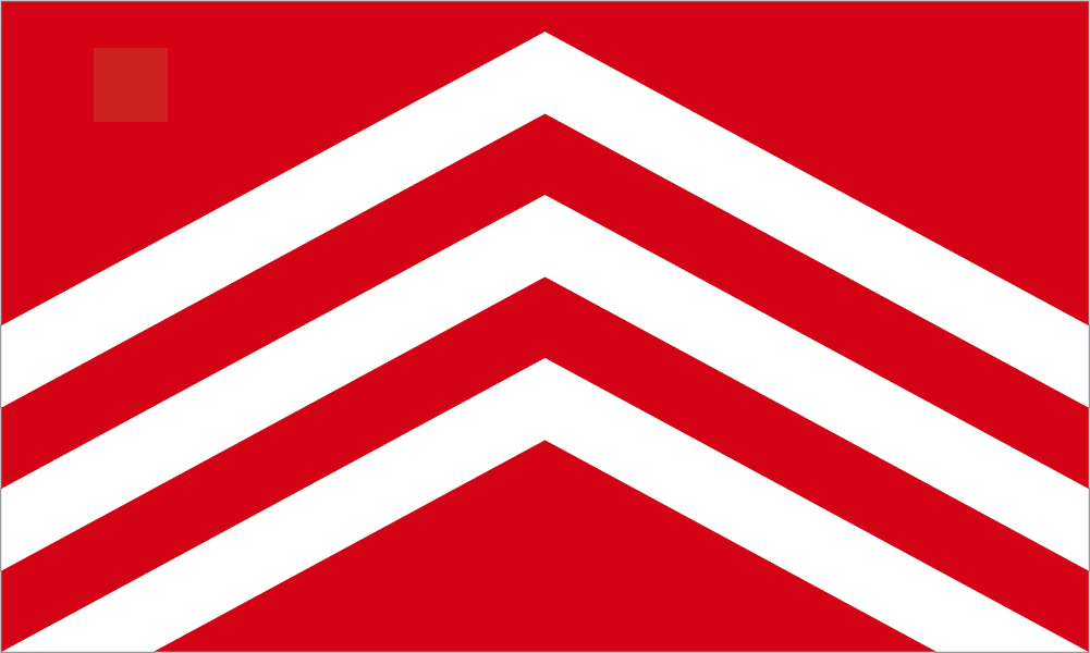
The region originated as an independent petty kingdom named Glywysing, believed to be named after a 5th-century Welsh king called Glywys. The name Morgannwg or Glamorgan ('territory of Morgan') reputedly derives from the 8th-century king Morgan ab Athrwys, otherwise known as "Morgan Mwynfawr" ('great in riches') who united Glywysing with the neighbouring kingdoms of Gwent and Ergyng. By virtue of its location and geography, Morgannwg was the second part of Wales, after Gwent, to fall under the control of the Normans and was frequently the scene of fighting between the Marcher Lords and Welsh princes. The Lordship of Glamorgan was established by the conquest of Glamorgan c. 1080 from its native Welsh ruler, Iestyn ap Gwrgant, by the Anglo-Norman nobleman Robert FitzHamon, feudal baron of Gloucester, and his legendary followers the Twelve Knights of Glamorgan. The Lordship of Glamorgan was one of the most powerful and wealthy of the Welsh Marcher Lordships. The seat was Cardiff Castle. The Laws in Wales Acts of 1535 established the County of Glamorgan through the amalgamation of the Lordship of Glamorgan with the lordships of Gower and Kilvey, creating Glamorgan as we know it today. The flag is a banner of the arms of Iestyn ap Gwrgant, the last ruler of the Kingdom of Morgannwg. The design of three silver chevrons on a red field features in the coats of arms of many of the councils in the area and on the flag of Cardiff where a dragon is holding the banner aloft symbolising Cardiff's status as county town of Glamorgan.

The Glamorgan Flag