
 Menu
MenuSearch the Gazetteer
Are the results not as expected? Modify your search term or change the scope to refine your search.
Results for a place that exactly matches ...
Essex
Essex, England
 Essex is a maritime county in the south-east of England. The south-western portion of the county lies within the metropolitan conurbation, and though the character remains of its individual towns such as Stratford, East Ham, Ilford, Dagenham, Barking, Leyton and Romford, nevertheless there are few spaces in between. Epping Forest, an ancient woodland covering 6,000 acres, and the market town of Waltham Abbey lie north-west of the metropolitan area. Along the Thames estuary is a string of industrial towns, including West Thurrock, Grays and Tilbury. Southend-on-Sea is a child of the great age of seaside holidays. North-east of the metropolitan area, Brentwood is a suburban town but still with a very rural feel; Billericay is a commuter town but ancient in origin; Basildon and Harlow were developed as new towns after the War. With the exception of the major towns of Colchester, Chelmsford and Braintree, the rest of the county is rural, with many small towns, villages and hamlets largely built in the traditional materials of timber and brick, with clay tile or thatched roofs. Chelmsford, the county town, sits at the centre of the shire. Colchester was for a time the capital of Roman Britain. The Essex coast is ragged, indented by river estuaries and full of tidal marshes. In contrast are the seaside resorts strung along the northern part of the county's coast: Clacton-on-Sea, Frinton-on-Sea, Walton-on-the-Naze and Dovercourt. Harwich is a major port. The north-west of Essex is rural, its only town being Saffron Walden, a jewel of Essex.
Place Type: Historic County
Lat, Long: 51.806757,0.436739
Grid Reference: TL680148
Country: England
GBPNID: 305766
Entry Type: Main listing (P)
URL: https://gazetteer.org.uk/place/Essex,_305766
 Explore Essex on Wikishire
The south-western portion of the county lies within the metropolitan conurbation, and though the character remains of its individual towns such as Stratford, East Ham, Ilford, Dagenham, Barking, Leyton and Romford, nevertheless there are few spaces in between. Eastbury Manor House (NT) is an Elizabethan house built on land that was formerly part of the demesne of Barking Abbey. Rainham Hall (NT) is a Georgian house in Rainham.

Eastbury Manor House, Barking
The metropolitan area is constrained in the west by Epping Forest, an ancient woodland covering 6,000 acres. Between the forest and the River Lee is the market town of Waltham Abbey, named from its former abbey, the last in England to be dissolved, now the Abbey Church of Waltham Holy Cross.
North-west of the metropolitan area, Brentwood has become a suburban town but still with a very rural feel. Billericay is also a commuter town but is ancient in origin. A meeting of the Pilgrim Fathers before they set sail in the Mayflower is said to have taken place in the town.
Basildon and Harlow were developed deliberately as new towns after the War, originally to resettle Londoners whose homes were lost in the Blitz, though they have since been much expanded.
.jpg)
The Gables, Old Harlow
Along the north shore of the Thames estuary is a string of towns given over to industry or leisure, as far as Shoeburyness, and among and to the north of them are new developments. Southend-on-Sea is a child of the great age of seaside holidays. Once it was no more than the south end of the village of Prittlewell, but when holidaymakers first came here in the Georgian period, the south end grew into a large and popular holiday resort.
To the north of the metropolitan area and the Thames estuary, with the exception of major towns such as Colchester, Chelmsford and Braintree, the county is rural, with many small towns, villages and hamlets largely built in the traditional materials of timber and brick, with clay tile or thatched roofs.
Chelmsford, the county town, sits at the centre of the shire. It was granted Letters Patent to become a city in 2012. The Shire Hall is a neo-classical, Georgian building with a Portland stone facade. Ingatestone Hall is a Grade I listed 16th-century manor house five miles south-west of Chelmsford. Braintree grew up on the Roman road known as Stane Street. Hedingham Castle, north of Braintree, is a Norman motte and bailey castle with a stone keep.
Colchester, in the north-east, claims to be the oldest town in Britain. It was for a time the capital of Roman Britain. Among its wealth of historic buildings is the Norman Colchester Castle, built on the foundations of a Roman temple. It became city in 2022.

Colchester Castle
The Essex coast is yet another aspect, where the land is flat and so carved by many rivers and tidal creeks that it is broken off with islands and vast flats where the only voices are the curlews. In stark contrast are the seaside resorts strong along the northern part of the county's coast: Clacton-on-Sea, Frinton-on-Sea, Walton-on-the-Naze and Dovercourt. Harwich, on the Stour estuary, is a major port.
The north-west of Essex is a rural area, its only town being Saffron Walden, a jewel of Essex. The town retains a rural appearance and many very old buildings dating from the Middle Ages and those from later ages, including its half-timbered Guildhall and the ruins of the 12th-century Walden Castle. Audley End House is an early 17th-century country house, with Capability Brown parklands. Thaxted has a mediæval guildhall and a 19th-century windmill. In this area, Essex rises with low chalk hills and winding valleys, the county's highest point (482 feet) being at High Wood on Chrishall Common.

Thaxted Guidhall
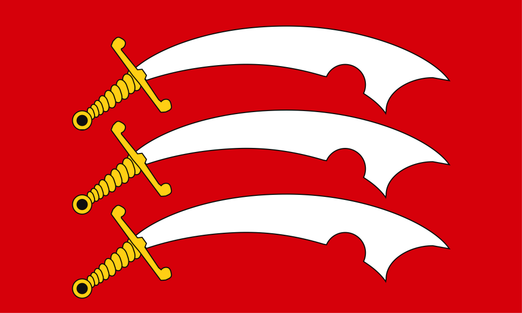
The name Essex derives from the Kingdom of the East Seaxe which was traditionally founded by Aescwine in AD 527, occupying territory to the north of the River Thames, incorporating Essex and what soon became Middlesex and Hertfordshire. The royal centre of this kingdom is thought to have been at Ithancestre (Bradwell-on-Sea). As the Mercians expanded in the seventh century, the territory of Essex was driven back to the lands east of the River Lea, which is the county's extent to this day. Essex Day is celebrated on October 26th, the feast day of St Cedd, bishop of the East Saxons and the county's patron saint. Cedd founded many churches, among them the Chapel of St Peter-on-the-Wall at Bradwell-on-Sea, one of the oldest intact Christian churches in England. The Essex flag is ancient in origin and features three notched Saxon seaxes on a red field.