
 Menu
MenuSearch the Gazetteer
Are the results not as expected? Modify your search term or change the scope to refine your search.
Results for a place that exactly matches ...
Dumfriesshire
Dumfriesshire, Scotland
Dumfriesshire is a maritime county which lies on the Solway Firth. Dumfriesshire's town and villages lie mainly in the great valleys running south into the Solway Firth: Eskdale, Annandale and Nithsdale. Each dale has its own character.
Place Type: Historic County
Lat, Long: 55.200215,-3.304763
Grid Reference: NY170903
Country: Scotland
GBPNID: 305791
Entry Type: Main listing (P)
URL: https://gazetteer.org.uk/place/Dumfriesshire,_305791
 Explore Dumfriesshire on Wikishire
Eskdale is the dale of River Esk and its tributaries. The White Esk rises in the Ettrick Hills at the north-eastern edge of the county, flowing down through the village of Eskdalemuir. This area is rich in archaeological remains, including two neolithic stone circles, the Loupin Stanes and the Girdle Stanes, and the bank barrow, Castle O'er.

The Loupin Stanes
South of Eskdalemuir, the White Esk meets the Black Esk to become the River Esk. Langholm, once a thriving centre for woollen milling trade, is the traditional seat of Clan Armstrong. The clan's most famous descendant, the astronaut Neil Armstrong, accepted in person being bestowed the first Freeman of the burgh in 1972.
The Esk then flows south through the village of Canonbie before meeting the Liddel at the border with Cumberland. The Esk heads south into Cumberland, before emptying into the Solway Firth after a few miles in England.
Annandale cuts through the middle of the county and forms much of the main route from Glasgow to the south. Judging by the towns, old inns and even Roman forts along its length it seems to have served this purpose for millennia.
The Annan rises near the Devil's Beef Tub, a remarkable chasm in the far north, near the spa town of Moffat. The town's heyday was in the Victorian era. The old well is still accessible.

The Old Well at Moffat
Historically the town of Lockerbie was a trading post for cattle and sheep. The town has grown based on its transport links with the motorway and the Carlisle-Glasgow railway line. In the garden of remembrance at Dryfesdale Cemetery is a memorial to the 270 victims of the Lockerbie bombing. There are memorials in Lockerbie and Moffat Roman Catholic churches. In Lockerbie Town Hall a stained-glass window depicts the flags of the 21 countries whose citizens lost their lives.
The town of Annan stands on the River Annan nearly two miles from its mouth on the Solway Firth. Annan Bridge, a stone bridge of three arches built between 1824 and 1827, was designed by Robert Stevenson.
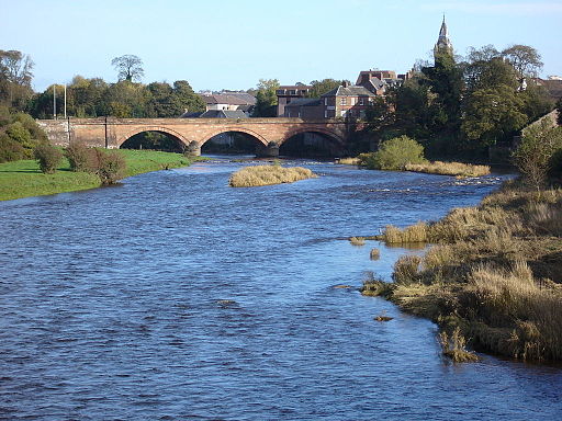
Annan Bridge
In the south-east corner of the county, close to where the River Sark forms the border with Cumberland, lies the town of Gretna. Near it is the world-famous village of Gretna Green. Gretna Green is a popular wedding destination due to its romantic wedding traditions dating back over centuries. These originated from cross-border elopements stemming from differences between Scottish and English marriage laws.
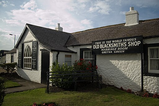
The old blacksmith's shop at Gretna Green
The Lochmaben Stone is a megalith standing a mile west of the Sark mouth. It was once possibly part of a stone circle. The Lochmaben Stone was a well-known 'marker' on the Scottish Marches and performed a number of functions such as arrangements for truces and exchange of prisoners.

The Lochmaben Stone
Nithdale is the valley of the River Nith which flows north to south through the western part of the county. In the north of the dale is the town of Sanqhuar. The ruins of Sanqhuar Castle stand nearby. Thornhill is a small town lying in the middle stretch of Nithsdale. Near the town stands Drumlanrig Castle, a 17th-century turreted mansion, once the ancient Douglas stronghold. Just north of the county town, Dumfries, the Nith becomes the border with Kirkcudbrightshire.

Drumlanrig Castle
Dumfries has not outgrown the charm which caused Robert Burns to choose it as his final home. Dumfries got its nickname 'Queen of the South' from local poet David Dunbar when standing in the 1857 general election. The heart of the town is found around Queensberry Square and High Street. Between the Devorgilla Bridge and the suspension bridge is a weir colloquially known as 'The Caul'. Near Dumfries is the Twelve Apostles, the largest stone circle on mainland Scotland.
A few miles south of Dumfries, the River Nith empties into the Solway Firth. Close by is Caerlaverock Castle, a moated triangular castle which was a stronghold of the Maxwell family from the 13th century until the 17th century. At Ruthwell, on the Solway Firth between Dumfries and Annan, is the Ruthwell Cross, the finest remaining example of an Anglo-Saxon standing cross.

The Ruthwell Cross
The many rivers and lochs of Dumfriesshire produce a most beautiful landscape, and are rich in fish, attracting trout and salmon fishing in season.
The British tribe which inhabited the area was called the Selgovae by the Romans. They have left many signs of their presence, such as hill forts and camp. There is much uncertainty about what happened in the centuries after the Romans withdrew, though the Selgovae were apparently pressured by the power of Strathclyde, by Scots from Ireland, and the Angles from Northumberland. Dumfriesshire was first created a sheriffdom around 1230. As a Border county Dumfriesshire was the scene of stirring deeds at various epochs, especially in the days of Robert Bruce. Edward I besieged Caerlaverock Castle, and the factions of Bruce, John Comyn and John Baliol were at constant feud. The Border clans were always at strife. These factions embroiled the dalesmen until the 18th century. The highlands of the shire afforded retreat to the persecuted Covenanters, who, at Sanquhar, published in 1680 their declaration against the king, anticipating the principles of the Glorious Revolution by several years. The Jacobite sentiment made little appeal to the people of Dumfriesshire.
Place Type: Historic County
Lat, Long: 55.200215,-3.304763
Grid Reference: NY170903
Country: Scotland
GBPNID: 305791
Entry Type: Main listing (P)
URL: https://gazetteer.org.uk/place/Dumfriesshire,_305791
Explore Dumfriesshire on WikishireEskdale is the dale of River Esk and its tributaries. The White Esk rises in the Ettrick Hills at the north-eastern edge of the county, flowing down through the village of Eskdalemuir. This area is rich in archaeological remains, including two neolithic stone circles, the Loupin Stanes and the Girdle Stanes, and the bank barrow, Castle O'er.

The Loupin Stanes
South of Eskdalemuir, the White Esk meets the Black Esk to become the River Esk. Langholm, once a thriving centre for woollen milling trade, is the traditional seat of Clan Armstrong. The clan's most famous descendant, the astronaut Neil Armstrong, accepted in person being bestowed the first Freeman of the burgh in 1972.
The Esk then flows south through the village of Canonbie before meeting the Liddel at the border with Cumberland. The Esk heads south into Cumberland, before emptying into the Solway Firth after a few miles in England.
Annandale cuts through the middle of the county and forms much of the main route from Glasgow to the south. Judging by the towns, old inns and even Roman forts along its length it seems to have served this purpose for millennia.
The Annan rises near the Devil's Beef Tub, a remarkable chasm in the far north, near the spa town of Moffat. The town's heyday was in the Victorian era. The old well is still accessible.

The Old Well at Moffat
Historically the town of Lockerbie was a trading post for cattle and sheep. The town has grown based on its transport links with the motorway and the Carlisle-Glasgow railway line. In the garden of remembrance at Dryfesdale Cemetery is a memorial to the 270 victims of the Lockerbie bombing. There are memorials in Lockerbie and Moffat Roman Catholic churches. In Lockerbie Town Hall a stained-glass window depicts the flags of the 21 countries whose citizens lost their lives.
The town of Annan stands on the River Annan nearly two miles from its mouth on the Solway Firth. Annan Bridge, a stone bridge of three arches built between 1824 and 1827, was designed by Robert Stevenson.

Annan Bridge
In the south-east corner of the county, close to where the River Sark forms the border with Cumberland, lies the town of Gretna. Near it is the world-famous village of Gretna Green. Gretna Green is a popular wedding destination due to its romantic wedding traditions dating back over centuries. These originated from cross-border elopements stemming from differences between Scottish and English marriage laws.

The old blacksmith's shop at Gretna Green
The Lochmaben Stone is a megalith standing a mile west of the Sark mouth. It was once possibly part of a stone circle. The Lochmaben Stone was a well-known 'marker' on the Scottish Marches and performed a number of functions such as arrangements for truces and exchange of prisoners.

The Lochmaben Stone
Nithdale is the valley of the River Nith which flows north to south through the western part of the county. In the north of the dale is the town of Sanqhuar. The ruins of Sanqhuar Castle stand nearby. Thornhill is a small town lying in the middle stretch of Nithsdale. Near the town stands Drumlanrig Castle, a 17th-century turreted mansion, once the ancient Douglas stronghold. Just north of the county town, Dumfries, the Nith becomes the border with Kirkcudbrightshire.

Drumlanrig Castle
Dumfries has not outgrown the charm which caused Robert Burns to choose it as his final home. Dumfries got its nickname 'Queen of the South' from local poet David Dunbar when standing in the 1857 general election. The heart of the town is found around Queensberry Square and High Street. Between the Devorgilla Bridge and the suspension bridge is a weir colloquially known as 'The Caul'. Near Dumfries is the Twelve Apostles, the largest stone circle on mainland Scotland.
A few miles south of Dumfries, the River Nith empties into the Solway Firth. Close by is Caerlaverock Castle, a moated triangular castle which was a stronghold of the Maxwell family from the 13th century until the 17th century. At Ruthwell, on the Solway Firth between Dumfries and Annan, is the Ruthwell Cross, the finest remaining example of an Anglo-Saxon standing cross.

The Ruthwell Cross
The many rivers and lochs of Dumfriesshire produce a most beautiful landscape, and are rich in fish, attracting trout and salmon fishing in season.
The British tribe which inhabited the area was called the Selgovae by the Romans. They have left many signs of their presence, such as hill forts and camp. There is much uncertainty about what happened in the centuries after the Romans withdrew, though the Selgovae were apparently pressured by the power of Strathclyde, by Scots from Ireland, and the Angles from Northumberland. Dumfriesshire was first created a sheriffdom around 1230. As a Border county Dumfriesshire was the scene of stirring deeds at various epochs, especially in the days of Robert Bruce. Edward I besieged Caerlaverock Castle, and the factions of Bruce, John Comyn and John Baliol were at constant feud. The Border clans were always at strife. These factions embroiled the dalesmen until the 18th century. The highlands of the shire afforded retreat to the persecuted Covenanters, who, at Sanquhar, published in 1680 their declaration against the king, anticipating the principles of the Glorious Revolution by several years. The Jacobite sentiment made little appeal to the people of Dumfriesshire.