
 Menu
MenuSearch the Gazetteer
Are the results not as expected? Modify your search term or change the scope to refine your search.
Results for a place that exactly matches ...
Carmarthenshire
Carmarthenshire, Wales
Carmarthenshire (Sir Gaerfyrddin or, informally, Sir Gâr) is a maritime county in the south-west of Wales. With its fertile land and agricultural produce, Carmarthenshire is known as the "Garden of Wales". The coast of Carmarthenshire curves around Carmarthen Bay, the quiet dip of the fields running into broad sandy beaches. The southern part of the county is generally low lying and pastoral. The north and east are mountainous. The county town, Carmarthen, is possibly the oldest town in Wales - the Roman fort dates from around AD 75. Llanelli, the largest town, sits on the Lougher estuary. Laugharne, on the estuary of the River Tâf, is famous for its association with Dylan Thomas.
Portrait of Carmarthenshire.
Place Type: Historic County
Alternative name(s): Sir Gaerfyrddin, Sir Gâr
Lat, Long: 51.929112,-4.11895
Grid Reference: SN544277
Country: Wales
GBPNID: 305779
Entry Type: Main listing (P)
URL: https://gazetteer.org.uk/place/Carmarthenshire,_305779
 Explore Carmarthenshire on Wikishire
The valley of the River Tywi runs from the north-east of the county across the whole county to Carmarthen Bay south of Carmarthen. The River Tywi rises in Cardiganshire and enters Carmarthenshire in the county's far north-east. It flows south-west to Llandovery. The Roman fort at Llanfair Hill was known to the Romans as Alabum. Llandovery Castle was built in 1110, changing hands between the Normans and Welsh several times until the reign of King Edward I.
The Tywi broadens south of Llandovery, continuing on its south-west course to Llandeilo where it is crossed by a 19th-century stone bridge. Dinefwr Castle is a spectacular castle overlooking the River Tywi near the town. The ruins of Carreg Cennen Castle lie in the nearby village of Trap, occupying a spectacular location above a limestone precipice. North of the town, Talley Abbey is a ruined former monastery of the Premonstratensians. The National Botanic Garden of Wales is laid out at Llanarthney. The garden is both a visitor attraction and a centre for botanical research.

Carreg Cennen Castle
The Tywi continues west to the county town, Carmarthen, possibly the oldest town in Wales. When Britannia was a Roman province, Carmarthen was the civitas capital of the Demetae tribe and known as Moridunum. The Roman fort here is believed to date from AD 75-77. Near the fort is one of seven surviving Roman amphitheatres in the UK. Carmarthen Castle was first built by Walter, Sheriff of Gloucester in the early 1100s, the castle was captured and destroyed on several occasions before being rebuilt in stone during the 1190s. South of Carmarthen, the Tywi opens into the middle of a three-branched estuary, with the Gwendraeth and the Taf, into Carmarthen Bay.
East of the Tywi valley, the Black Mountain range extends into Carmarthenshire from Brecknockshire. The county top is the north-west Fan Foel summit on the Fan Brycheiniog mountain.

Fan Foel from Picws Du
The south-east part of Carmarthenshire is generally low lying and pastoral. Ammanford is a former coal-mining town close to the Glamorgan border. Llanelli, the largest town in Carmarthenshire, sits on the Loughor estuary on the southernmost coast. It was a market town that became the global centre for tinplate production in the 19th century. The economy is now based on leisure and tourism.
Burry Port, on the Loughour estuary, started as Pembrey New Harbour in 1836. The harbour is now a marina for small leisure craft. Kidwelly stands on the River Gwendraeth above Carmarthen Bay. The present remains of Kidwelly Castle include work from about 1111 to about 1476. Cefn Sidan is a long, sandy beach popular for holidaymakers and visually stunning. The beach and its dunes form the outer edge of the Pembrey Burrows between Burry Port and Kidwelly.

Burry Port harbour and lighthouse
The Cambrian mountains extend into the north of the county. The Brechfa Forest covers 16,000 acres, a large part of the ancient Glyn Cothi Forest. In the 1900s Brechfa Forest was replanted with conifers to boost Britain’s timber reserve. Brechfa Forest now provides open access space for walkers, horse riders and cyclists.
In the north-west of the county lies Newcastle Emlyn, a little town with a ruined castle, tucked into a pair of meanders in the River Teifi, which here forms the border with Cardiganshire.
The south-west the county is mainly rolling grassland consisting of moderate sized fields. The main agricultural enterprise is dairy farming. The soils grow good crops of potatoes, cereals and fruits. The town of St Clears lies in the centre of this. South of St Clears, on the Tâf estuary, lies Laugharne, known for having been the home of Dylan Thomas from 1949 until his death in 1953. Laugharne is thought to have been an inspiration for the fictional town of Llareggub in Under Milk Wood. Laugharne contains many fine examples of Georgian townhouses with several earlier vernacular cottages. The ruins of the Laugharne Castle are the result of much development as the building graduated from an earthwork castle to a Tudor mansion. Llansteffan Castle is a Norman castle overlooking the River Towy as it enters Carmarthen Bay near the village of Llansteffan.
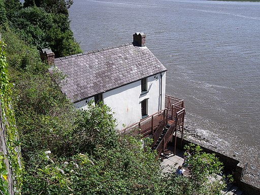
The Dylan Thomas Boathouse, Laugharne
Pendine Sands is seven miles of beach on the shores of Carmarthen Bay. It stretches west to east from Gilman Point to Laugharne Sands. The village of Pendine is close to the western end of Pendine Sands. In the early 1900s the sands were used as a venue for car and motor cycle races. Malcolm Campbell and J. G. Parry-Thomas set the world land-speed record here five times between 1924 and 1927.

Pendine Sands
Whitland is a small town close to the Pembrokeshire border. Here in 930 met an assembly of lawyers and churchmen, sometimes described as the first Welsh parliament, called by King Hywel Dda to codify the Welsh laws. The mediæval Cistercian abbey pre-dates Tintern but now is very much a ruin.
Carmarthenshire was constituted as a county by the Statute of Rhuddlan 1284, following Edward I's conquest of Wales. The area had been part of the Kingdom of Deheubarth during the High Middle Ages. The area had then been much disputed between the Normans and the Welsh lords. Owain Glyndŵr captured Carmarthen Castle in 1405. However, when his support dwindled, the principal men of the county returned their allegiance to King Henry V. Parliamentary forces under Colonel Roland Laugharne captured Carmarthen Castle during the Civil War, but then later joined the Royalists. Carmarthen Castle was recaptured by the Parliamentarians in 1648, after which Cromwell ordered it to be slighted. The first industrial canal in Wales was built in 1768 to convey coal from the Gwendraeth Valley to the coast. The county prospered during the Napoleonic Wars with the increased demand for coal, iron and agricultural goods. The landscape changed as much woodland was cleared to make way for more food production, and mills, power stations, mines and factories were developed between Llanelli and Pembrey. Carmarthenshire was at the centre of the Rebecca Riots around 1840, when local farmers and agricultural workers dressed as women and rebelled against higher taxes and tolls.
Portrait of Carmarthenshire.
Place Type: Historic County
Alternative name(s): Sir Gaerfyrddin, Sir Gâr
Lat, Long: 51.929112,-4.11895
Grid Reference: SN544277
Country: Wales
GBPNID: 305779
Entry Type: Main listing (P)
URL: https://gazetteer.org.uk/place/Carmarthenshire,_305779
Explore Carmarthenshire on WikishireThe valley of the River Tywi runs from the north-east of the county across the whole county to Carmarthen Bay south of Carmarthen. The River Tywi rises in Cardiganshire and enters Carmarthenshire in the county's far north-east. It flows south-west to Llandovery. The Roman fort at Llanfair Hill was known to the Romans as Alabum. Llandovery Castle was built in 1110, changing hands between the Normans and Welsh several times until the reign of King Edward I.
The Tywi broadens south of Llandovery, continuing on its south-west course to Llandeilo where it is crossed by a 19th-century stone bridge. Dinefwr Castle is a spectacular castle overlooking the River Tywi near the town. The ruins of Carreg Cennen Castle lie in the nearby village of Trap, occupying a spectacular location above a limestone precipice. North of the town, Talley Abbey is a ruined former monastery of the Premonstratensians. The National Botanic Garden of Wales is laid out at Llanarthney. The garden is both a visitor attraction and a centre for botanical research.

Carreg Cennen Castle
The Tywi continues west to the county town, Carmarthen, possibly the oldest town in Wales. When Britannia was a Roman province, Carmarthen was the civitas capital of the Demetae tribe and known as Moridunum. The Roman fort here is believed to date from AD 75-77. Near the fort is one of seven surviving Roman amphitheatres in the UK. Carmarthen Castle was first built by Walter, Sheriff of Gloucester in the early 1100s, the castle was captured and destroyed on several occasions before being rebuilt in stone during the 1190s. South of Carmarthen, the Tywi opens into the middle of a three-branched estuary, with the Gwendraeth and the Taf, into Carmarthen Bay.
East of the Tywi valley, the Black Mountain range extends into Carmarthenshire from Brecknockshire. The county top is the north-west Fan Foel summit on the Fan Brycheiniog mountain.

Fan Foel from Picws Du
The south-east part of Carmarthenshire is generally low lying and pastoral. Ammanford is a former coal-mining town close to the Glamorgan border. Llanelli, the largest town in Carmarthenshire, sits on the Loughor estuary on the southernmost coast. It was a market town that became the global centre for tinplate production in the 19th century. The economy is now based on leisure and tourism.
Burry Port, on the Loughour estuary, started as Pembrey New Harbour in 1836. The harbour is now a marina for small leisure craft. Kidwelly stands on the River Gwendraeth above Carmarthen Bay. The present remains of Kidwelly Castle include work from about 1111 to about 1476. Cefn Sidan is a long, sandy beach popular for holidaymakers and visually stunning. The beach and its dunes form the outer edge of the Pembrey Burrows between Burry Port and Kidwelly.

Burry Port harbour and lighthouse
The Cambrian mountains extend into the north of the county. The Brechfa Forest covers 16,000 acres, a large part of the ancient Glyn Cothi Forest. In the 1900s Brechfa Forest was replanted with conifers to boost Britain’s timber reserve. Brechfa Forest now provides open access space for walkers, horse riders and cyclists.
In the north-west of the county lies Newcastle Emlyn, a little town with a ruined castle, tucked into a pair of meanders in the River Teifi, which here forms the border with Cardiganshire.
The south-west the county is mainly rolling grassland consisting of moderate sized fields. The main agricultural enterprise is dairy farming. The soils grow good crops of potatoes, cereals and fruits. The town of St Clears lies in the centre of this. South of St Clears, on the Tâf estuary, lies Laugharne, known for having been the home of Dylan Thomas from 1949 until his death in 1953. Laugharne is thought to have been an inspiration for the fictional town of Llareggub in Under Milk Wood. Laugharne contains many fine examples of Georgian townhouses with several earlier vernacular cottages. The ruins of the Laugharne Castle are the result of much development as the building graduated from an earthwork castle to a Tudor mansion. Llansteffan Castle is a Norman castle overlooking the River Towy as it enters Carmarthen Bay near the village of Llansteffan.
.jpg)
The Dylan Thomas Boathouse, Laugharne
Pendine Sands is seven miles of beach on the shores of Carmarthen Bay. It stretches west to east from Gilman Point to Laugharne Sands. The village of Pendine is close to the western end of Pendine Sands. In the early 1900s the sands were used as a venue for car and motor cycle races. Malcolm Campbell and J. G. Parry-Thomas set the world land-speed record here five times between 1924 and 1927.
.jpg)
Pendine Sands
Whitland is a small town close to the Pembrokeshire border. Here in 930 met an assembly of lawyers and churchmen, sometimes described as the first Welsh parliament, called by King Hywel Dda to codify the Welsh laws. The mediæval Cistercian abbey pre-dates Tintern but now is very much a ruin.
Carmarthenshire was constituted as a county by the Statute of Rhuddlan 1284, following Edward I's conquest of Wales. The area had been part of the Kingdom of Deheubarth during the High Middle Ages. The area had then been much disputed between the Normans and the Welsh lords. Owain Glyndŵr captured Carmarthen Castle in 1405. However, when his support dwindled, the principal men of the county returned their allegiance to King Henry V. Parliamentary forces under Colonel Roland Laugharne captured Carmarthen Castle during the Civil War, but then later joined the Royalists. Carmarthen Castle was recaptured by the Parliamentarians in 1648, after which Cromwell ordered it to be slighted. The first industrial canal in Wales was built in 1768 to convey coal from the Gwendraeth Valley to the coast. The county prospered during the Napoleonic Wars with the increased demand for coal, iron and agricultural goods. The landscape changed as much woodland was cleared to make way for more food production, and mills, power stations, mines and factories were developed between Llanelli and Pembrey. Carmarthenshire was at the centre of the Rebecca Riots around 1840, when local farmers and agricultural workers dressed as women and rebelled against higher taxes and tolls.