
 Menu
MenuSearch the Gazetteer
Are the results not as expected? Modify your search term or change the scope to refine your search.
Results for a place that exactly matches ...
Cardiganshire
Cardiganshire, Wales
 Cardiganshire is a maritime county in west Wales, bounded on the west by Cardigan Bay. The coast is a gentle one, alternating pleasant, sandy beaches and seacliffs. Along it lie the resorts towns of Aberporth, Aberaeron, Borth and New Quay and the university town of Aberystwyth. Away from the coast, Cardiganshire is a pastoral county of scattered farms and small agricultural villages. The county rises into gentle farming country, rising up to the dramatic west slopes of the Cambrian Mountains. The chief river is the Teifi along which lie the university town of Lampeter and the county town of Cardigan. Tourism and agriculture are the most important industries.
 Portrait of Cardiganshire
Place Type: Historic County
Alternative name(s): Sir Aberteifi, Ceredigion
Lat, Long: 52.21917,-4.036011
Grid Reference: SN610598
Country: Wales
GBPNID: 305778
Entry Type: Main listing (P)
URL: https://gazetteer.org.uk/place/Cardiganshire,_305778
 Explore Cardiganshire on Wikishire
Cardiganshire curves along the coast of Cardigan Bay, a coast marked by fine, sandy beaches and rugged cliffs. Cardiganshire's coast boasts some of the whitest beaches and clearest, turquoise seas in the United Kingdom. Off Cardiganshire is the only permanent summer residence of bottle-nosed dolphins in the United Kingdom.
The coast starts, at its southern end, at the mouth of the River Teifi. Just inland, on the Teifi, is the county town of Cardigan. Cardigan was an important seaport until the Teifi silted up. Cardigan Castle was built by Robert Montgomery in 1093 after the Norman army had conquered Ceredigion. In 1176 the Castle became the site of the first competitive Eisteddfod.
The small seaside town of Aberporth overlooks two sandy beaches and is one of Cardiganshire’s favourite holiday destinations. Bottlenose dolphins are seen frequently close to shore. Further north, New Quay has a picturesque harbour and expansive sandy beaches. There is still significant employment in sea fishing and fish processing.

Aberporth
Aberaeron is a resort town at the mouth of the River Aeron. It was planned and developed from 1805 by the Rev Alban Thomas Jones Gwynne, as a port and shipbuilding town. Nearby is Llanerchaeron, a Grade I listed mansion, designed and built in 1795 by John Nash as a model, self-sufficient farm complex.

Llanerchaeron
Aberystwyth is a historic market town and holiday resort. It stands where the rivers Ystwyth and Rheidol meet on Cardigan Bay. Aberystwyth had been a major Welsh educational centre since the establishment of a university college in 1872. Aberystwyth has a pier and a fine seafront which stretches from Constitution Hill at the north end of the Promenade to the mouth of the harbour at the south. Constitution Hill is scaled by the Aberystwyth Electric Cliff Railway giving access to fine views and attractions at the top. Aberystwyth Castle was built by King Edward I during the First Welsh War in the late 13th century. At the end of the civil war, Parliament ordered that the castle be slighted, resulting it its current ruinous state.

Constitution Hill, Aberystwyth
Borth is a small holiday seaside resort a few miles north of Abersytwyth. North of it lies the mouth of the Dyfi, across which lies Merionethshire.
Inland the county rises into gentle farming country and river valleys, rising up to the dramatic west slopes of the Cambrian Mountains. The highest point is Plynlimon at which three rivers have their source: the Severn, the Wye, and Rheidol, the last of which meets the Mynach in a 300-foot plunge at the Devil's Bridge chasm. The Vale of Rheidol Railway is a narrow-gauge heritage railway running between Aberystwyth and Devil's Bridge.
The county's main river is the Teifi, which has its source in Llyn Teifi in the mountains of the east. The river flows south past the scenic ruins of Strata Florida Abbey, a former Cistercian abbey founded in 1164. At Strata Florida the most important primary historical source for early Welsh history, the Brut y Tywysogion, is believed to have been compiled. The river then passes through the vast Cors Caron (Tregaron Bog) raised bog, the most intact surviving raised bog landscape in the UK. The market town of Tregaron lies at the south end of the bog on the River Brenig, a tributory of the Teifi.

Strata Florida Abbey
Over the next 30 miles, the Teifi meanders south-west in a gentle arc reaching the county border near Cwmann. From here the river is the border, first with Carmarthenshire and then with Pembrokeshire, all the way to the sea. The university town of Lampeter lies where the River Teifi and the Afon Dulas meet. The University of Wales, Trinity Saint David campus adds substantially to the resident population giving the rural town a cosmopolitan feel.
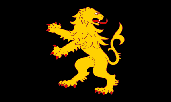
The name of the county comes from the ancient Kingdom of Ceredigion, which means Land of Ceredig, who was a son of Cunedda, a chieftain who re-conquered much of western Britain from the Irish in the 5th century. It remained a kingdom ruled by Ceredig's descendants until it expanded and changed its name, first to Seisyllwg in the late 7th century and, after the union of Seisyllwg with Dyfed, it was incorporated into Deheubarth in the mid 10th century. In 1282, Edward I of England conquered the principality of Wales and divided the area into counties. The name Cardigan is an Anglicisation of the name for the historic kingdom of Ceredigion. Cardiganshire has long been associated with a reguardant lion (looking backwards). This design was attributed as the arms of the ancient Welsh ruler Gwaithfoed and his kingdom of Ceredigion. The arms form the basis of the Cardiganshire flag.

Cardiganshire flag in Aberaeron
The county is traditionally strongly Welsh-speaking. At the time of the 2011 Census 47% of the population could speak Welsh, though the proportion is far higher away from the coast and the two university towns. Despite the strength of the Welsh language, the people of the county are known as 'Cardis' from the county's English name.