Search the Gazetteer
Are the results not as expected? Modify your search term or change the scope to refine your search.
Results for a place that exactly matches ...
Caithness
Caithness, Scotland
 Caithness is a maritime county which lies in the very north-eastern corner of Great Britain, bounded only by Sutherland and the sea. Caithness is a land of open, rolling farmland, moorland and scattered settlements. The county is fringed to the north and east by dramatic coastal scenery and is home to large, internationally-important colonies of seabirds. The surrounding waters of the Pentland Firth and the North Sea hold a great diversity of marine life. Away from the coast, the landscape is dominated by open moorland and blanket bog known as the Flow Country which is the largest expanse of blanket bog in Europe, extending into Sutherland. This is divided up along the straths (river valleys) by more fertile farm and croft land.
Place Type: Historic County
Lat, Long: 58.442629,-3.521997
Grid Reference: ND112514
Country: Scotland
GBPNID: 305788
Entry Type: Main listing (P)
URL: https://gazetteer.org.uk/place/Caithness,_305788
 Explore Caithness on Wikishire
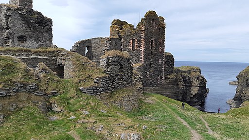
Wick, the county town, stands on the east coast. Wick Bay provides a capacious harbour, space for the grand buildings of the town and for its practical functions as a small port. The ruined Castle of Old Wick lies on the coast south of the town. Built in the 12th century when the Norse earldom of Orkney included Caithness, it is thought to have been the Earl of Orkney's stronghold on the mainland. The ruins of the 15th-century Castle Sinclair Girnigoe stand on the coast three miles north of Wick.

Castle Sinclair Girnigoe
Thurso, on the north coast, was an important Norse port. Thurso has a fine harbour and beach and looks out over the Pentland Firth to the Orkney island of Hoy and the famous towering Old Man of Hoy. Thurso's port, Scrabster, is the main commercial and passenger port connecting Orkney to Great Britain.
The village of John o' Groats is famed as the north-eastern extremity of Great Britain, although Duncansby Head, to its east, is actually the most north-easterly point. The Duncansby Head Lighthouse was built in 1924. Six miles west of John O' Groats lies the Castle of Mey, former holiday home of Queen Elizabeth, the Queen Mother. Dunnet Head, 11 miles west of John O' Groats, is the most northerly point in Great Britain.

Duncansby Head
The county's wildlife includes the commonplace and the exotic, providing a safe home for beasts and birds once common but now become rare elsewhere. Amongst these are waders, water voles and flocks of over-wintering birds. Many rare mammals, birds and fish have been sighted or caught in and around Caithness waters. Harbour porpoises, Risso's dolphins, bottle-nosed dolphins, common dolphins, Atlantic white-sided dolphins, white-beaked dolphins, minke whales and long-finned pilot whales swim in its waters. Both grey seals and common seals come close to the shore to feed, rest and raise their pups, and otters can be seen close to river mouths.
The Caithness landscape is rich with the remains of pre-historic occupation. These include the Grey Cairns of Camster, the Stone Lud, the Hill O Many Stanes, a complex of sites around Loch Yarrows and over 100 brochs.

Hill O Many Stanes
Isolated as it is, the county's historical heritage connects it as much with Orkney and the Norse as with Scotland. It is believed that when the Norsemen arrived, probably in the 10th century, the county was Pictish. Many of the place names of Caithness are Norse in origin. The Norse left numerous coastal castles, now mostly in ruins. Norway recognised Caithness as Scottish at the Treaty of Perth in 1266.


 Menu
Menu