
 Menu
MenuSearch the Gazetteer
Are the results not as expected? Modify your search term or change the scope to refine your search.
Results for a place that exactly matches ...
Buckinghamshire
Buckinghamshire, England
 Buckinghamshire is an inland county in the south of England. The Thames forms Buckinghamshire's southern border. On its banks are several pretty riverside villages, amongst them Datchet, Eton and Taplow. Slough and its suburbs form a major urban area in the south-east of the county. North of Slough lie Burnham Beeches, a 900-acre semi-ancient beech forest. Gerrards Cross and Beaconsfield lie north of the beeches. North of these, the delightful Chiltern Hills sweep north-westward across the county, with beech woods in the west, rising to higher, more windswept landscape around Ivinghoe Beacon, and all full of pretty villages of flint and thatch. The market towns of Amersham and High Wycombe lie amongst the Chiltern Hills. The Vale of Aylesbury is a large area of flat land in the midst of Buckinghamshire, drained by the River Thame and its tributaries. Aylesbury has been a major market town since Anglo-Saxon times. Buckingham is a bustling small market town. In the north-east of the county lies Milton Keynes, developed as a new town from the 1960s. Bletchley is known for Bletchley Park, the headquarters of Britain's Second World War codebreaking organisation. The market town of Olney, in the far north-east, is famous for the Olney Pancake Race which dates to 1455.
Place Type: Historic County
Lat, Long: 51.843136,-0.836573
Grid Reference: SP802166
Country: England
GBPNID: 305816
Entry Type: Main listing (P)
URL: https://gazetteer.org.uk/place/Buckinghamshire,_305816
 Explore Buckinghamshire on Wikishire
The Thames forms Buckinghamshire's southern border with Surrey and Berkshire. On its banks are several pretty riverside villages, amongst them Datchet, Eton (home to the famous school) and Taplow. Cliveden (NT) is an Italianate mansion set on the banks of the River Thames at Taplow. As home of Nancy Astor, the house was the meeting place of the Cliveden set of the 1930s. The prosperous town of Marlow lies further upstream. Marlow Rowing Club, founded in 1871, is one of Britain's premier rowing clubs.

Cliveden
The town of Slough and its suburbs form a major urban area in the south-east of the county. Once a small village, the establishment of the Slough Trading Estate in the 1920s led to spectacular growth. Many of the original villages of the area are now urban districts of Slough. The villages of Chalvey, Langley and Upton have become suburbs. North of Slough lie Burnham Beeches, a 900-acre semi-ancient beech forest, much used a location by the film industry.
The town of Gerrards Cross and the nearby village of Chalfont St Peter lie close to the Hertfordshire border. Bulstrode is an English country house and its large park. The estate spreads across Chalfont St Peter and Gerrard's Cross and predates the Norman conquest.
Beaconsfield is a prosperous market town with two centres; the historic heart on the old London road and the New Town built around the railway station.
To the north of Beaconsfield and Gerrard's Cross, the delightful Chiltern Hills sweep north-westward across the county. They give the shire much of its character; with beech woods in the west, rising to higher, more windswept landscape around Ivinghoe Beacon, and all full of pretty villages of flint and thatch. It provides fine walking country.
Ivinghoe Beacon
The market town of High Wycombe lies in the valley of the River Wye surrounded by the Chiltern Hills. Hughenden Manor (NT), a red brick Victorian mansion near the town, was the country house of Benjamin Disraeli. West Wycombe Park (NT) is a grand country house near West Wycombe, conceived as a pleasure palace for the 18th-century libertine and dilettante Sir Francis Dashwood.
The market towns of Amersham and Chesham lies amongst the Chiltern Hills. Amersham's broad High Street is lined with Georgian buildings and the Market Hall, built in 1682. The Chilterns village of Bradenham is renowned for its beauty in a beautiful setting, and to preserve it the whole village has been owned by the National Trust since 1956. Halton House is a country house built for Alfred Freiherr de Rothschild between 1880 and 1883. It is used as the officers' mess for RAF Halton.

The Market Hall, Amersham
The boundary of the Chiltern Hills is clearly defined on the north-west side by the scarp slope. The small market town of Wendover sits in a gap in this scarp. The Wendover Woods roll over the countryside. Haddington Hill (876 feet) is Buckinghamshire's county top.
Princes Risborough sits sheltered beneath the scarp slope of the Chilterns. Princes Risborough Manor House (NT) is an elegant 17th-century house. The town is overlooked by the Whiteleaf Cross, carved in the chalk of the hillside. North from here the land flattens out into the Vale of Aylesbury.
The Vale of Aylesbury is a large area of flat land in the midst of Buckinghamshire. The Vale is drained by the River Thame and its tributaries. The Vale has fine agricultural land.
The county town of Aylesbury had been a major market town since Anglo-Saxon times. The Buckinghamshire County Museum is housed in Ceely House. The Aylesbury Duck is a local speciality. The pioneering rehabilitation work carried by Sir Ludwig Guttmann at Stoke Mandeville Hospital led to the development of the Paralympic Games. Outside the town are Chequers, the Prime Minister's country residence; the 17th-century Hartwell House (NT); and Waddesdon Manor (NT), a grand country house built in the Neo-Renaissance style of a French château for Baron Ferdinand de Rothschild.
Winslow is a small market town in the Vale, 30 miles north-west of Aylesbury. Winslow Hall was built possibly from the designs of Sir Christopher Wren by William Lowndes, secretary to the Treasury. His name and the date 1700 can be seen over the door. Nearby is Claydon House (NT), a 18th-century country house.
Buckingham, in the north-west of the Vale, is a bustling small market town. Its heart is its historic market place. Buckingham Chantry Chapel (NT) is a 15th-century chapel. Nearby Stowe House is a grand country house which is now school. Stowe Landscape Gardens (NT) are a significant example of the English garden style.
.jpg)
Stowe Landscape Gardens
Brill Windmill, in the west of the Vale, is one of the most ancient post mills in the country. In the nearby village of Boarstall are Boarstall Tower, a 14th-century moated gatehouse, and the 17th century Boarstall Duck Decoy (NT), one of the few working decoys in Britain.
The small town of Linslade lies on west bank of the River Ouzel, the border with Bedfordshire. Across the border is Leighton Buzzard. South of the town, Mentmore Towers has been described as one of the greatest houses of the Victorian era.
In the north-east of the county lies Milton Keynes, developed as a new town from the 1960s. Its area incorporated three existing towns, fifteen villages and the farmland in between. The villages have become districts within the town. The three towns have maintained a distinct identity. Bletchley is best known for Bletchley Park, the headquarters of Britain's Second World War codebreaking organisation, now a museum. Stony Stratford stands on Watling Street where the Great Ouse divides Buckinghamshire from Northamptonshire. Wolverton lies south of an earlier settlement, known as Old Wolverton which is a deserted village with a motte and bailey castle.

Block B, Bletchley Park
Newport Pagnell lies north of Milton Keynes. Tickford Bridge, over the River Ouzel, was built in 1810 and is the only iron bridge in Britain that still carries main road traffic. Nearby Chicheley Hall is an 18th-century country house built in the Baroque style.

Tickford Bridge
The market town of Olney, in the county's far north-east, is famous for the Olney Pancake Race which dates to 1455. Every Shrove Tuesday, the women of Olney run from the market place to the Church of St Peter and St Paul, a distance of about 416 yards. The traditional prize is a kiss from the verger.
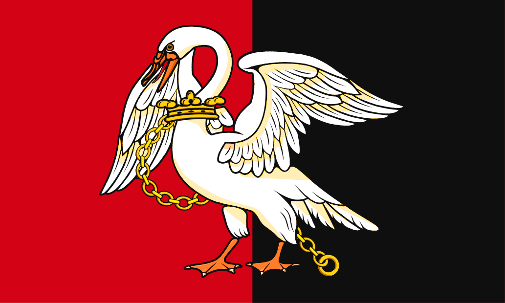
Buckinghamshire takes its name from its original county town, Buckingham, whose name in turn is form the Old English Buccingaham ("Bucca's kin's home"). Buckinghamshire first appears in the Anglo-Saxon Chronicle (as Buccingahamscir) in 1010. The traditional flag of Buckinghamshire features a chained swan on a bicolour of red and black. The swan emblem dates back to Anglo-Saxon times, when Buckinghamshire was known for breeding swans for the king. The flag has been in use for centuries. Buckinghamshire Day is celebrated annually on July 29th, chosen to commemorate the first ever Stoke Mandeville Games in 1948. The Games, originally held for servicemen who had suffered injuries, became the precursors of the Paralympic Games.