
 Menu
MenuSearch the Gazetteer
Are the results not as expected? Modify your search term or change the scope to refine your search.
Results for a place that exactly matches ...
Brecknockshire
Brecknockshire, Wales
Brecknockshire (Sir Frycheiniog), also known as Breconshire, is a mountainous county in Mid-Wales. The far south of Brecknockshire stands at the heads of the Valleys and includes Cefn-Coed-y-Cymmer, Beaufort and Brynmawr. The Black Mountains occupy the southeast of the county, the Brecon Beacons the central part of the south, Fforest Fawr the southwest and Mynydd Eppynt the north. The central part of the county is dominated by the valley of the great River Usk. The county town, Brecon, houses Brecon Cathedral and the Shire Hall. At the eastern border of the county is the book town of Hay on Wye.
Portrait of Brecknockshire
Type: Historic County
Alternative name(s): Breconshire, Sir Frycheiniog
Lat, Long: 51.958746,-3.403187
Grid Reference: SO036298
Country: Wales
 Explore Brecknockshire on Wikishire
Brecknockshire's southern border stands along the heads of the South Wales Valleys. Several towns and villages in this area lie in Brecknockshire. The village of Cefn-Coed-y-Cymmer lies north of the Taf Fawr and Taf Fechan, the border with Glamorgan. The impressive Cefn Coed Viaduct, completed in 1866, crosses the Taf Fawr from Brecknockshire into Glamorgan.

Cefn Coed Viaduct
Further east, above the Monmouthshire valleys, lie the villages of Rassau, Carmeltown and Beaufort, the last formed following the establishment of the Beaufort Iron Works in 1779. The market town of Brynmawr grew with the development of the nearby Nantyglo ironworks (in Monmouthshire) in the early 19th century. The Brynmawr Experiment was an effort to address the poverty and unemployment in the town during the 1930s. Among the small industries it spawned was the Brynmawr Furniture Makers Ltd. The Market Hall Cinema is claimed to be the longest continually running cinema in Wales.
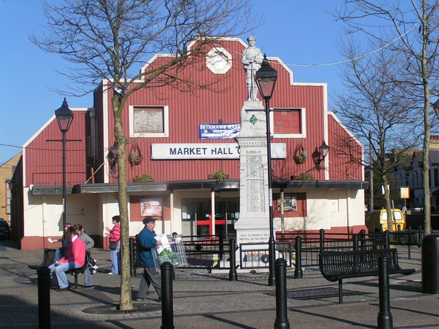
Brynmawr War Memorial and Market Hall
Across the south of the county are three mountains ranges. All three ranges form part of the Brecon Beacons National Park. In the south-west, the Black Mountain range straddles into Brecknockshire from Carmarthenshire. The highest point is Fan Brycheiniog (2,631 ft). South of the Black Mountain, on the River Tawe, lies Ystradgynlais. The town grew around the iron-making, coal-mining and watch-making industries.

Fan Brycheiniog
To the east of the Black Mountain range is Fforest Fawr or the Great Forest of Brecknock, a former royal hunting area. There are several peaks over 2,000 ft including Fan Fawr (2,408 ft). Within Fforest Fawr are the spectacular Henrhyd Falls and the Dan-yr-Ogof showcaves.

Henrhyd Falls
East of the Merthyr to Brecon road (A470), stretch the Brecon Beacons, including the county top Pen y Fan (2,900 feet). Other notable summits include Corn Du (2,864 feet), Cribyn (2,608 feet), and Fan y Big (2,359 feet). These summits form a long ridge which forms a horseshoe around the head of the Taf Fechan. Llangorse Lake, the county’s largest natural lake, lies deep with the Brecon Beacons. The lake is famed in folklore and home to an “afanc” (lake monster) nicknamed ‘Gorsey’.

Llangorse Lake from Allt yr Esgair
The central part of the county is dominated by the valley of the great River Usk. The Usk rises in the Black Mountain range, forming the border with Cardiganshire before turning east into Brecknockshire. A great diversity of plants and animal life dwell in and along the Usk.
The Usk flows south of the village of Trecastle, named after its 11th-century Norman motte-and-bailey fortification. On the summit of Trecastle Mountain is 'Y Pigwn', two overlaying Roman practice marching camps. There are also two stone circles. At the village of Sennybridge the Usk is joined by the Afon Senni.

Trecastle Mountain stone circle
Y Gaer (Cadw) is a Roman fort built around AD 75, sitting on a crossroads of Roman roads in the Usk valley. It was manned by highly trained legionaries of the Vettonian Spanish Cavalry Regiment. Now in quiet countryside, in Roman times this was a busy site, with a large guardhouse, granary and heated bathhouse.

Brecon Castle
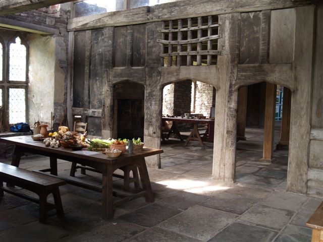
The county town, Brecon, lies where the Usk is joined by the Honddu. The confluence of the rivers made for a valuable defensive position for the Norman castle which overlooks the town. North of the castle stands Brecon Cathedral, built on the orders of Bernard de Neufmarché, the Norman conquerer of Brycheiniog. The Usk Bridge, which carries the B4601 over the river, was built in 1563 and painted by Turner c.1769. The Brecknockshire Shire Hall, opened in 1842, houses the county museum and its remarkable Victorian court room. The town has a long association with the military and houses the Regimental Museum of the Royal Welsh. Theatr Brycheiniog is located on Canal Wharf, alongside the Monmouthshire and Brecon Canal, which runs from Brecon for 35 miles to Pontymoile in Monmouthshire. The Brecon Jazz Festival is held each year in August.

Brecknockshire Shire Hall
After Brecon, the Usk heads south-east to the small town of Crickhowell. The Usk is bridged here by an elegant 17th-century stone bridge. Also within the town are the 14th-century parish church of St Edmund, and the ruins of Crickhowell Castle.

Crickhowell Castle
North of Crickhowell are the ruins of Tretower Castle (Cadw). The castle was founded as a motte and bailey castle by Picard, a follower of Bernard de Neufmarche, with a stone shell and tower added later. In the early 14th century residential buildings were constructed away from the original fortifications forming Tretower Court (Cadw). Over time the lords of Tretower favoured the more luxurious Court and the castle fell into disuse.
Tretower Court
South of Crickhowell, in the Usk valley, lies the village of Gilwern, once an important industrial centre due to its location beside the Monmouthshire and Brecon canal. To the west, the River Clydach rises on Llangattock Mountain and flows south-east through the spectacular Clydach Gorge before joining the Usk at Gilwern. The village of Clydach was the site of a major ironworks. The Usk leaves Brecknockshire and heads into Monmouthshire just south of Gilwern.

Clydach Gorge ironworks
To the east of the Usk Valley lie the Black Mountains (not to be confused with the Black Mountain range). These cross over into Monmouthshire and Herefordshire, though the highest mountain Waun Fach (2,661 feet) is in Brecknockshire. The peak and ridge of Black Mountain (2,306 feet) forms the Brecknockshire – Herefordshire border, the summit forming the county top of Herefordshire.

View from Lord Hereford's Knob in the Black Mountains
North of the Usk Valley is an upland plateau known as the Mynydd Epynt. To the north of that, the valley of the River Irfon flows from west to east across the county, joining the Wye at Builth Wells. Llanwrtyd Wells developed as a spa town following the discovery in 1732, by the Rev Theophilus Evans, of waters claimed to have amazing healing properties.

Bridge over River Irfon at Llanwrtyd Wells
In the north-west of the county lie the Cambrian Mountains. The River Wye forms the Radnorshire border from south of Rhayader. The ford of the Wye at Builth Wells was the main north-south route in Wales. The bridge over the A470 still performs this role. Builth Castle was built under Edward I. The only remains are huge earthworks. The town added "Wells" in the 19th century when its springs were promoted as a visitor attraction.

The Wye Bridge at Builth Wells. Brecknockshire is on the right bank and Radnorshire on the left bank
The small town of Talgarth lies between the Wye and the Black Mountains. Notable buildings include its 14th-century parish church and a 13th century pele tower. Nearby Bronllys Castle (Cadw) is a motte and bailey fortress first constructed around 1100.

Bronllys Castle keep
Just east of the town of Hay-on-Wye, the Dulas Brook flows into the Wye at the point where Brecknockshire, Radnorshire and Herefordshire meet. Hay-on-Wye is famous for its large number of second-hand bookshops, describing itself as "The Towns of Books". The Hay Festival has become a prominent festival in British culture.

Butter Market, Hay-on-Wye
Brycheiniog was an independent kingdom in the Early Middle Ages. The exact origins of Brycheiniog are unclear but the name is thought to derive from Brychan mac Anlach, the 5th-century ruler of the area. Over the succeeding centuries many dynasties ruled the kingdom, alliances were made and broken, victories won and defeats suffered, but the kingdom maintained its integrity and identity up to Norman times. Bernard de Neufmarché was a minor Norman lord who successfully undertook the conquest of the Kingdom of Brycheiniog between 1088 and 1095. Bernard established a Marcher Lordship in its place – the Lordship of Brecknock. By the early Tudor period, the lordship was ruled by the Earls of Buckingham. When Edward Stafford, 3rd Duke of Buckingham, was executed for treason, the Lordship was forfeited to the crown. Henry VIII combined it with the cantref of Buellt. By the Laws in Wales Acts 1535, Henry VIII converted the combined territory into the county of Brecknock.

The Brecknockshire flag at the county border
Brecknockshire does not currently have a county flag registered with the Flag Institute. The proposed Brecknockshire flag is derived from the arms assigned to Brychan in the later mediæval period and later informally adopted by Brecknockshire County Council.
Portrait of Brecknockshire
Type: Historic County
Alternative name(s): Breconshire, Sir Frycheiniog
Lat, Long: 51.958746,-3.403187
Grid Reference: SO036298
Country: Wales
Explore Brecknockshire on WikishireBrecknockshire's southern border stands along the heads of the South Wales Valleys. Several towns and villages in this area lie in Brecknockshire. The village of Cefn-Coed-y-Cymmer lies north of the Taf Fawr and Taf Fechan, the border with Glamorgan. The impressive Cefn Coed Viaduct, completed in 1866, crosses the Taf Fawr from Brecknockshire into Glamorgan.

Cefn Coed Viaduct
Further east, above the Monmouthshire valleys, lie the villages of Rassau, Carmeltown and Beaufort, the last formed following the establishment of the Beaufort Iron Works in 1779. The market town of Brynmawr grew with the development of the nearby Nantyglo ironworks (in Monmouthshire) in the early 19th century. The Brynmawr Experiment was an effort to address the poverty and unemployment in the town during the 1930s. Among the small industries it spawned was the Brynmawr Furniture Makers Ltd. The Market Hall Cinema is claimed to be the longest continually running cinema in Wales.

Brynmawr War Memorial and Market Hall
Across the south of the county are three mountains ranges. All three ranges form part of the Brecon Beacons National Park. In the south-west, the Black Mountain range straddles into Brecknockshire from Carmarthenshire. The highest point is Fan Brycheiniog (2,631 ft). South of the Black Mountain, on the River Tawe, lies Ystradgynlais. The town grew around the iron-making, coal-mining and watch-making industries.

Fan Brycheiniog
To the east of the Black Mountain range is Fforest Fawr or the Great Forest of Brecknock, a former royal hunting area. There are several peaks over 2,000 ft including Fan Fawr (2,408 ft). Within Fforest Fawr are the spectacular Henrhyd Falls and the Dan-yr-Ogof showcaves.
.jpg)
Henrhyd Falls
East of the Merthyr to Brecon road (A470), stretch the Brecon Beacons, including the county top Pen y Fan (2,900 feet). Other notable summits include Corn Du (2,864 feet), Cribyn (2,608 feet), and Fan y Big (2,359 feet). These summits form a long ridge which forms a horseshoe around the head of the Taf Fechan. Llangorse Lake, the county’s largest natural lake, lies deep with the Brecon Beacons. The lake is famed in folklore and home to an “afanc” (lake monster) nicknamed ‘Gorsey’.

Llangorse Lake from Allt yr Esgair
The central part of the county is dominated by the valley of the great River Usk. The Usk rises in the Black Mountain range, forming the border with Cardiganshire before turning east into Brecknockshire. A great diversity of plants and animal life dwell in and along the Usk.
The Usk flows south of the village of Trecastle, named after its 11th-century Norman motte-and-bailey fortification. On the summit of Trecastle Mountain is 'Y Pigwn', two overlaying Roman practice marching camps. There are also two stone circles. At the village of Sennybridge the Usk is joined by the Afon Senni.

Trecastle Mountain stone circle
Y Gaer (Cadw) is a Roman fort built around AD 75, sitting on a crossroads of Roman roads in the Usk valley. It was manned by highly trained legionaries of the Vettonian Spanish Cavalry Regiment. Now in quiet countryside, in Roman times this was a busy site, with a large guardhouse, granary and heated bathhouse.
.jpg)
Brecon Castle
The county town, Brecon, lies where the Usk is joined by the Honddu. The confluence of the rivers made for a valuable defensive position for the Norman castle which overlooks the town. North of the castle stands Brecon Cathedral, built on the orders of Bernard de Neufmarché, the Norman conquerer of Brycheiniog. The Usk Bridge, which carries the B4601 over the river, was built in 1563 and painted by Turner c.1769. The Brecknockshire Shire Hall, opened in 1842, houses the county museum and its remarkable Victorian court room. The town has a long association with the military and houses the Regimental Museum of the Royal Welsh. Theatr Brycheiniog is located on Canal Wharf, alongside the Monmouthshire and Brecon Canal, which runs from Brecon for 35 miles to Pontymoile in Monmouthshire. The Brecon Jazz Festival is held each year in August.

Brecknockshire Shire Hall
After Brecon, the Usk heads south-east to the small town of Crickhowell. The Usk is bridged here by an elegant 17th-century stone bridge. Also within the town are the 14th-century parish church of St Edmund, and the ruins of Crickhowell Castle.

Crickhowell Castle
North of Crickhowell are the ruins of Tretower Castle (Cadw). The castle was founded as a motte and bailey castle by Picard, a follower of Bernard de Neufmarche, with a stone shell and tower added later. In the early 14th century residential buildings were constructed away from the original fortifications forming Tretower Court (Cadw). Over time the lords of Tretower favoured the more luxurious Court and the castle fell into disuse.

Tretower Court
South of Crickhowell, in the Usk valley, lies the village of Gilwern, once an important industrial centre due to its location beside the Monmouthshire and Brecon canal. To the west, the River Clydach rises on Llangattock Mountain and flows south-east through the spectacular Clydach Gorge before joining the Usk at Gilwern. The village of Clydach was the site of a major ironworks. The Usk leaves Brecknockshire and heads into Monmouthshire just south of Gilwern.

Clydach Gorge ironworks
To the east of the Usk Valley lie the Black Mountains (not to be confused with the Black Mountain range). These cross over into Monmouthshire and Herefordshire, though the highest mountain Waun Fach (2,661 feet) is in Brecknockshire. The peak and ridge of Black Mountain (2,306 feet) forms the Brecknockshire – Herefordshire border, the summit forming the county top of Herefordshire.

View from Lord Hereford's Knob in the Black Mountains
North of the Usk Valley is an upland plateau known as the Mynydd Epynt. To the north of that, the valley of the River Irfon flows from west to east across the county, joining the Wye at Builth Wells. Llanwrtyd Wells developed as a spa town following the discovery in 1732, by the Rev Theophilus Evans, of waters claimed to have amazing healing properties.

Bridge over River Irfon at Llanwrtyd Wells
In the north-west of the county lie the Cambrian Mountains. The River Wye forms the Radnorshire border from south of Rhayader. The ford of the Wye at Builth Wells was the main north-south route in Wales. The bridge over the A470 still performs this role. Builth Castle was built under Edward I. The only remains are huge earthworks. The town added "Wells" in the 19th century when its springs were promoted as a visitor attraction.
.jpg)
The Wye Bridge at Builth Wells. Brecknockshire is on the right bank and Radnorshire on the left bank
The small town of Talgarth lies between the Wye and the Black Mountains. Notable buildings include its 14th-century parish church and a 13th century pele tower. Nearby Bronllys Castle (Cadw) is a motte and bailey fortress first constructed around 1100.

Bronllys Castle keep
Just east of the town of Hay-on-Wye, the Dulas Brook flows into the Wye at the point where Brecknockshire, Radnorshire and Herefordshire meet. Hay-on-Wye is famous for its large number of second-hand bookshops, describing itself as "The Towns of Books". The Hay Festival has become a prominent festival in British culture.

Butter Market, Hay-on-Wye
Brycheiniog was an independent kingdom in the Early Middle Ages. The exact origins of Brycheiniog are unclear but the name is thought to derive from Brychan mac Anlach, the 5th-century ruler of the area. Over the succeeding centuries many dynasties ruled the kingdom, alliances were made and broken, victories won and defeats suffered, but the kingdom maintained its integrity and identity up to Norman times. Bernard de Neufmarché was a minor Norman lord who successfully undertook the conquest of the Kingdom of Brycheiniog between 1088 and 1095. Bernard established a Marcher Lordship in its place – the Lordship of Brecknock. By the early Tudor period, the lordship was ruled by the Earls of Buckingham. When Edward Stafford, 3rd Duke of Buckingham, was executed for treason, the Lordship was forfeited to the crown. Henry VIII combined it with the cantref of Buellt. By the Laws in Wales Acts 1535, Henry VIII converted the combined territory into the county of Brecknock.

The Brecknockshire flag at the county border
Brecknockshire does not currently have a county flag registered with the Flag Institute. The proposed Brecknockshire flag is derived from the arms assigned to Brychan in the later mediæval period and later informally adopted by Brecknockshire County Council.