
 Menu
MenuSearch the Gazetteer
Are the results not as expected? Modify your search term or change the scope to refine your search.
Results for a place that exactly matches ...
Argyllshire
Argyllshire, Scotland
Argyll is a maritime county of breathtaking, mountainous scenery, encompassing most of the Inner Hebrides (including Jura, Islay, Mull, Colonsay, Coll and Tiree) and the entire western coast of Scotland between the Mull of Kintyre and the Ardnamurchan peninsula. The county is deeply cut by sea lochs, and divided into peninsulas and scattered islands stretching into the Atlantic. The lochs of the mainland part of the county divide it into distinctive districts, including Ardnamurchan, Morvern, Lorne, Argyll, Cowal, Knapdale and Kintyre.
Portrait of Argyllshire
Place Type: Historic County
Lat, Long: 56.133328,-5.474798
Grid Reference: NR841988
Country: Scotland
GBPNID: 305772
Entry Type: Main listing (P)
URL: https://gazetteer.org.uk/place/Argyllshire,_305772
 Explore Argyllshire on Wikishire
The Ardnamurchan peninsula is noted for being unspoiled. Ardnamurchan Point has the 118ft Ardnamurchan Lighthouse. Nearby Corrachadh Mòr is the most westerly point of Great Britain.
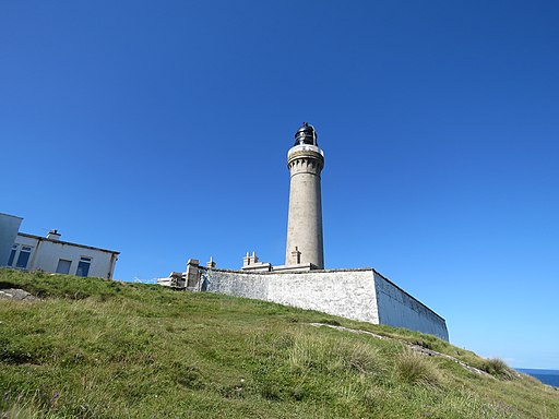
Ardnamurchan Lighthouse
Morven or Morvern is bounded by Loch Sunart, Loch Linnhe and the Sound of Mull. The spectacular ruins of Ardtornish Castle lie on a promontory extending into the Sound. Kinlochaline Castle is a 15th-century Scottish tower house. The main village of Lochaline is a ferry port for the Isle of Mull.
Appin lies to the east of Loch Linnhe, between Loch Creran and Loch Leven. Ballachulish and Port Appin are the principal villages. Glencoe or Glen Coe, one of the most spectacular and beautiful places in the Highlands, has a bloody mark in history for the Glencoe massacre of 13 February 1692. Castle Stalker is a four-storey tower house or keep picturesquely set on a tidal islet on Loch Laich.

Glen Coe Pass
Benderloch lies between Loch Creran and Loch Etive. The name is derived from Beinn eadar dà loch, meaning "mountain between two lochs". The village of the same name grew up as the railway line from Ballachullish to Connel was completed in the early part of the 1900s. The Connel Bridge across Loch Etive connects Benderloch to Lorne.
Lorne includes the Atlantic coast surrounding Loch Etive. Its single town, standing on the Firth of Lorn, is Oban, the "Gateway to the Isles" from which ferries sail for the Hebrides. Dunollie Castle is a small, ruined castle located on a hill north of the town, the site enjoying fine view of the town, harbour, Kerrera and outlying isles. Dunstaffnage Castle (HES) lies three miles north of Oban, on a platform of conglomerate rock on a promontory at the south-west of the entrance to Loch Etive, surrounded on three sides by the sea. The castle is one of Scotland's oldest stone castles, dating back to the 13th century.
To the south of Lorne is Knapdale, between the Sound of Jura and Loch Fyne. Castle Sween (HES), on the eastern shore of Loch Sween, is thought to be one of the earliest stone castles built in Scotland, having been built at some time in the late 12th century.
Castle Sween
South of Knapdale is Kintyre, a long narrow peninsula the southernmost point of which is known as the Mull. Skipness Castle, on the east side of the Kintyre Peninsula, was built in the early 13th century by the Clan MacSween with later fortifications and other additions made to the castle through the 13th, 14th and 16th centuries.
The district of Argyll lies in the middle of the shire, including the county town, Inverary, ancestral home to the Duke of Argyll. Inverary Castle is a classic Georgian mansion house on a grand scale. Dunderave Castle is an L-plan castle built in the 16th century as the seat of the MacNaughton clan. The castle lies on a small promontory on the northern shores of Loch Fyne. Kilchurn Castle (HES), lying on a rocky peninsula at the north-eastern end of Loch Awe, was first constructed in the mid-15th century as the base of the Campbells of Glenorchy, who extended both the castle and their territory in the area over the next 150 years.
South of Argyll lies Cowall, between Loch Fyne, Loch Long and the Firth of Clyde. In its north is the mountainous Argyll Forest Park. In its south is the resort town of Dunoon. Castle Lachlan, or New Castle Lachlan, is an 18th-century baronial mansion or country house located at Strathlachlan. It was built in 1790 by Donald Maclachlan, 19th laird, to replace the 15th century Old Castle Lachlan, which stands nearby on the shores of Loch Fyne. Carrick Castle is a 15th-century tower house on the west shore of Loch Goil.

Old Castle Lachlan
The county embraces most of the Inner Hebrides. Of the Small Isles, Canna, Rùm and Muck are part of Argyllshire. Rum, the largest, has a small population in Kinloch but is an important study site for ecology and the site of the successful reintroduction of the white-tailed sea eagle.
Col is a flat, peaceful island with one village, Arinagour. The isle is rich in wildlife. It forms a pair with Tiree, the most westerly inhabited island in the Inner Hebrides.
Mull is the largest of Argyllshire's islands, with 298 miles of coastline. The island has a mountainous core, the highest peak on the island being Ben More (3,169 feet). The capital, Tobermory, famous for the brightly painted assorted colours on its Main Street, lies near the northern entrance of the Sound of Mull. The island is rich in wildlife, a stronghold of the white-tailed sea eagle. Offshore are basking sharks, minke whales, porpoises and dolphins.

Tobermory
Iona, west of Mull, is world famous as the first centre of St Columba’s mission to bring Christianity to the Scots and Picts. The ruins of the Abbey were restored by the 8th Duke of Argyll in the 19th century. Iona today is renowned for its tranquillity and natural beauty. Fingal's Cave is a famous sea cave on the uninhabited island of Staffa.
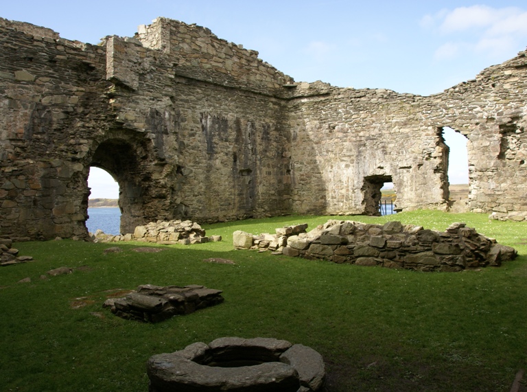
South of Mull lies Colonsay, its single village Scalasaig on the east coast. The island abounds in historic sites, including the Dùn Cholla and Dùn Meadhonach ruined hill forts, the 8th-century Riasg Buidhe Cross and the 14th-century St Cathan's Chapel.

St Cathan's Chapel, Colonsay
Jura is a large island dominated by three steep-sided conical quartzite mountains on its western side – the Paps of Jura - which rise to 2,575 feet. The village of Craighouse is home to the Isle of Jura distillery. South of Jura is Islay, "The Queen of the Hebrides". The capital is Bowmore, Port Ellen the main port. The island is sparsely populated and mainly agricultural. The island is rich in birdlife as well as grey seals, otters and red deer. There are eight distilleries.
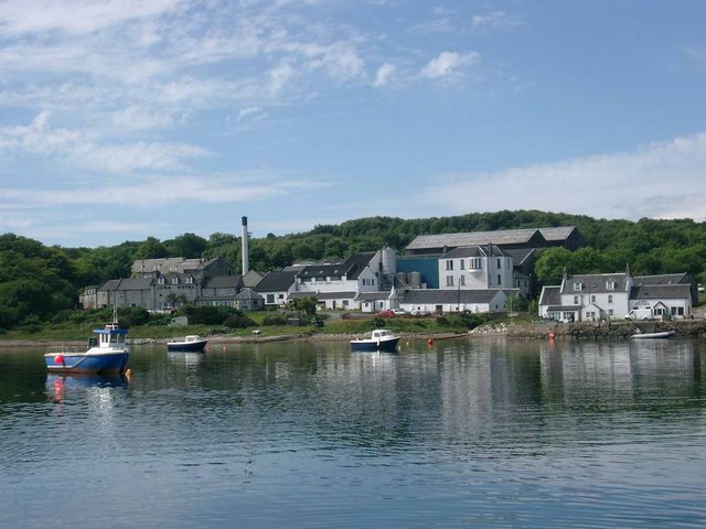
Isle of Jura Distillery
The name of Argyll is an ancient one; the Borderland of the Gael. It approximates to the first Kingdom of the Scots, Dalriada, which through later conquest and accretion spread to become Scotland. The sheriffdom of Argyll was created in 1326 to oversee the forfeited MacDougall territory of Lorne, though the southern parts of Argyllshire remained part of the Lordship of the Isles until the late 15th century.
Portrait of Argyllshire
Place Type: Historic County
Lat, Long: 56.133328,-5.474798
Grid Reference: NR841988
Country: Scotland
GBPNID: 305772
Entry Type: Main listing (P)
URL: https://gazetteer.org.uk/place/Argyllshire,_305772
Explore Argyllshire on WikishireThe Ardnamurchan peninsula is noted for being unspoiled. Ardnamurchan Point has the 118ft Ardnamurchan Lighthouse. Nearby Corrachadh Mòr is the most westerly point of Great Britain.

Ardnamurchan Lighthouse
Morven or Morvern is bounded by Loch Sunart, Loch Linnhe and the Sound of Mull. The spectacular ruins of Ardtornish Castle lie on a promontory extending into the Sound. Kinlochaline Castle is a 15th-century Scottish tower house. The main village of Lochaline is a ferry port for the Isle of Mull.
Appin lies to the east of Loch Linnhe, between Loch Creran and Loch Leven. Ballachulish and Port Appin are the principal villages. Glencoe or Glen Coe, one of the most spectacular and beautiful places in the Highlands, has a bloody mark in history for the Glencoe massacre of 13 February 1692. Castle Stalker is a four-storey tower house or keep picturesquely set on a tidal islet on Loch Laich.

Glen Coe Pass
Benderloch lies between Loch Creran and Loch Etive. The name is derived from Beinn eadar dà loch, meaning "mountain between two lochs". The village of the same name grew up as the railway line from Ballachullish to Connel was completed in the early part of the 1900s. The Connel Bridge across Loch Etive connects Benderloch to Lorne.
Lorne includes the Atlantic coast surrounding Loch Etive. Its single town, standing on the Firth of Lorn, is Oban, the "Gateway to the Isles" from which ferries sail for the Hebrides. Dunollie Castle is a small, ruined castle located on a hill north of the town, the site enjoying fine view of the town, harbour, Kerrera and outlying isles. Dunstaffnage Castle (HES) lies three miles north of Oban, on a platform of conglomerate rock on a promontory at the south-west of the entrance to Loch Etive, surrounded on three sides by the sea. The castle is one of Scotland's oldest stone castles, dating back to the 13th century.
To the south of Lorne is Knapdale, between the Sound of Jura and Loch Fyne. Castle Sween (HES), on the eastern shore of Loch Sween, is thought to be one of the earliest stone castles built in Scotland, having been built at some time in the late 12th century.

Castle Sween
South of Knapdale is Kintyre, a long narrow peninsula the southernmost point of which is known as the Mull. Skipness Castle, on the east side of the Kintyre Peninsula, was built in the early 13th century by the Clan MacSween with later fortifications and other additions made to the castle through the 13th, 14th and 16th centuries.
The district of Argyll lies in the middle of the shire, including the county town, Inverary, ancestral home to the Duke of Argyll. Inverary Castle is a classic Georgian mansion house on a grand scale. Dunderave Castle is an L-plan castle built in the 16th century as the seat of the MacNaughton clan. The castle lies on a small promontory on the northern shores of Loch Fyne. Kilchurn Castle (HES), lying on a rocky peninsula at the north-eastern end of Loch Awe, was first constructed in the mid-15th century as the base of the Campbells of Glenorchy, who extended both the castle and their territory in the area over the next 150 years.
South of Argyll lies Cowall, between Loch Fyne, Loch Long and the Firth of Clyde. In its north is the mountainous Argyll Forest Park. In its south is the resort town of Dunoon. Castle Lachlan, or New Castle Lachlan, is an 18th-century baronial mansion or country house located at Strathlachlan. It was built in 1790 by Donald Maclachlan, 19th laird, to replace the 15th century Old Castle Lachlan, which stands nearby on the shores of Loch Fyne. Carrick Castle is a 15th-century tower house on the west shore of Loch Goil.

Old Castle Lachlan
The county embraces most of the Inner Hebrides. Of the Small Isles, Canna, Rùm and Muck are part of Argyllshire. Rum, the largest, has a small population in Kinloch but is an important study site for ecology and the site of the successful reintroduction of the white-tailed sea eagle.
Col is a flat, peaceful island with one village, Arinagour. The isle is rich in wildlife. It forms a pair with Tiree, the most westerly inhabited island in the Inner Hebrides.
Mull is the largest of Argyllshire's islands, with 298 miles of coastline. The island has a mountainous core, the highest peak on the island being Ben More (3,169 feet). The capital, Tobermory, famous for the brightly painted assorted colours on its Main Street, lies near the northern entrance of the Sound of Mull. The island is rich in wildlife, a stronghold of the white-tailed sea eagle. Offshore are basking sharks, minke whales, porpoises and dolphins.

Tobermory
Iona, west of Mull, is world famous as the first centre of St Columba’s mission to bring Christianity to the Scots and Picts. The ruins of the Abbey were restored by the 8th Duke of Argyll in the 19th century. Iona today is renowned for its tranquillity and natural beauty. Fingal's Cave is a famous sea cave on the uninhabited island of Staffa.
South of Mull lies Colonsay, its single village Scalasaig on the east coast. The island abounds in historic sites, including the Dùn Cholla and Dùn Meadhonach ruined hill forts, the 8th-century Riasg Buidhe Cross and the 14th-century St Cathan's Chapel.

St Cathan's Chapel, Colonsay
Jura is a large island dominated by three steep-sided conical quartzite mountains on its western side – the Paps of Jura - which rise to 2,575 feet. The village of Craighouse is home to the Isle of Jura distillery. South of Jura is Islay, "The Queen of the Hebrides". The capital is Bowmore, Port Ellen the main port. The island is sparsely populated and mainly agricultural. The island is rich in birdlife as well as grey seals, otters and red deer. There are eight distilleries.

Isle of Jura Distillery
The name of Argyll is an ancient one; the Borderland of the Gael. It approximates to the first Kingdom of the Scots, Dalriada, which through later conquest and accretion spread to become Scotland. The sheriffdom of Argyll was created in 1326 to oversee the forfeited MacDougall territory of Lorne, though the southern parts of Argyllshire remained part of the Lordship of the Isles until the late 15th century.