Search the Gazetteer
Are the results not as expected? Modify your search term or change the scope to refine your search.
Results for a place that exactly matches ...
Wiltshire
Wiltshire, England
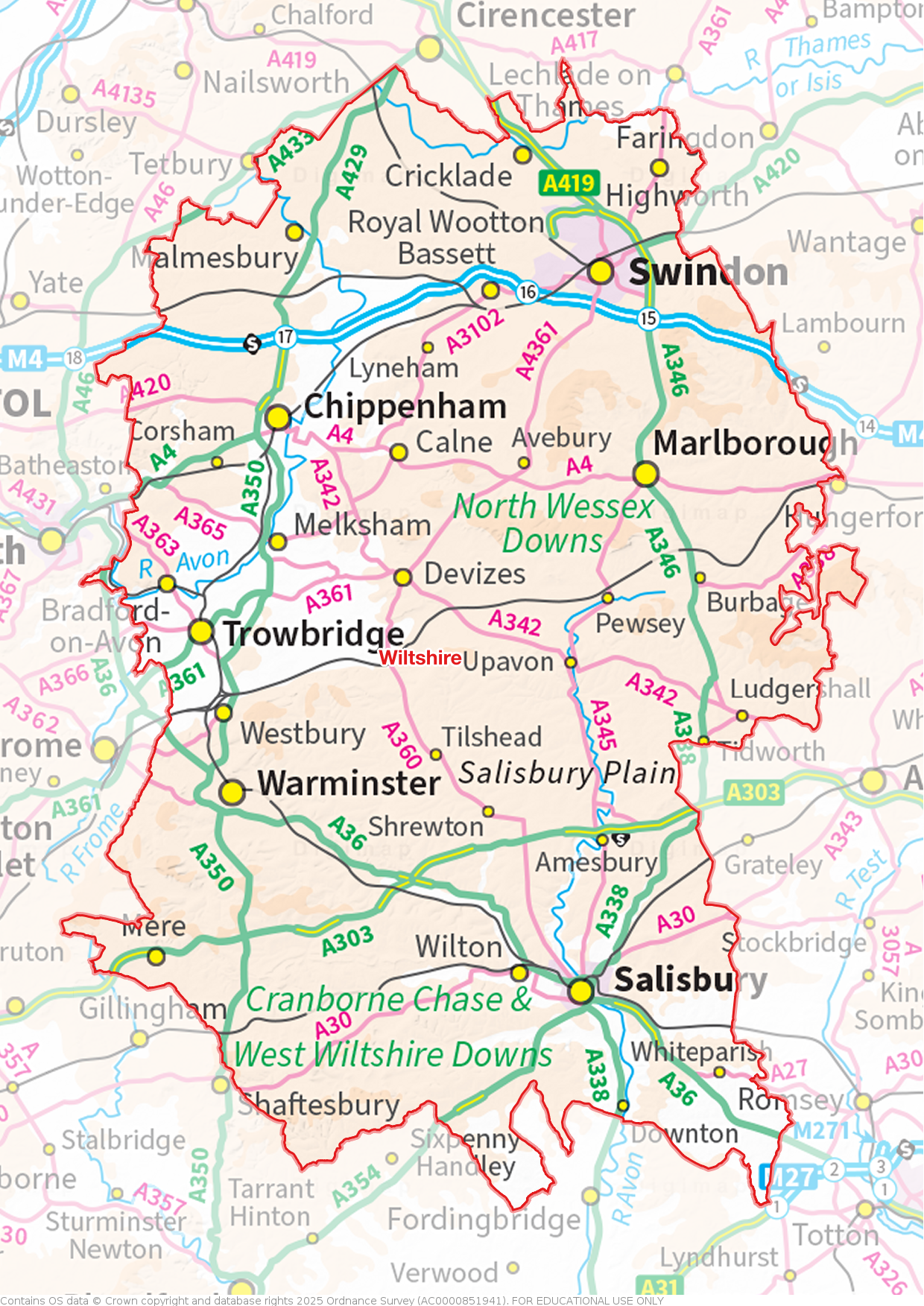
 Wiltshire is an inland county in the south of England. The City of Salisbury lies in the county's south-east, a mediæval "new town" built around an ornate cathedral. Nearby is the ancient county town of Wilton, location of the magnificent Wilton House. Salisbury Plain stretches across almost the entire width of the county, home to Stonehenge and many other ancient landscape features. North of the Plain, the Vale of Pewsey is a beautiful agricultural landscape of small villages and fertile fields. To its north, the chalk hills of the Marlborough Downs sweep across the county, creating a hauntingly beautiful landscape littered with evidence of forgotten peoples. The most famous monuments are the Avebury ring and Silbury Hill. In the north-east of the county is Swindon, an ancient place but transformed by the Great Western Railway. The north-west lies in the Cotswolds, Malmesbury being a delightful Cotswolds town. The River Avon flows through the west of the county - Chippenham, Melksham, Bradford on Avon and Trowbridge lying along its valley. In the south-west are the garrison town of Warminster and Westbury, famous for its White Horse.
Portrait of Wiltshire
Place Type: Historic County
Lat, Long: 51.083627,-1.901459
Grid Reference: SU 0699 3159
Country: England
GBPNID: 305769
GGA Code: C01000090
Entry Type: Main listing (P)
URL: https://gazetteer.org.uk/place/Wiltshire
 Explore Wiltshire on Wikishire
Southern Wiltshire is known for pretty towns and villages. In the county's south-east is the City of Salisbury, a mediæval "new town", built around an ornate cathedral; the cathedral with the highest spire in Britain. The cathedral Close, in which are the most exclusive houses, is renowned. The origin of the city is found on a hill to the north: Old Sarum, a city since the iron age, now abandoned.

Old Sarum
The far south-east of the county is a highly wooded landscape including Tytherley Forest, known for its abundance of butterfly species. South of this is Langley Wood, which forms the tip of the New Forest, spreading into Wiltshire from Hampshire. Plaitford Common (NT) consists chiefly of rough grassland.
To the west of Salisbury is the ancient county town of Wilton. Wilton dates back to the Anglo-Saxons in the 8th century AD, and by the late-9th century it was the capital of 'Wiltunscir'. Wilton Abbey was surrendered to Henry VIII during the Dissolution and granted to the Earl of Pembroke who began the process of transforming the abbey into the magnificent Wilton House.

Wilton House
Cranborne Chase, the relict of an ancient hunting forest, stretches from Dorset north-eastward into Wiltshire almost to Wilton. This is an agricultural landscape characterised by large, open fields punctuated by blocks of woodland all draped over the undulating chalk topography. The West Wiltshire Downs lie alongside the River Nadder to the west of Wilton, an area of open chalk downland with some significant ancient woodlands. Between the downlands is the Vale of Wardour, the valley of the River Nadder. The vale is named after the village of Wardour though its largest village is Tisbury. Place Farm is a complex of mediæval buildings which originally formed a grange of Shaftesbury Abbey. The tithe barn, at 200ft long, is reputed to be the largest barn in England.

Tithe Barn, Place Farm, Tisbury
In the south-west of the county, close to the Somerset border, are the small town of Mere and the garrison town of Warminster. Warminster has several bath stone houses including Portway House, built for a wealthy clothier in 1722. Nearby Westbury is famous for its White Horse which overlooks the town from a slope up to Salisbury Plain. To the west of these towns lies Longleat, a grand stately home and seat of the Marquesses of Bath. Longleat Safari Park opened in 1966, the first drive-through safari park outside Africa.

The Lions of Longleat
North of Salisbury, stretching across almost the entre width of the county, is Salisbury Plain, the largest area of chalk in the county, some 300 square miles of it, a semi-wilderness used mainly for arable farming and by the Army as training ranges. The Plain is home to Stonehenge, and many ancient burial mounds and manmade features whose origins are lost in the mists of time, such that the whole spread has been termed a ‘sacred landscape’. The town of Amesbury stands on the southern edge of the great plain.

Stonehenge
North of Salisbury Plain, in the east of the county, is the Vale of Pewsey, a broad valley through which flows the River Avon. Centred on the picturesque village of Pewsey, the Vale is a beautiful agricultural landscape of small villages and fertile fields. The Kennet and Avon canal runs through the Vale and acts as an important wildlife haven and corridor. Devizes, at the western end of the Vale of Pewsey, developed around the 11th-century Devizes Castle. It later grew on its textile industry and its corn market. The town has many notable buildings. The town has been home to the Wadworth Brewery since 1875.
North of the Vale of Pewsey, the high chalk hills of the Marlborough Downs sweep across the county from the Berkshire border, extending westwards to the Anglo-Saxon town of Calne. This is a hauntingly beautiful landscape of open hills, broad valleys and clear airs. It is full of mystery, littered with earthworks, stone circles and hillforts of forgotten peoples. The most famous monuments are the Avebury ring and Silbury Hill. The county top, Milk Hill (967 feet), is the location of the Alton Barnes White Horse, cut in 1812. The River Kennet rises in these hills and forms a valley down to Marlborough in their midst. Marlborough claims to have the widest main street in the country. Littlecote House is an Elizabethan country house standing on the banks of the Kennet.

Avebury
North of the downs lies Swindon, perhaps an ancient place but transformed by the Great Western Railway and in the 20th century developed greatly as an “Expanded Town”. The Museum of the Great Western Railway is located at the site of the old railway works. The market town of Highworth, six miles north-east of Swindon, is notable for its Queen Anne and Georgian buildings.

The Cheltenham Flyer at the Museum of the Great Western Railway, Swindon
Though the River Thames rises just across the border in Gloucestershire (at Thames Head), the river quickly enters Wiltshire and flows across the north of the county to Cricklade, the first downstream town on the Thames. The river then becomes the border with Gloucestershire before it becomes the Gloucestershire - Berkshire border. The Thames floodplain is a mix of arable farming, wet pasture and rare traditional hay meadows. The Cotswold Water Park is a series of wildlife-rich lakes created through the restoration and flooding of mineral extraction sites. South of the Thames and east of Swindon is the Forest of Braydon, the remnant of a once vast historic royal hunting forest. The landscape still has substantial areas of ancient woodland alongside wood-pasture, unimproved neutral grassland and traditional hay meadows.

Webbs Wood, a surviving fragment of the Forest of Braydon
The River Avon also rises in Gloucestershire but quickly enters Wiltshire, the Wiltshire village of Luckington being the first settlement on the river. The river flows first east though Malmesbury and then turns south and flows to Chippenham. The river's wide vale here is known as the Avon Vale, a rolling landscape of clay lowlands and open clay vales. Chippenham, established on a crossing of the River Avon, may have existed in some form since before Roman times. A former royal vill, it is today a major commuter town. Melksham also developed around a ford across the Avon. An area of the town, now known as The Spa, was developed as a spa in the 19th century. The town's four-span bridge over the Avon is from the late 18th century. Lacock Abbey (NT), between Melksham and Chippenham, is famous for its role in the invention of photography and houses the Fox Talbot Museum.

Lacock Abbey cloisters
Bradford-on-Avon has Roman origins but grew due to the woollen textile industry. Great Chalfield Manor (NT) is a late mediæval manor house near Bradford on Avon, described by Pevsner as "one of the most perfect examples of the late mediæval English manor house". Trowbridge lies on the River Biss, close to its confluence with the Avon. The town developed as a centre for woollen cloth production from the 14th century. Such was its prominence in the industry that it gained the nickname "The Manchester of the West".
The north-west of the county lies in the Cotswolds. Malmesbury is a delightful Cotswolds market town at whose heart is its vast and ancient church, Malmesbury Abbey. Corsham is an historic market town which is now a major administrative and manufacturing centre for the Ministry of Defence. Nearby Corsham Court is notable for its fine art collection. The village of Castle Combe is renowned for its attractiveness, tranquillity and fine buildings.

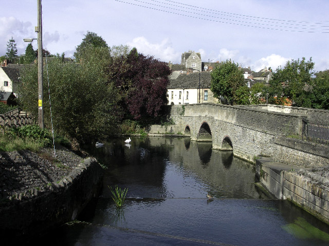
St John's Bridge over the Avon at Malmesbury
Wiltshire is famed for its white horses, the chalk downs of Wiltshire being an ideal place for such hill figures. Eight of these magnificent hill figures are still visible and another five have been overgrown and "lost". The oldest is the Westbury White Horse. The present horse was constructed in 1778 by a Mr George Gee, completely obliterating a much older horse reputedly cut in the 9th century. The Cherhill White Horse, beneath the Oldbury Castle earthwork, was constructed in 1870. The other older horses are those at Marlborough (1804), Alton Barnes (1812), Hackpen (1838) and Broad Town (1864).

Cherhill White Horse
The English conquest of the area which became Wiltshire began in AD 552 with the victory of the Saxon Cynric over the native Britons at Old Sarum. Four years later, Cynric extended the limits of the West Saxon kingdom to the Marlborough Downs by a victory at Barbury Hill. The West Saxon colonisation was initially confined to the valleys of the River Avon and the River Wylye. The little township of Wilton which arose in the Wylye valley gave the name of Wilsætan to the new settlers. By the 9th century the district had become an administrative and territorial unit. The oldest recorded mention of the name, as 'Wiltunscir', was by Asser in 878.
The local nickname for Wiltshire natives is moonrakers. Legend tells of a band of smugglers who foiled the Excise men by hiding their untaxed brandy in kegs, in a village pond. When confronted by the Excise men, the smugglers raked the surface to conceal the submerged contraband with ripples, and claimed that they were trying to rake in a large round cheese visible in the pond, really a reflection of the full moon. The officials took them for simple yokels and left them alone.
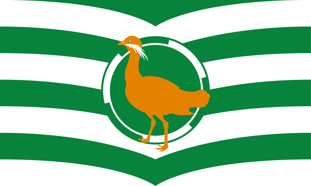
The Wiltshire flag features a Great Bustard, a bird native to the county, which had been extinct since 1832 but has recently been successfully reintroduced on Salisbury Plain. An alternative Wiltshire flag, regarded by some as more cultural connected to the county, is a depiction of the iconic Cherhill White Horse on a green background. Wiltshire Day is celebrated each 5th June.


 Menu
Menu