Search the Gazetteer
Are the results not as expected? Modify your search term or change the scope to refine your search.
Results for a place that exactly matches ...
Cambridgeshire
Cambridgeshire, England
 Cambridgeshire is an inland county of East Anglia. The south of the county is dominated by the city of Cambridge and its ancient university. The beautiful old colleges sit on mediæval streets and their delightful “backs” look out on the banks of the River Cam. South of Cambridge is an agricultural landscape of small villages, drained by the rivers Grant and Rhee. The Gog Magog Hills are the county's highest features. The Isle of Ely, the northern part of the county, is a different world - a flat and fertile land drawn out by past generations’ labour from the Great Fen. The city of Ely stands above the fens. Ely Cathedral, the "Ship of the Fens", is visible for miles across the level fenland. North lie the Fenland market towns of Whittlesey, March and Chatteris. Wisbech has much unspoilt Georgian architecture.
Portrait of Cambridgeshire
Place Type: Historic County
Lat, Long: 52.310638,0.240599
Grid Reference: TL 5284 7042
Country: England
GBPN ID: 305763
GGA Code: C01000017
Entry Type: Main listing (P)
URL: https://gazetteer.org.uk/place/Cambridgeshire
 Explore Cambridgeshire on Wikishire
The City of Cambridge sits in southern Cambridgeshire, at the southern edge of the fenland. The University of Cambridge was founded in 1209. The city's skyline is dominated by the university's buildings: particularly the towering Gothic triumph of King's College Chapel, St John's College Chapel and the more recent Cambridge University Library. The city's beautiful old colleges sit on mediæval streets and their delightful "backs" look out on the banks of the River Cam. Cambridge is also at the heart of the high-technology region known as Silicon Fen.

Back Lawn, King's College
To the south-east of Cambridge rise the Gogmagog Hills. Wandlebury Ring is an Iron Age hillfort. Worsted Street is a rare example of a Roman road with Roman paving still in place. The county top lies at Castle Camps near the Essex border. The nearby village of Linton is known for Linton Zoo, opened in 1972.
South of Cambridge the countryside is dominated by the River Granta. The Granta enters Cambridgeshire at Ickleton and meanders past Hinxton to Duxford. The Imperial War Museum at Duxford is Britain's largest aviation museum. The Granta then flows through Whittlesford to Sawston. Sawston Hall is a Tudor manor house boasting a magnificent Great Hall complete with Elizabethan panelling and a large Tudor fireplace. After flowing between Great Shelford and Little Shelford, the Granta divides Grantchester from Trumpington, both pretty villages. Students often punt as far up as Grantchester with picnics to be spread on the meadows. The Granta here is a river which has often inspired poetry, and rightly so. The river wanders north between the Grantchester meadows, meeting the town at the village of Newnham. Below Silver Street Bridge the Granta becomes the Cam.

Imperial War Museum, Duxford
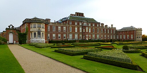
The south-west of the county is drained by the River Rhee. The Rhee enters Cambridgeshire at Hook's Mill and flows north-east through the farmland of southern Cambridgeshire, passing Little Green, Tadlow, Shingay, Wendy and Croydon. The river then passes through the Wimpole Estate. Wimpole Hall (NT) is a 17th-century country house with 3,000 acres of parkland and farmland. Below Wimpole, the Rhee passes north of Whaddon and Meldreth to reach Barrington. Below Barrington the Rhee turns north past Harston and Haslingfield to join the Granta just south of Grantchester.

Wimpole Hall
In the south-west of the county, the Icknield Way forms a stretch of the border with Hertfordshire. The town of Royston lies along this border, the northern part of the town in Cambridgeshire, though the High Street and the heart of Royston lie in Hertfordshire.
West of Cambridge, close to the Huntingdonshire border, is Cambourne, a new settlement developed from 1994 based around three villages named Great Cambourne, Lower Cambourne and Upper Cambourne.
Denny Abbey is a former abbey near Waterbeach, six miles north of Cambridge. To the north-east of the town, in the village of Lode, lies Anglesey Abbey (NT). It was once the site of a priory, dissolved at the Reformation, and developed into a Jacobean house. Further east, close to the Norfolk border, lies the impressive Dark Age earthwork known as the Devil's Dyke. It consists of a long bank and ditch that runs in a straight line for 7.5 miles from the village of Reach to Woodditton.
The northern part of Cambridgeshire, known as the Isle of Ely, is a different world from the villages of the south. This is the Great Fen, now criss-crossed by canals and dykes, the fenland drained to create exceptionally fertile agricultural land. The main rivers are the Great Ouse, the Cam and two artificial rivers, the Old and New Bedford Rivers, dug for the drainage scheme. The one remaining place which gives a sense of the old landscape is Wicken Fen, a nature reserve between Wicken and Upware with 80 acres of reedbed.

Wicken Fen
The City of Ely sits on a low hill above the fens, dominated by its cathedral. Ely Cathedral is visible for many miles across the level fenland and is known as "the Ship of the Fens". From 1107 until 1837 the Isle of Ely was under the jurisdiction of the Bishop of Ely, who exercised temporal powers within the Liberty of Ely. Although no longer used for administrative purposes, the Isle retains a geographical and cultural identity within Cambridgeshire.

Ely Cathedral
In the north of the county lie the Fenland market towns of Whittlesey, March and Chatteris. South of Whittlesey is Flag Fen, famous for its rich collection of archaeological finds. In the north-east is Wisbech, noted for its unspoilt Georgian architecture. The tidal River Nene runs through the centre of the town which was formerly a prosperous port, Peckover House (NT) is a grand merchant's house.
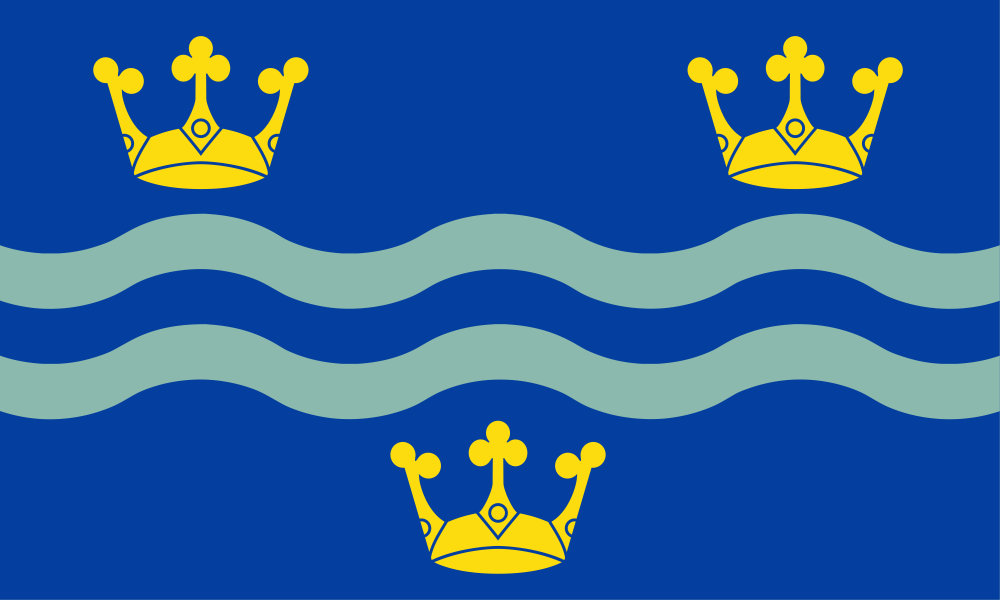
The first recorded mention of the county, as 'Grantanbrycgscir', is in the Anglo-Saxon Chronicle, which recorded its valiant resistance to the Danish invaders in 1010. The Cambridgeshire Flag was chosen by a public vote in 2015. The three gold crowns represent East Anglia. They are placed against a blue field which is the same shade used on the East Anglia flag. The wavy lines represent the River Cam and are in the colours of Cambridge University. The county flower is the striking, purple Pasqueflower, now restricted to a few chalk and limestone grasslands.


 Menu
Menu