
 Menu
MenuSearch the Gazetteer
Are the results not as expected? Modify your search term or change the scope to refine your search.
Results for a place that exactly matches ...
East Lothian
East Lothian, Scotland
 East Lothian is a maritime county, also known as Haddingtonshire, after the county town. The sea washes the county's long shoreline of 41 miles; to the north is the Firth of Forth and, rounding the corner at North Berwick, to the north-east is the North Sea. On the west is Midlothian; and to the south is Berwickshire. Broadly speaking, the northern half of the shire slopes gently to the coast, and the southern half is amongst the Lammermuir Hills.
Type: Historic County
Alternative name(s): Haddingtonshire
Lat, Long: 55.953928,-2.705674
Grid Reference: NT560736
Country: Scotland
 Explore East Lothian on Wikishire
In the north-west of the county, nearest to Edinburgh, are three commuter towns. Prestonpans lies on the firth close to the Midlothian border. It has a history dating back to the 11th century and some impressive historical architecture, including the Preston Tower, the doocot and the local Mercat Cross, which is the only one of its kind which remains in its original form and location. The town has a history of salt panning and mining but is now primarily a commuter town. Cockenzie and Port Seton has grown from what were initially two small fishing villages. Cockenzie was created in 1591 by King James VI. Port Seton harbour was built by George Seton between 1655 and 1665. The two are now indistinguishable and spoken of as one. Tranent was an important mining town, coal was first mined here in the 12th century. Fa'side Castle is a 15th-century keep found some two miles south-west of Tranent.

Mercat Cross, Prestonpans
On the most northerly stretch of the coast is the Royal Burgh of North Berwick. The town became a fashionable holiday resort in the 19th century because of its two sandy bays and continues to attract holiday makers to this day. The conical hill of North Berwick Law overlooks the town. Delightfully tumescent as it is, the hill is hard rock extruded from an ancient volcanic eruption. Tantallon Castle, a mostly ruined 14th-century fortress, lies to the east of the town. Two miles west of North Berwick stand the ruins of Dirleton Castle, a mediæval fortress dating back to the 13th century.

Tantallon Castle
In the Firth of Forth lies Bass Rock. Formerly a feared prison island, it hosts a thriving colony of birds, including puffins, gannets and other seabirds.

Bass Rock from North Berwick Law
The town of Dunbar lies on the east coast. Dunbar Castle stands as a magnificent ruin over the harbour, the remnants of one of the most mighty fortresses in Scotland. The town's strategic position gave rise to a history full of incident and strife but Dunbar has become a quiet dormitory town. North of Dunbar is the mouth of the River Tyne, but a far gentler one than its busy namesake further south, entering the North Sea in a broad sandy bay.

Dunbar Castle
The small town of East Linton lies on the Tyne a few miles inland. Preston Mill (NTS) is the oldest working watermill in the county. There has been a mill on the site since 1599. South-west of the town, Hailes Castle is a 14th-century castle in a fine riverside setting, The nearby village of Athelstaneford is, according to popular legend, where the Scottish saltire was first adopted in AD 832. On the eve of a battle between the Picts and the Northumbrians, St Andrew came to the Pictish King Óengus II in a vision promising victory. The next morning the Picts saw St Andrew's white cross formed by clouds. They attributed their ultimate victory to the blessing of St Andrew, adopting his form of the cross as their flag, and naming him as their patron saint. The National Flag Heritage Centre occupies a lectern doocot built in 1583.

Athelstaneford doocot
The county town of Haddington lies on the north-east bank of the Tyne, close to the centre of the shire. Haddington is an old town with a long history. At the centre of the town is the Town House, originally built in 1748. Nearby is the Corn Exchange (1854) and the County Courthouse (1833). The Parish Church of St Mary's was consecrated in 1410. It stands adjacent to the Tyne, beside the 12th-century Nungate bridge. Lennoxlove House, a historic 15th-century house and estate, lies just south of the town.

Nungate Bridge, Haddington
Close to Haddington are two ancient hill forts. Near the village of Drem is Chesters Hill Fort, a system of ramparts and ditches around a settlement of about twenty roundhouses. Traprain Law is a 725-foot-high hill four miles east of Haddington. It is an ancient oppidum or hill fort, which covered at its maximum extent about 40 acres and must have been a veritable town.

Chesters Hill Fort
The southernmost part of the county, in stark contrast to most of the shire, is in the Lammermuir Hills, which form a great divide between the Lothians and Berwickshire. Here is the county top, Meikle Says Law, on the border with Berwickshire.
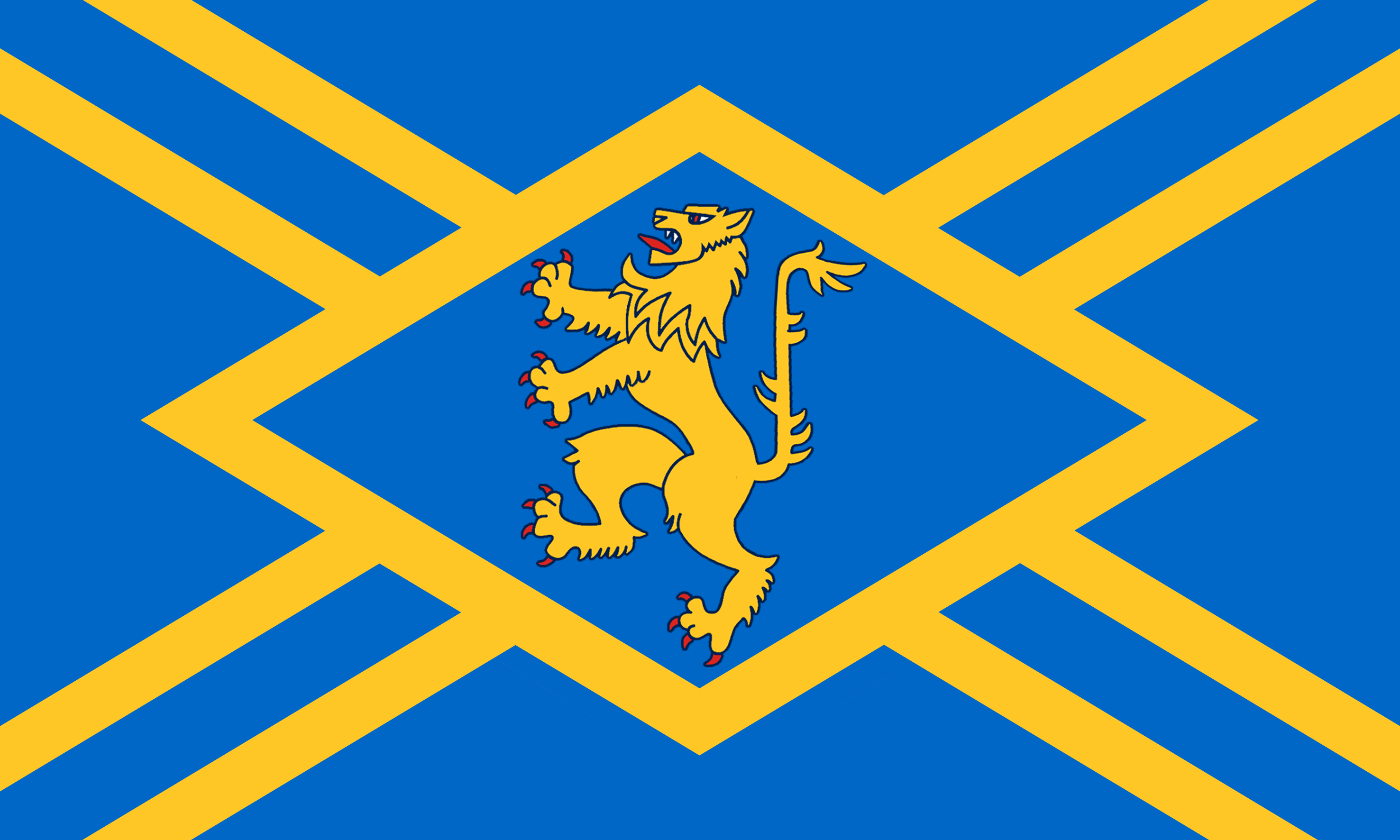
Following the end of the Roman occupation, Lothian was populated by Brythonic-speaking Ancient Britons and formed part of the kingdom of the Gododdin. In the 7th century, all of the Gododdin's territory fell to the Angles, with Lothian becoming part of the kingdom of Bernicia which later united into the Kingdom of Northumbria. Lothian came under the control of the Scottish monarchy in the 10th century. This county emerges early in history; the early 12th century Charters of that great reformer King David I refer to grants in Hadintunschira (and variant spellings), and it appears to have been a prosperous and important shire. Haddingtonshire was heavily involved in several mediæval and early modern conflicts. Dunbar Castle, Tantallon Castle and Dirleton Castle date from this period. In the 12th and 13th centuries, the Palace of Haddington was one of the seats of the Kings of Scotland. The palace and town were burned in 1216, by an English army under the command of King John of England. In 1296, the Battle of Dunbar was a decisive victory for the forces of Edward I of England against the forces of John Balliol. East Lothian was also the site of conflict during the Rough Wooing, with Dunbar Castle burnt in 1548. During the War of the Three Kingdoms, another Battle of Dunbar took place in 1650 between Scottish Covenanter forces and the Parliamentary forces under Cromwell. The Battle of Prestonpans was the first significant engagement of the Jacobite rising of 1745. Jacobite forces led Charles Edward Stuart defeated a government army under Sir John Cope in a battle that lasted only 30 minutes. The East Lothian flag was developed in 2018. It comprises a saltire design on blue, reflecting the local birthplace of the national flag, with a cross in gold signifying the wealth of the county’s farmlands and reputation as the granary of Scotland. A lion rampant is a traditional emblem of the county. Blue stripes through the gold represent the rivers Esk and Tyne.