
 Menu
MenuSearch the Gazetteer
Are the results not as expected? Modify your search term or change the scope to refine your search.
Results for a place that ends with ...
t
Dorset, England
 Dorset is a maritime county on the south coast of England, containing an enormous variety of landscapes. Poole owes its prosperity to Poole Harbour, a vast and deep natural harbour. To its south is the broad peninsula of the Isle of Purbeck, upon which stands the noble ruin of Corfe Castle. Swanage is a popular seaside resort. The entire coast, consisting of Triassic, Jurassic and Cretaceous cliffs, is a World Heritage Site. South of the resort of Weymouth is the Isle of Portland, connected to the mainland by the mighty Chesil Beach. At the far west of the county is Lyme Regis, "The Pearl of Dorset". Dorchester, the historic county town, lies north of Weymouth. Thomas Hardy was born in nearby Higher Brockhampton. In the county's centre are the Dorset Downs, on them the antiquities Maiden Castle and the Cerne Abbas Giant. To the north-east, Cranborne Chase has many Neolithic and Bronze Age monuments. Shaftesbury Abbey was founded by Alfred in 888. At the north of the county is the Blackmore Vale and the Saxon town of Gillingham.
Portrait of Dorset.
Place Type: Historic County
Lat, Long: 50.865347,-2.34794
Grid Reference: ST 7561 0737
Country: England
GBPN ID: 305821
GGA Code: C01000028
Entry Type: Main listing (P)
URL: https://gazetteer.org.uk/place/Dorset
 Explore Dorset on Wikishire
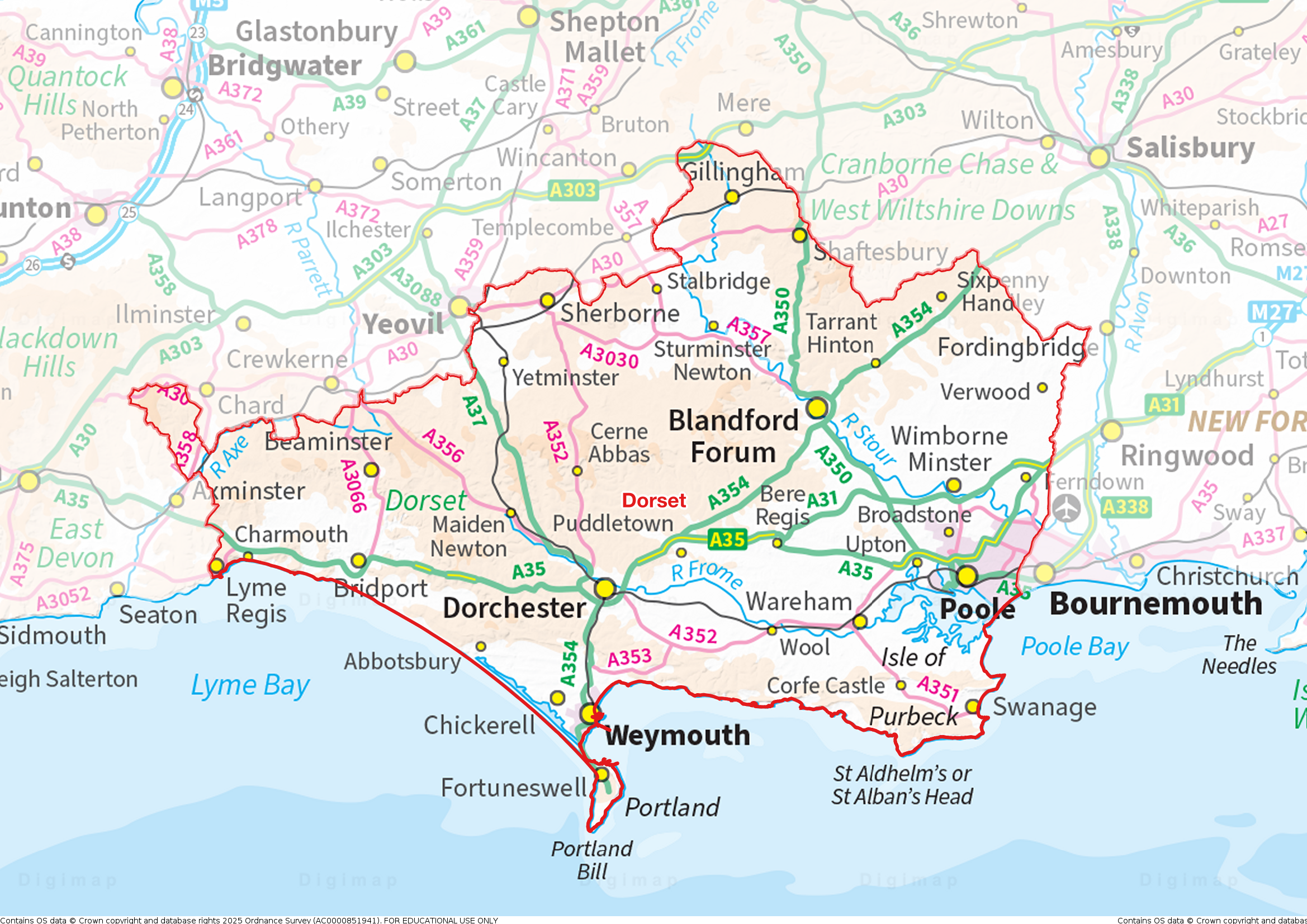
Poole, in the south-east of the county, is both a working port and a tourist resort. The historic port of Poole lies in what is now called the Old Town on the headland at the eastern entrance to Holes Bay. Since the 19th century a conurbation has developed around the town which now encompasses the former villages of Upton and Harmworthy west of Holes Bay; and Stanley Green, Waterloo and Longfleet east of the bay. The urban area spreads north to Canford Heath and Broadstone. To the east the conurbation includes Parkstone, Branksome, Talbot Village and has become contiguous with the urban area around Bournemouth in Hampshire.

Poole from Holes Bay
Several other towns lie just outside the Poole conurbation. To the north is Wimborne Minster with its Saxon church and many 15th-, 16th- and 17th-century buildings. The nearby 17th-century country house of Kingston Lacy (NT) is a majestic Italian Palazzo set in thousands of acres of gardens and pastures. North-east of Poole, along the Hampshire border, are the towns of Ferndown and Verwood.

Kingston Lacy
Poole owes its position and prosperity to Poole Harbour, a vast and deep natural harbour. Brownsea Island (NT) is a nature reserve and the birthplace of the Scouting movement. The affluent Sandbanks peninsula lies at the eastern entry to the Harbour. From here to Hengistbury Head in Hampshire stretches Poole Bay. The Bay has steep sandstone cliffs and several 'chines' that allow easy access to its long sandy beach. The border with Hampshire lies between Branksome Chine and Alum Chine.
.jpg)
Red squirrel on Brownsea Island
Wareham is an historic market town at the western end of Poole Harbour. West of Wareham is the isolated cottage of Clouds Hill (NT), home to T.E. Lawrence in the 1920s and 1930s. South of Poole Harbour is the broad peninsula known as the Isle of Purbeck. At its centre stands the noble ruin of Corfe Castle (NT). Built by the Conqueror, standing atop its hill, Corfe Castle is one of the classic images of a mediæval castle. Swanage was originally a small port and fishing village and later a wealthy seaside resort. Today tourism still flourishes.

Corfe castle
From Old Harry Rocks on the Isle of Purbeck, the entire Dorset coast is in the UNESCO World Heritage Site known as the "Jurassic Coast", one of the greatest natural wonders of Britain. The Jurassic Coast consists of Triassic, Jurassic and Cretaceous cliffs, spanning the Mesozoic Era, documenting 180 million years of geological history. The name "Jurassic Coast" refers to the wealth of dinosaur fossils found here. It was here that Mary Anning found some of the earliest of the great dinosaurs and thus founded the science of palaeontology. The coast is also famous for its spectacular beauty. Lulworth Cove is a delightful curve bitten out of the cliffs. Lulworth Castle is an early 17th century hunting lodge. Close by is the famous Durdle Door.

Lulworth Cove
Half way along Dorset's coast, on a sheltered bay at the mouth of the River Wey, is the resort town of Weymouth. To its south is the Isle of Portland. Portland Harbour, one of the largest man-made harbours in the world, was formed by the building of stone breakwaters between 1848 and 1905. Portland stone is a limestone famous for its use in British and world architecture including St Paul's Cathedral. Portland is connected to the mainland by the mighty Chesil Beach, a shingle bank 18 miles long stretching out in a smooth line from Portland to Bridport's harbour at West Bay. Behind the beach is the Fleet, a shallow tidal lagoon.

Chesil Beach from Portland
Since the Middle Ages Bridport has been associated with the production of rope and nets. Many buildings in Bridport date from the 18th century. To the west rises the Golden Cap (NT) (627ft), the highest point on the south coast of England and visible for tens of miles along the coastline. The charming village of Charmouth lies to its west.
At the far west of the county is the pretty coastal town of Lyme Regis, "The Perl of Dorset". One of the most famous sights of the town is the harbour wall, "The Cobb", which features in Jane Austen's novel Persuasion and in the book and film of The French Lieutenant's Woman, whose author John Fowles lived in the town and wrote most of his major works here.

Lyme Regis harbour
Dorchester, the county town, lies midway between its eastern and western extents and a few miles inland, separated from the coastal region by the South Dorset Ridgeway. It was the home of Thomas Hardy, whose famous Wessex novels were based in and around his familiar Dorset home, and in which Dorchester's fictional counterpart is "Casterbridge". Max Gate (NT) was designed by Hardy himself and his home from 1885 until his death in 1928. In the village of Higher Brockhampton, north-east of the town, is Thomas Hardy's Cottage (NT) where he was born in 1840 and his home until he was aged 34. Wolfeton House is an early Tudor and Elizabethan manor house amongst the water-meadows north-west of Dorchester.

Thomas Hardy's Cottage
The Dorset Downs are an area of chalk downland in the centre of Dorset, north and west of Dorchester. On the Downs are two of Britain's most famous historic monuments. Maiden Castle is the largest Ion Age hill fort in Britain. Its great banks and ditches scored deep into the hill are an impressive testament to their age and a source of wonder and inspiration to all who visit it. The Cerne Abbas Giant is a hill figure fully 180 feet high, depicting a standing nude male figure with a prominent membrum virile and wielding a large club in its right hand. It is often thought of as an ancient construction, though the earliest mention of it dates to the late 17th century. The village of Cerne Abbas contains the remains of Cerne Abbey, founded in 987. St Augustine's Well is located in a peaceful area next to the burial ground of the Abbey.

Maiden Castle ramparts
East of the Dorset Downs, separated from them by the River Stour, is the chalk plateau of Cranborne Chase. The Chase has many Neolithic and Bronze Age monuments, including the henge monuments at Knowlton and the remains of a number of Iron Age settlements on the downs, most notably the hill fort at Badbury Rings. The town of Shaftesbury lies at 705ft on the edge of the Chase. Here are the ruins of Shaftesbury Abbey, founded by King Alfred in 888. Adjacent to the abbey site is Gold Hill. The view from the top of the steep cobbled street has been called "one of the most romantic sights in England".

Gold Hill, Shaftesbury
To the north of the scarps of the Dorset Downs and Cranborne Chase is the Blackmore Vale. The east of the Vale is formed by the River Stour, the west by its tributary the River Lydden. The Stour enters Dorset at its most northerly point and flows down to Gillingham. There is a Stone Age barrow in the town, and evidence of Roman settlement: however the town was established by the Saxons. The church of St Mary the Virgin has a Saxon cross shaft dating from the 9th century. Constable's painting of the old town bridge is in the Tate Gallery.
South of Gillingham, the Stour meanders across the Vale to Sturminster Newton. The town is at the centre of a large dairy agriculture region. The poet and polymath William Barnes was born in nearby Bagber. He wrote over 800 poems, some in Dorset dialect, amongst a wealth of other work. The Stour leaves the Blackmore Vale at Blandford Forum, a town sandwiched between the Dorset Downs and Cranborne Chase. The town is noted for its fine Georgian architecture, having been rebuilt in the style after a disastrous fire in the 18th century.
The market town of Sherborne stands on the River Yeo at the edge of the Blackmore Vale. Sherborne Abbey is of ancient foundation. In the Anglo-Saxon period it was the site of a monastic church which was a diocesan cathedral (705–1075). It was a Benedictine abbey church from 998 until the Dissolution since when it has been the town's parish church. Sherborne Old Castle was built in the 12th century by Roger de Caen, Chancellor of England. The palace was destroyed in 1645 by General Fairfax. In 1594 Sir Walter Raleigh built an Elizabethan mansion in the grounds of the old palace, today known as Sherborne Castle.

Sherborne Old Castle
The town of Beaminster sits at the top of the valley of the River Birt, which flows south to Birdport and the sea. The towns was previously a centre of manufacture of linen and woollens.
The Marshwood Vale is a low-lying, bowl-shaped valley in the west the county. It is drained by the River Char, which flows south-west to its mouth at Charmouth. The landscape of the Vale consists of narrow lanes winding between farms that lie amongst small fields, old hedgerows, copses and ancient semi-natural woods. The vale is almost wholly surrounded by hills, including Lewesdon Hill, Dorset's county top. Atop of Pilsdon Pen and Lambert's Castle Hill are Iron Age hill forts. The Vale has escaped large-scale agricultural intensification, leading to a landscape that still contains a wealth of wildlife.

Pilsdon Pen
In the far west of the county the valley of the River Kit forms a salient of Dorset between Somerset and Devon. The Kit rises near Wambrook and flows down passed Chardstock, being crossed by the Fosse Way south of Tytherleigh before joining the Axe.
Dorset's high chalk hills have provided a location for defensive settlements for millennia. There are Neolithic and Bronze Age burial mounds on almost every chalk hill in the county along with a number of Iron Age hill forts, including Maiden Castle - the most famous of them all. The Romans landed in Dorset at Poole Harbour and the Fleet and quickly conquered the area. Dorset has many notable Roman artefacts, particularly around the Roman town of Dorchester. From about AD 400 to 650, the future Dorset was an independent British kingdom. By the end of the 7th century, Dorset had become part of the Saxon kingdom of Wessex, with the first record of Dorset ('Doseteschire') being in 841. The Saxons established a diocese at Sherborne and Dorset was made a shire. The Domesday Book documents many villages corresponding to modern towns and villages and there have been few changes to the parishes since.
.jpg)
Dorset Flag flying in West Lulworth
The flag of Dorset (also known as the Dorset Cross, and Saint Wite's Cross) comprises a white cross with a red border on a gold background. The Dorset militia and regiment used the colours gold, red and green. The gold represents several things related to Dorset: Wessex, Dorset's agriculture, Dorset's sandy beaches, Golden Cap and Gold Hill. The flag also recognises St Wite, a female Dorset saint who is buried at Whitchurch Canonicorum. Dorset Day is celebrated on 1st June – the feast day of Saint Wite.
Kent, England
 Kent is a maritime county at the south-easternmost point of Great Britain. Kent was a British kingdom before the Romans came and after them it became a Jutish kingdom. The county is known as the “Garden of England” for the richness of its arable farming. The north-west of Kent, from Lewisham and Greenwich out to Bromley, is part of the metropolitan conurbation. Rural Kent holds a great variety of landscape, from the North Downs, to the delightful Weald, down to the fertile solitudes of Romney, Denge, and Walland Marshes, and the Isle of Thanet in the north-east. The county's main towns include Maidstone, Tonbridge, Ashford and Royal Tunbridge Wells. Rochester, an ancient cathedral city, is at the lowest bridging point of the River Medway. The City of Canterbury is where St Augustine established himself in AD 597, and is the seat of the Archbishop of Canterbury. The famous White Cliffs look out over the Straits of Dover.
Portrait of Kent.
Place Type: Historic County
Lat, Long: 51.201274,0.543852
Grid Reference: TQ 7781 4774
Country: England
GBPN ID: 305828
GGA Code: C01000045
Entry Type: Main listing (P)
URL: https://gazetteer.org.uk/place/Kent
Explore Kent on Wikishire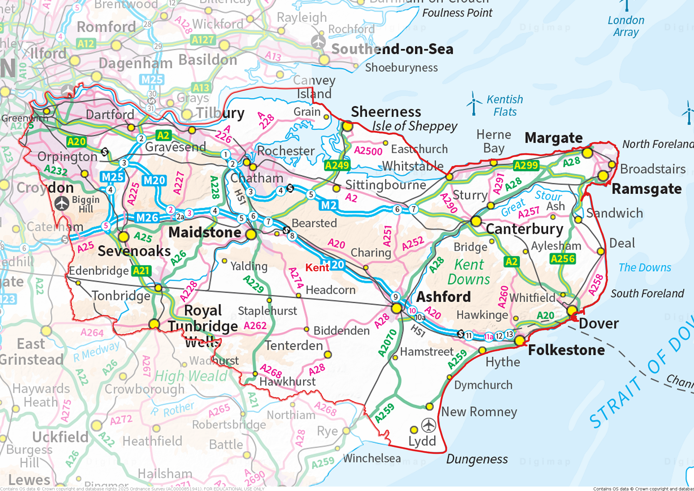
Kent's southern border with Sussex runs through the deeply ridged and folded countryside of the High Weald. The high land and ridges is formed from sandstone. The lower land between ridges is the result of softer clays which have been more easily eroded. The result is a mediæval landscape of wooded, rolling hills studded with sandstone outcrops; small, irregular-shaped fields; scattered farmsteads; and ancient routeways.

Chiddingstone
On the High Weald, in the west of Kent, stands the 13th-century Hever Castle, the childhood home of Anne Boleyn and later owned by Anne of Cleves. The nearby village of Chiddingstone is described by the National Trust as " the most perfect surviving example of a Tudor village in the county". Chiddingstone Castle dates from the early 19th century with elements of earlier buildings. To the east is the Georgian spa town of Royal Tunbridge Wells. The border with Sussex is marked by a flagstone outside the church of King Charles the Martyr. Cranbrook is an ancient market town, once a centre of the Wealden cloth industry. Union Mill (1814) is a working windmill. Nearby Sissinghurst Castle is now a romantic ruin. Around it is the famous Sissinghurst Castle Garden (NT), created in the 1930s by Vita Sackville-West and her husband Harold Nicolson. The former port town of Tenterden stands on the eastern edge of the High Weald overlooking the valley of the River Rother.

Sissinghurst Castle and gardens
The Low Weald is a broad, low-lying clay vale which largely wraps around the northern and western edges of the High Weald. It is predominantly agricultural, supporting mainly pastoral farming owing to heavy clay soils. It has many densely wooded areas. In the west of the county, on the River Eden, is Edenbridge, once a centre of the Wealden iron industry. The town has many mediæval timber buildings. The Medway rises on the High Weald and flows through the biggest town in the Low Weald, Tonbridge. Tonbridge stands on a spur of higher land where the marshy River Medway could be more easily forded. Tonbridge Castle was built here in the 11th century by Richard Fitz Gilbert. Tonbridge School was established in 1552. Paddock Wood developed as a centre of the local hops industry and remains one. The village of Hamstreet lies at the eastern end of the Low Weald, with the flat landscape of Romney Marsh beyond.
Wrapping around the Low Weald is the Greensand Ridge, an extensive, prominent mixed greensand/sandstone escarpment. Several of the major towns of Kent lie along the ridge. It also forms a transport corridor with major road and rail routes running along it. The ridge enters Kent around the town of Westerham. South of the town is Chartwell Manor (NT), Churchill's home from 1922 until his death. Sevenoaks was first recorded in the 13th century. It developed around Knole House (NT), built in the 15th century as a palace for the Archbishop of Canterbury. The house sits in Knole Park (NT), a 1,000-acre deer park. Sevenoaks School, founded in 1432, is the oldest secular school in England. To the south, the mediæval moated manor house of Ightham Mote (NT) was described by Pevsner as "the most complete small mediæval manor house in the country".

Chartwell
Maidstone lies where the Medway cuts through the Greensand Ridge. Historically, the river carried much of the town's trade as the centre of agricultural Kent. Leeds Castle was a favourite residence of Edward I. The present building dates mostly from the 19th century and is built on islands in a lake formed by the River Len. Ashford, on the River Great Stour, has become a key transport hub. Its agricultural market is one of the most important in the county. At its south-eastern extreme, the Greensand Ridge forms a notable scarp, formerly a sea cliff, on which lies the village of Lympne, overlooking the Romney Marsh. The Port Lympne Wild Animal Park incorporates the early-20th-century Port Lympne Mansion and its landscaped gardens designed by architect Sir Herbert Baker.

Romney Marsh
The Greensand Ridge meets the sea in a short coastal stretch which extends from Folkestone to Hythe. From the beginning of the railway age, Folkestone developed from a small fishing community to be both a passenger port and as a high-class seaside resort. Hythe is beside a broad bay, although silting removed its harbour hundreds of years ago. The town has mediæval and Georgian buildings, an Anglo-Saxon / Norman church and seafront promenade.
Below the Weald, in the far south-east of Kent, lies Romney Marsh, a sparsely populated wetland area. Criss-crossed with numerous waterways, the Marsh has over time sustained a gradual level of reclamation, both through natural causes and by human intervention. It covers about 100 square miles. In previous centuries, its isolation made it a notorious haunt of smugglers. The Marsh is famous for its long-wool "Romney" sheep. New Romney grew as a sea port, with the harbour adjacent to the church, but is now more than a mile from the sea.
To the north of the Greensand Ridge, the North Downs stretch across Kent, from south of Biggin Hill in the west to the White Cliffs of Dover in the east. The Kent section is also know as the Kent Downs. The county top, Betsom's Hill, lies on the Kent Downs, close to the Surrey border. The Kent Downs have a steep south-facing scarp slope and a more gentle north-facing dip slope. Their southern boundary is defined by the low-lying Vale of Holmesdale at the foot of the escarpment, separating it from the Greensand Ridge. The ridge of the North Downs is intersected by the valleys of a series of rivers: the Darent, Medway and Stour which drain much of the Weald. Along the Darent valley is the village of Lullingstone. Lullingstone Roman Villa contains a Romano-Christian chapel, displaying some of the earliest evidence of Christianity in Britain. Lullingstone Castle dates from 1497. The surrounding deer park is renowned for its collection of ancient trees.

The White Cliffs of Dover
The White Cliffs of Dover spread for about eight miles along the Kentish coast, with the ancient and modern port of Dover crammed into a gap in the cliffs. The cliff face, which reaches up to 350 feet, owes its striking façade to its composition of chalk accentuated by streaks of black flint. Dover has since ancient days been the major conduit for traffic across the narrow seas betwixt Britain and Europe. The Roman's named the town Dubris. Above the town, on the Eastern Heights, is Dover Castle, founded in the 11th century and described as the "Key to England" due to its defensive significance throughout history. The Pharos Roman lighthouse still stands in the castle grounds. On the Western Heights are a series of 18th- and 19th-century forts, strong points and ditches, including The Citadel and Drop Redoubt. The area is now a nature reserve.

Pharos Roman lighthouse and St Mary in Castro church, Dover
Between the North Downs and the Thames Estuary is the North Kent Plain. The area is essentially open, low and gently undulating land. It is a very productive arable land, with traditional orchards, soft fruits and other horticultural crops. At its south-east, north of Dover, is the quiet seaside resort of Deal. Its finest building is Deal Castle, commissioned by King Henry VIII and designed with an attractive rose floor plan. Once a major port, Sandwich is now two miles from the sea, its historic centre preserved but its historic role lost as the sea has retreated.

Deal Castle
The Isle of Thanet, long since connected to the mainland, lies in the north-east tip of Kent. Long before Ramsgate became a great seaside town in the 19th century it was a busy port and remains so. Broadstairs is known as the "jewel in Thanet's crown". Margate has been a leading seaside resort for at least 250 years. West along the Thames Estuary is Herne Bay, a seaside resort which rose to prominence in the early 19th century after the building of the pleasure pier and promenade. Whitstable is famous for its oysters, which have been collected in the area since at least Roman times.

Broadstairs
Five miles south of Whitstable, on the River Stour, is the historic cathedral city of Canterbury. Canterbury stood before the Romans came in the 1st century AD, and since then it has been a Roman town, then the capital of the Kingdom of Kent, a major mediæval town and now a modest provincial city. After Kent accepted Christianity in 597, St Augustine founded an episcopal see in the city and became the first Archbishop of Canterbury. The cathedral was completely rebuilt from 1070 to 1077 and developed in ensuing centuries. In 1170, Thomas Becket, then Archbishop, was murdered in Canterbury Cathedral and this led to the cathedral becoming a popular place of pilgrimage. Many historical structures remain in the city, including a city wall founded in Roman times, the ruins of St Augustine's Abbey and a Norman castle. The 6th-century St Martin's Church is the oldest church in Britain still in use as a church. It was originally the private chapel of Queen Bertha of Kent, Æthelberht's Christian Frankish Queen.

St Martin's Church, Canterbury
Faversham is a market town which lies next to the Swale, the strip of sea separating mainland Kent from the Isle of Sheppey. There has been a settlement at Faversham since pre-Roman times, next to the ancient sea port on Faversham Creek. The town was favoured by King Stephen who established Faversham Abbey. Faversham Market dates back over 900 years, the oldest street market in Kent. Shepherd Neame Brewery, founded in 1698, claims to be the oldest in Britain. Sittingbourne, in a creek off the Swale, developed as a port from which Kentish produce was transported to the London markets. It had a long history of paper manufacture, growing to become the the largest producer of newsprint in the world. The last paper mill closed in 2006.
The Isle of Sheppey lies off the Coast opposite Sittingbourne. The island's main towns are Sheerness and Minster. The island, like much of north Kent, comprises London Clay and is a plentiful source of fossils. The ground is mainly low-lying, but at The Mount near Minster rises to 250 feet above sea level.

Warden, view towards Leysdown-on-Sea, Isle of Sheppey
Rochester is at the lowest bridging point of the River Medway. The city is marked by two grand edifices; Rochester Cathedral and Rochester Castle. A great deal of history is found in these streets; Romans, Anglo-Saxon, Mediæval and modern. Strood stands on the north-west bank of the River Medway, opposite to Rochester. Strood's history has been dominated by the river, the bridges and the road and rail links they carried. It is now a mainly residential suburb of Rochester, and a commuter town for London. Upnor Castle, an Elizabethan artillery fort, lies on the Medway north of the town.

Rochester Cathedral
In 1568 Queen Elizabeth I established the Royal Dockyard on the east bank of the Medway. Chatham, Brompton and Gillingham are all ancient settlements which grew around the dockyard and the 19th-century forts built to provide it with a defensive shield. The Dockyard closed in 1984, but the remaining major naval buildings are an attraction for a flourishing tourist industry. Rainham grew from a small village south of the Medway estuary to a residential town with the arrival of the railway in 1858.
The Hoo Peninsula separates the Medway and Thames estuaries. It is dominated by a line of sand and clay hills. Surrounding these are the North Kent Marshes, a major habitat for wetland birds. Cooling Castle is a 14th-century quadrangular castle built by the Cobham family to guard against French raids into the Thames Estuary. The strategic location of the Hoo peninsula has made it home to several power stations and oil refineries, especially at its farthest extent, on the Isle of Grain.

Gravesend Pier
The North Kent Marshes stretch east from Hoo along the Thames estuary to Gravesend. Because of its geographical position Gravesend has always had an important role to play in the history and communications of south-eastern Britain. The Pier is the world's oldest surviving cast iron pier, built in 1834. Windmill Hill offers extensive views across the Thames, and was a popular spot for Victorian visitors.
Dartford is situated in a valley through which the River Darent flows, and where the old road from London to Dover crossed: hence the name, from Darent ford. Dartford became a market town in the Middle Ages. Today it is principally a commuter town. During the Middle Ages Dartford was an important waypoint for pilgrims and travellers on the way to Canterbury and Europe, and various religious orders established themselves in the area. The Knights Hospitallers of the Order of Saint John of Jerusalem established a commandery at Sutton-on-Hone in 1199. The remains of its 13th-century chapel forms St John's Jerusalem (NT).
The north-west of Kent lies in the metropolitan conurbation, containing a great variety of townscapes. Orpington stands at the edge of the conurbation. The Priory is a 13th-century mediæval hall house, surrounded by Italianate and Arts & Crafts style formal gardens. Bromley was a market town which grew with the arrival of the railway. Its famous son H.G. Wells was born on the High Street in 1866. Sidcup is a fashionable suburb, with large Victorian and Edwardian properties alongside typical 1930s suburbia. Its many parks and open spaces hint at the great estates and large homes which once stood in the area.

The Priory, Orpington
Into the 19th century, Bexleyheath was an area of scrub-land bordering Watling Street. In 1766 Sir John Boyd had the Palladian mansion Danson House built. The surrounded parkland now forms Danson Park. Red House is a significant Arts and Crafts building, co-designed in 1859 by the architect Philip Webb and the designer William Morris. It served as a family home for Morris.

Red House, Bexleyheath
Woolwich is a river crossing point, with the Woolwich Ferry and the Woolwich foot tunnels. Woolwich was a small Kent village which grew to become a leading military and industrial town. It was home to the Woolwich Dockyard, the Royal Arsenal, the Royal Military Academy and the Royal Horse Artillery. Arsenal Football Club was founded in 1886 by workers at the Royal Arsenal – the club were initially known as Dial Square, then Royal Arsenal and then became Woolwich Arsenal in 1891.
The junction of Rock Hill and Sydenham Hill Road in Upper Sydenham forms the westernmost point of Kent. The border with Surrey runs north up Sydenham Hill Road with views out across metropolitan Surrey. Beckenham was, until the coming of the railway in 1857, a small village, with most of its land being rural and private parkland. John Barwell Cator and his family began the leasing and selling of land for the building of villas which led to a rapid increase in population. Lewisham was a small village until the development of passenger railways in the 19th century.

The County Ground, Beckenham
In the north-west of Kent, on the Thames, lies the world famous town of Greenwich. Its rise to fame began when the Palace of Placentia was built here by Humphrey, Duke of Gloucester in 1443. The palace was the birthplace of many Tudors, including Henry VIII and Elizabeth I. The Old Royal Naval College is the architectural centrepiece of the Maritime Greenwich UNESCO World Heritage Site. The buildings, originally constructed to serve as the Royal Hospital for Seamen, was designed by Christopher Wren and completed in 1712. The Cutty Sark and Gipsy Moth IV are sited on the river front. The National Maritime Museum is housed in buildings forming another symmetrical group and grand arcade around the Queen's House, designed by Inigo Jones. Greenwich Park includes the former Royal Observatory, the crosshairs of whose telescope define the prime meridian of the world.

Royal Observatory, Greenwich
In 1066 the Normans landed nearby in Sussex. The men of Kent according to legend raised the fyrd to oppose William independently and made a separate peace without clash of arms. This legend is the origin of the county motto Invicta, meaning "unconquered". Kent played a major role in several of England's most notable rebellions, including the Peasants' Revolt of 1381, led by Wat Tyler, Jack Cade's Kent rebellion of 1450, and Wyatt's Rebellion of 1554 against Queen Mary.
The Kent Flag features the white horse of Kent (supposedly based on that of Horsa, the Jute) on a red background. It is sometimes referred to as the Invicta Flag. Kent Day is celebrated on 26th May, the feast day of St Augustine.
Somerset, England
 Somerset is a maritime county in the West Country. The county is mainly agricultural and is traditionally associated with cider production. The Somerset coast includes the resort towns of Minehead, Watchet, Burnham-on-Sea, Weston-super-Mare and Clevedon. In the north-east of the county, on the River Avon, is Bath, built by the Romans on the hot springs though equally famous for its Georgian splendour. Downstream is the mediæval market town of Keynsham and then Bristol, the southern part of which, including Bedminster, Knowle and Whitchurch, lies in Somerset. South of Bristol run the Mendip Hills, including the spectacular Cheddar Gorge. In the heart of the county are the Somerset Levels, an ancient flat landscape above which rises Glastonbury Tor. East of the levels lies the cathedral city of Wells. South of the levels, Bridgwater is famous for its Guy Fawkes illuminated carnival. The south of Somerset is a quiet rural area, the few small towns including Somerton, Wincanton, Yeovil and Chard. Taunton has over 1,000 years of religious and military history. To its west lies Exmoor, a high sandstone moor and a national park.
Portrait of Somerset
Place Type: Historic County
Lat, Long: 51.143314,-2.68334
Grid Reference: ST 5229 3845
Country: England
GBPN ID: 305836
GGA Code: C01000078
Entry Type: Main listing (P)
URL: https://gazetteer.org.uk/place/Somerset
Explore Somerset on Wikishire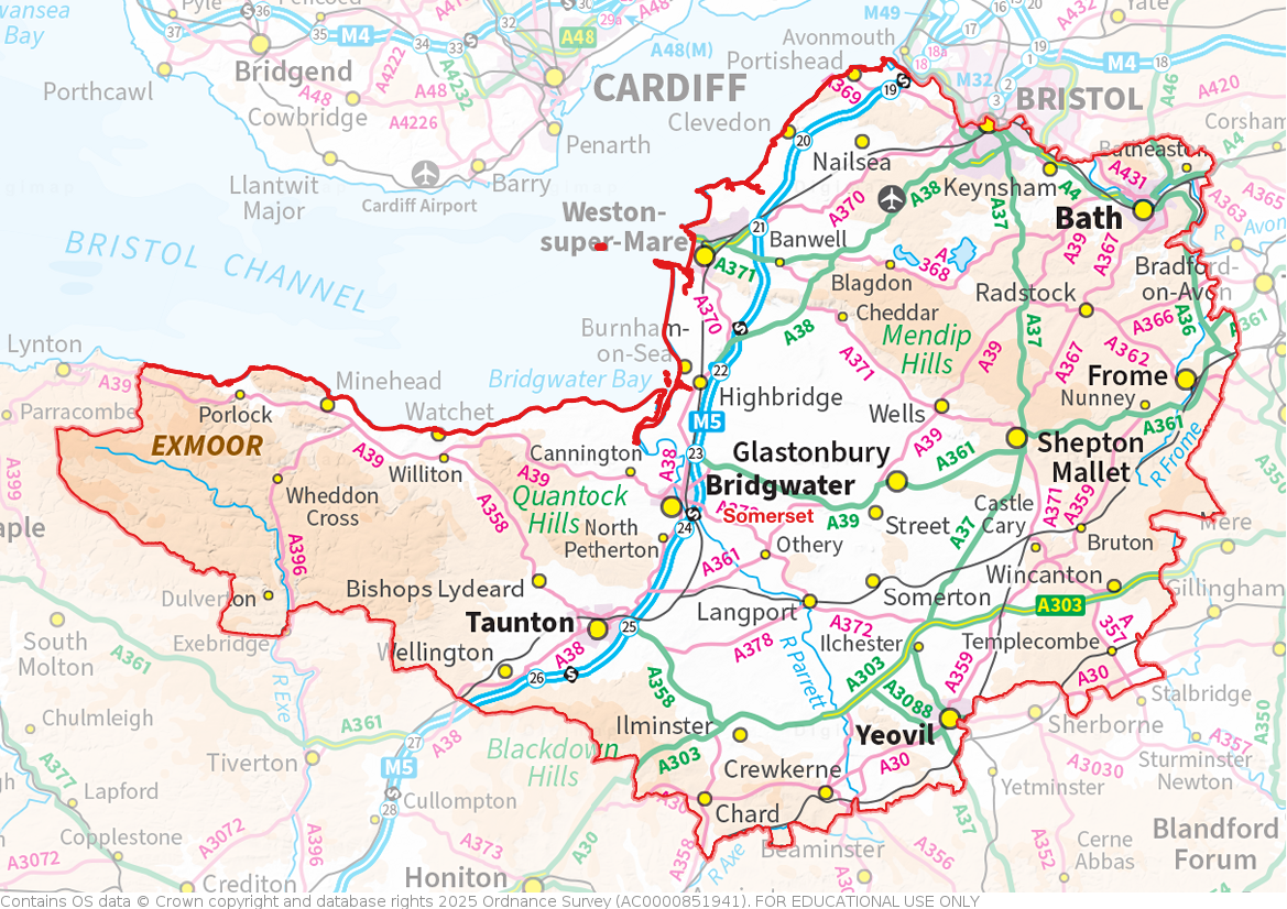
The Somerset coast stretches for 40 miles of the Bristol Channel from the Avon to Exmoor and includes a string of resort towns. Minehead was once a busy commercial port that reinvented itself, from the Edwardian era onwards, as a port for pleasure steamers and as a holiday resort. Butlins Minehead opened in 1962 and is one of the last of the original camps still open. Watchet is a quiet harbour town. Samuel Taylor Coleridge's poem The Rime of the Ancient Mariner was written whilst travelling through Watchet and the surrounding area. Burnham-on-Sea claims that its concrete pier, built in 1911-1914, is the shortest pier in Britain. The coming of the railways to Weston-super-Mare in the 19th century changed it from a small village to the major resort it has become. The Grand Pier remains a major attraction. Clevedon's Pier, opened in 1869, is one of the earliest examples of a Victorian pier still in existence. Clevedon Court (NT) is a 14th-century manor house. Portishead was a fishing port that grew to be a major dockyard and industrial site. Now it is primarily a commuter town for Bristol.

The harbour and marina at Watchet
In the north of the county, on the River Avon, lies the jewel that is Bath, a fashionable retreat for Georgian gentry and now a destination for anyone. It is home to the only natural hot springs in Britain, the pungent water pouring forth at a great rate from hidden wells beneath. On this the Romans built their town and others followed. The result of Regency fashion and local stone is one of the most remarkable cities in the kingdom.

The Great Bath in the Roman Baths complex at Bath
Downstream is the mediæval market town of Keynsham and then Bristol, one of the great cities of the realm, split along the old course of the Avon between Somerset and Gloucestershire. Ashton Gate, Bedminster, Knowle, Windmill Hill, Totterdown and Whitchurch lie on the Somerset side of the city. Bristol City Football Club traditionally draws its support from this part of the city and from Somerset generally.

Totterdown
To the south-west of Bristol is Nailsea, a town which grew on coal mining and glass manufacture but is now primarily a commuter town. North of the town is Tyntesfield (NT), a Victorian Gothic Revival house.

Tyntesfield
South of Bristol run the Mendip Hills. The caves of the Mendips were settled during the Palaeolithic period onward and contain extensive archaeological sites such as those at the spectacular Cheddar Gorge. The Wookey Hole Caves are a show cave and tourist attraction in the village of Wookey Hole on the southern edge of the Mendip Hills. Axbridge lies on the River Axe, near the southern edge of the Mendips. King John's Hunting Lodge (NT) is a wool-merchant's house of around 1460. Frome is built on uneven ground at the eastern end of the Mendips. The town first grew due to the wool and cloth industry; it later diversified into metal-working and printing. It retains a large number of listed buildings. Nunney Castle (EH) is a 14th-century castle to the south-west of Frome. The moated castle's architectural style was possibly influenced by the design of French castles.

Nunney Castle
In the heart of the county are the Somerset Levels, a remarkable flat land reaching in from the Bristol Channel, divided in two by the low range of the Polden Hills. The land of the Levels is at or around sea level and in former days was regularly flooded (and some have suggested that Somerset's gets its name from the reappearance of the land in the summer). The Levels are criss-crossed with "rhines", drainage ditches, and that many of the villages' names end in -ey, "-island" tells of life before the Somerset Levels were drained.

Glastonbury Tor
One of the most dramatic features of the Levels is Glastonbury Tor, a lone hill rising steeply from the Levels, atop which stands a ruined mediæval chapel. At the foot of the Tor are the ruins of Glastonbury Abbey, around which the town grew from the Early Middle Ages to the Reformation. In 1191 the monks of the abbey alleged they had discovered the tomb of King Arthur and Queen Guinevere in the abbey's cemetery. Glastonbury has been associated with Arthurian legend ever since. Another popular legend is that the abbey was founded immediately after the Crucifixion by Joseph of Arimathea. The legend has Joseph planting his staff into the ground, which it flowered miraculously into the Glastonbury Thorn. More historically, King Alfred of Wessex hid in the Levels at Athelney, before bursting forth and defeating the Danes to restore England.

Athelney with King Alfred's Monument
East of the levels lies Wells, home of Bishop of Bath and Wells. It is a small market town with a large cathedral of unique architecture, and a castle. The Bishop's Palace, adjacent to the cathedral, dates to the 13th century. The gardens include St Andrew's Spring from which the city takes its name. The spring supplies St Andrew's Well from which water flows into the moat. East of Wells is Shepton Mallet which lies on the River Sheppey and the Fosse Way. The mediæval wool trade gave way to industries such as brewing in the 18th century. The town remains noted for cider production. HM Prison Shepton Mallet was England's oldest prison still in use prior to its closure in 2013, having opened in 1610.
South of the levels, the market town of Bridgwater is famous for its annual Guy Fawkes illuminated carnival, a spectacular celebration also held in the other towns of Somerset. The Quantock Hills, west of Bridgwater, were England's first designated Area of Outstanding Natural Beauty.

Bridgwater Carnival
The south and south-east of Somerset is a quiet rural area. Somerton stands in the centre of this area. The town has held a weekly market since the Middle Ages, and the main square with its market cross is today an attractive location for visitors. Stembridge Tower Mill (NT) in High Ham, north-west of Somerton, is the last remaining thatched windmill in Britain. Wincanton, in the south-east close to the Dorset border, is home to Wincanton Racecourse, opened in 1966. The nearby market town of Castle Cary lies on the River Cary. Bruton was the site of an Augustinian priory from which only a wall remains. The town is also well-known from the English folk song, The Bramble Briar. Yeovil lis further south, standing hard by the River Yeo, the border with Devon. Nearby is Montacute House, a late Elizabethan three-storey mansion. In the deep south of county are the quiet towns of Ilminster, Chard and Crewkerne.

Dunster Castel
Taunton, the county town, in the south-west has over 1,000 years of religious and military history, including a 10th-century monastery. Taunton Castle has origins in the Anglo Saxon period. The town also houses Somerset County Cricket Club's County Ground. Wellington, a small industrial town to the south-west of Taunton, gave its name to the title of the Dukes of Wellington. To the west of Taunton the county is almost entirely rural, apart from Minehead on the coast. Dunster Castle is a motte and bailey castle long since converted into a country house. The castle stands on the top of a steep hill called the Tor, and has been fortified since the late Anglo-Saxon period. In the far west of the county, running into Devon, is Exmoor, a high sandstone moor, which was designated as a national park in 1954. The highest point in Somerset is here: Dunkery Beacon standing at 1,703 feet.
,_Tarr_Steps_--_2013_--_4.jpg)
Tarr Steps, River Barle, Exmoor
There are numerous Iron Age hill forts in Somerset, some of which, like Cadbury Castle and Ham Hill, were later reoccupied in the Early Middle Ages. The Stanton Drew stone circles are believed to be Neolithic.

Stanton Drew
During the first two centuries of the Saxon conquest, Somerset was a borderland between the Saxons and the Britons. By the early eighth century though King Ine of Wessex had pushed the boundaries of the West Saxon kingdom far enough west to include all of Somerset. The name is first recorded in 1015 as 'Sumaersaeton'. After the Norman Conquest, the county was divided into 700 fiefs, and large areas were owned by the crown.
The county is mainly agricultural, with dairy farming, stock raising and market gardening being important. The county is traditionally associated with cider production, and the village of Cheddar, in the Mendip Hills, has given its name to the cheese that was first made there. Tourism is also important to county's economy. Manufacturing and engineering are significant in the county’s larger towns.
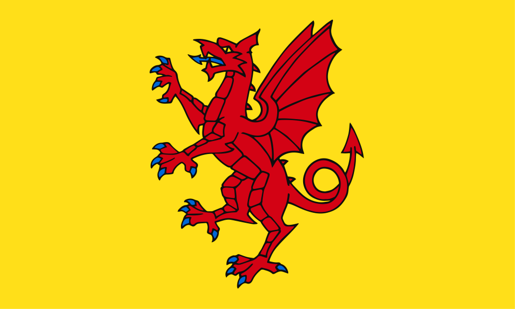
The Somerset Flag comprises a red dragon, the traditional emblem of Somerset, on a gold background. The red dragon is derived from the banners borne by Alfred the Great and his kinsmen during the era of the Viking Wars. Somerset Day is celebrated on May 11th, commemorating the gathering of his people by King Alfred to battle and defeat the Danes in May 878.

The Somerset Flag at Creech Castle