
 Menu
MenuSearch the Gazetteer
Are the results not as expected? Modify your search term or change the scope to refine your search.
Results for a place that exactly matches ...
Rutland
Rutland, England
 Rutland is an inland county, the smallest in England. Rutland's length north to south is 18 miles at its longest, and its breadth east to west 17 miles. The highest point of the county is at Flitteriss Park (a farm east of Cold Overton Park) at 646 feet. Rutland is almost entirely agricultural. The shire is marked by numerous pretty villages characterised by cottages of limestone and ironstone, with roofs thatched or of Collyweston stone slate.
Type: Historic County
Lat, Long: 52.673648,-0.648261
Grid Reference: SK914092
Country: England
 Explore Rutland on Wikishire
Rutland is a well watered place; the Eye Brook, the Chater, and the Gwash flowing through green vales between rolling hills. The south-eastern border is the Welland. The Gwash was dammed in the 1970s, flooding a huge area for a reservoir; Rutland Water. Although its construction was the subject of considerable opposition and involved the demolition of the hamlet of Nether Hambleton, Rutland Water today provides a major recreational resource to the county and is a wetland of international wildlife importance. Burley-on-the-Hill House is a 17th century mansion overlooking the northern shore of the reservoir. Nearby is Alstoe, the site of a possible small motte-and-bailey castle, and Barnsdale Gardens, developed by gardener and television presenter Geoff Hamilton.
.jpg)
Rutland Water with Burley-on-the-Hill House
The Vale of Catmose is an area of relatively low-lying land in the west of the county. Within it lies the county town, Oakham, a charming market town centred around a small square and market-cross. Oakham Castle, within the town, is a fortified manor house with an important 12th-century great hall and home of an extraordinary collection of presentation horseshoes. The Rutland County Museum is also in Oakham. At Whissendine, north-west of Oakham, is the Whissendine Windmill, built in 1809.

The Great Hall, Oakham Castle
Further south, around Uppingham, the ground rises into broken and picturesque scenery. Uppingham is a small market town, home of the public school, Uppingham School. Close by, at Castle Hill. are the earthwork remains of a mediæval motte and bailey castle. Lyddington Bede House (EH) is a part of a former palace of the Bishops of Lincoln, situated next to the church in the village of Lyddington.

Lyddington Bede House
Tolethope Hall is a country house in the parish of Little Casterton in the east of the county. Once a country seat for minor gentry, it is now the home of the Stamford Shakespeare Company and the grounds provide their famous open-air theatre, the Rutland Theatre.

Tolethorpe Hall
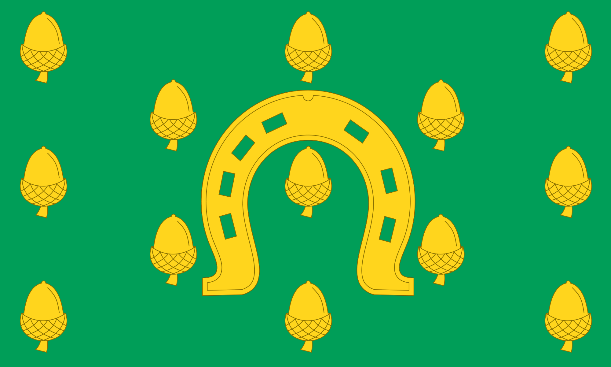
There are two large British Army barracks in the county. Kendrew Barracks lies in the north, close to Cottesmore, the county's largest village. St George's Barracks lie close to North Luffenham in the south.
Rutland was first mentioned as a separate county in 1159. The north-western part of the county of Rutland was recorded as Rutland, a detached part of Nottinghamshire, in the Domesday Book. The south-eastern part had been the wapentake of Wicelsea in Northamptonshire. In 1584 Uppingham School and Oakham School, two of the earliest public schools of England, were founded by Archdeacon Robert Johnson. Both of the original school buildings remain standing. The Rutland Flag comprises a golden horseshoe and a semy of acorns on green. The horseshoe has been the traditional emblem of the county since at least 1784. The horseshoe refers to a tradition where dignitaries travelling through the county are compelled to deliver a horseshoe to Castle Hall in the county town of Oakham. The acorns are in reference to Rutland’s small area.