
 Menu
MenuSearch the Gazetteer
Are the results not as expected? Modify your search term or change the scope to refine your search.
Results for a place that exactly matches ...
Kirkcudbrightshire
Kirkcudbrightshire, Scotland
 Kirkcudbrightshire is a maritime county on the north coast of the Solway Firth. It is sometimes known as the Stewartry of Kirkcudbright. With neighbouring Wigtownshire it forms the informal region of Galloway.
Type: Historic County
Lat, Long: 55.011234,-4.052654
Grid Reference: NX688704
Country: Scotland
 Explore Kirkcudbrightshire on Wikishire
The north-western part of the county is rugged, wild and desolate. Here are found Merrick, the county top and the group of the Rhinns of Kells. The Galloway Forest Park, established in 1947, covers around 300 square miles in the north and west of Kirkcudbrightshire, running up to the River Cree, the border with Wigtownshire. In the north-east of the county rises the majestic hill of Cairnsmore of Carsphairn (2,614 feet), and close to the Ayrshire border is the Windy Standard (2,290 feet).

Cairnsmore of Carsphairn
The southern section of the shire is mostly level or undulating, but characterised by picturesque scenery. The dales of Kirkcudbrightshire which sweep down to the sea are of a special beauty. The Urr Water cuts it way to the Solway below Dalbeattie, the Dee and Ken Water to Kirkcudbright, where the waters open out into the great inlet of Kirkcudbright Bay. The Cree Water further west is a boundary river opening into the broad bay of Wigtown.
The shore is generally bold and rocky, indented by numerous estuaries forming natural harbours, which however are of little use for commerce owing to the shallowness of the sea. Large stretches of sand are exposed in the Solway at low water and the rapid flow of the tide has often occasioned loss of life.
The main towns lie in the south of the county.
Gatehouse of Fleet takes its name from its location near the mouth of the Water of Fleet. The western approach to the town is dominated by the imposing 15th-century tower house Cardoness Castle. Near the town are fine beaches at Carrick and Sandgreen.

Cardoness Castle
Kirkcudbright, the county town, is a small town, built around a sheltered harbour on the Dee estuary, behind which are pretty streets of historic buildings. The 16th-century MacLellan's Castle stands in the centre of the town.

Kirkcudbright Harbour
Castle Doulgas, in the hills above the dale of the River Dee, is a Georgian new town, founded in 1792 by Sir William Douglas. Threave Castle is situated on an island in the River Dee, west of the town. Built in the 1370s, it was a stronghold of the "Black Douglases", Earls of Douglas and Lords of Galloway, until their fall in 1455. To the north of Castle Douglas lies Loch Ken, a nine-mile-long freshwater loch fed by the Water of Ken and the River Dee. At the top of the loch is the 17th century Kenmure Castle.

Threave Castle
Dalbeattie is situated in a wooded valley on the Urr Water. The town is famed for its granite industry and for being the home town of William McMaster Murdoch, First Officer of the RMS Titanic. To the north-west is the Motte of Urr, a great castle motte beside the River Urr near Haugh of Urr.

The Mote of Urr
Maxwelltown stands on the west bank of the River Nith, which forms the border with neighbouring Dumfriesshire. It stands opposite Dumfries, the two joined by a bridge. Its oldest surviving building is Lincluden Abbey.
.jpg)
The Devorgilla Bridge connecting Dumfriesshire (right bank) to Maxwelltown in Kirkcudbrightshire (left bank).
In the south-east lies the imposing height of Criffel (1,868 feet), surrounded by Long Fell, Maidenpap and Bainloch Hill. In the shadow of Criffel lies the village of New Abbey. Here lie the ruins of Sweetheart Abbey.
By the close of the 11th century, the boundary between England and Scotland was roughly settled on what became permanent lines, leaving the lordship of Galloway under Scotland. Several of the lords or kings of Galloway asserted in vain their independence of the Scottish crown but in 1234 the line of Fergus became extinct in the male branch on the death of Fergus's great-grandson Alan. One of Alan's daughters, Dervorguilla, married John, 5th feudal Lord Balliol and their son was King John I of Scotland (1292–1296). After Lord Balliol's death, Dervorguilla went into deep mourning and had his heart embalmed and kept in a casket of ivory bound with silver which went with her all her days, until at last she was buried with her husband in the monastery of her foundation known as Sweetheart Abbey.

Sweetheart Abbey
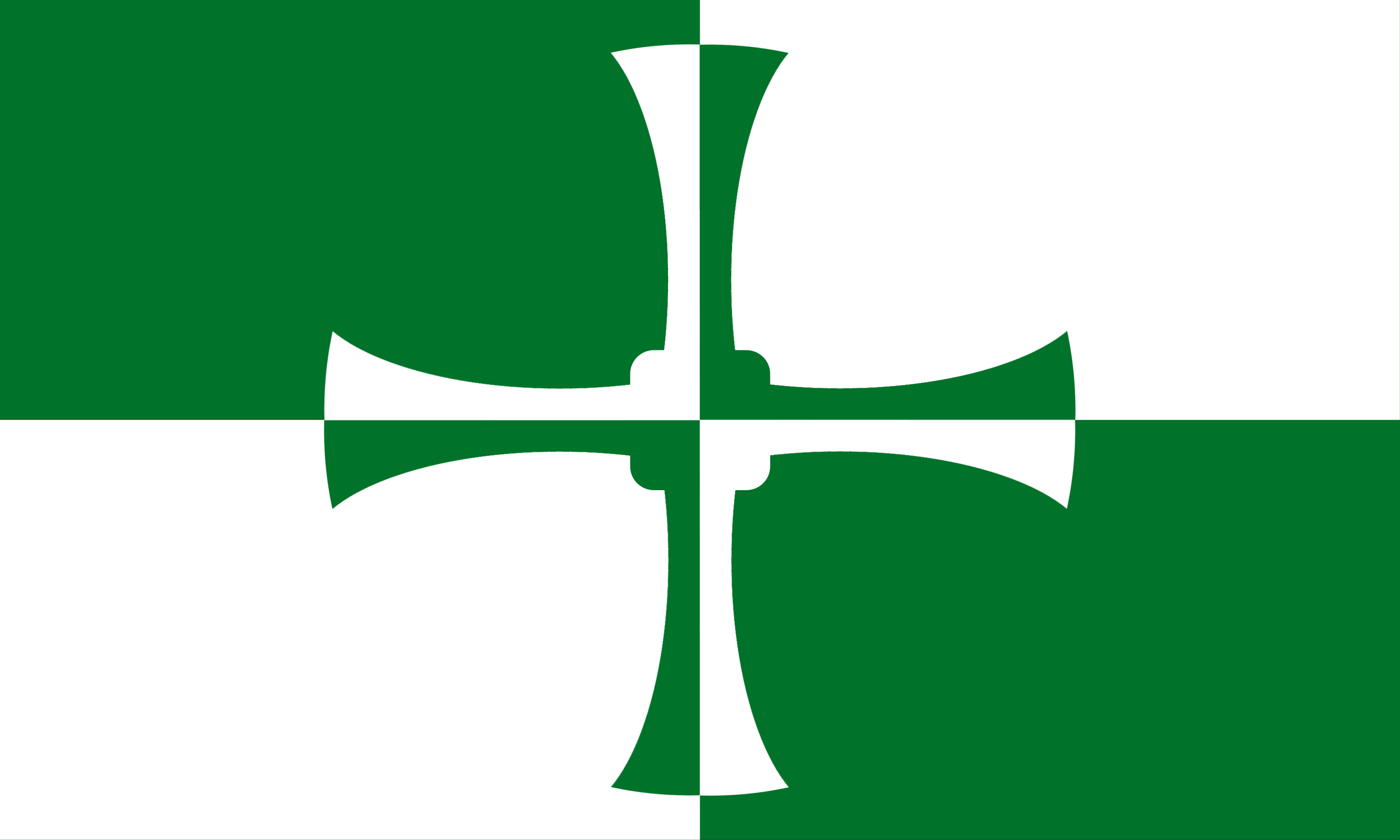
Loyalty to Dervorguilla and the House of Balliol meant that the people of Galloway were lukewarm in support of Robert I. In 1308 the county was brought under allegiance to the king, when the lordship of Galloway was given to Edward Bruce. In 1372 Archibald the Grim became Lord of Galloway and received in perpetual fee the Crown lands between the Nith and the Cree. He appointed a steward to collect his revenues and administer justice, and there thus arose the designation of the "Stewartry of Kirkcudbright". The Kirkcudbrightshire flag is a representation of St Cuthbert's Cross in a green and white check arrangement. The green and white design represents the checked cloth used to count taxes by the Stewards of the Lords of Galloway. The town and county of Kirkcudbright were named after the saint. The Anglo-Saxon saint’s remains were kept here for seven years between exhumation at Lindisfarne and re-interment at Chester-le-Street.